N/NE Portland could bring a cycle
track to N. Williams.
(Photo © J. Maus)
Metro has selected four active transportation projects to include in a grant application for possible funding through the U.S. Department of Transportation’s $1.5 billion Transportation Investments Generating Economic Recovery (TIGER) program.
The four projects, with an estimated total cost of $97 million, where whittled down from 27 that Metro received during a recent call for projects that went out to jurisdictions, agencies, and non-profit groups throughout the Portland region.
As we reported back in July, Metro decided to submit only non-motorized projects in their TIGER grant application and they wanted projects from each of three categories: “urban”, “suburban”, and “urban to nature”.
Here are the four projects, along with estimated costs, our comments, and a brief description from Metro:
Urban: North/Northeast Portland
Estimated cost: $38 million
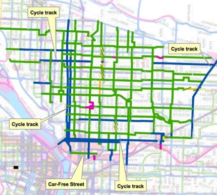
Develop a complete bikeway network with innovative international best practices. This demonstration project will show how to take bicycle transportation in America to the “next level.” … This project will implement 54.7 miles of planned bikeways… This project will saturate the area with active transportation infrastructure similar to that found in the world’s best bicycling and pedestrian cities.
This is very exciting project that was submitted to Metro by Roger Geller at the City of Portland’s Bureau of Transportation. Geller has been a proponent of this concept (pouring big money into bike infrastructure to show the country/world what is possible in America) for a long time and this TIGER program might be just the opportunity to finally make it happen. The goal of this project is to reach a bike mode share of 35% in the target area.
From a draft document detailing this project, we’ve learned that the 54 miles of new bikeways would include 10 miles of cycle tracks, 10 miles of bike lanes, and “a world-class bikeway every 750 feet” (although keep in mind that Metro might have altered the project prior to submitting the final application). Below is a draft map outlining the project’s boundaries and potential new facilities:

— Enlarge this map (PLEASE NOTE: Map is outdated and some projects shown did not make it through to final application. We’ll try to upload most recent map asap.) —
Suburban: Hillsboro – Access to high tech employment
Estimated cost: $ 21 million
The project is designed to alleviate barriers to bicycle and pedestrian access to light rail stations and key large employment sites. Highlighting the importance of linking bicycling and transit in low density areas, the City of Hillsboro’s package of strategic investments will help demonstrate that American suburbs can indeed be retrofitted toward active transportation integrated into daily life. The project will link areas of housing to employment centers, with direct, accessible, comfortable, enjoyable, and safe bicycle and pedestrian connections to existing light rail stations. The new active transportation connection will facilitate local travel and accommodate commute trips entering or leaving the Hillsboro community on High Capacity Transit.
Suburban: Milwaukie/Clackamas County – Access to industrial employment and new light rail
Estimated cost: $ 21 million
This project will demonstrate a forwarding thinking approach to improving multimodal conditions. This project is directly tied to the opening of a new light rail line. The proposed improvements will provide ‘last mile’ access to thousands of industrial jobs. Completion of pedestrian and bicycle infrastructure in this area would be a significant improvement in providing travel options such as walking and biking to work; alternatives that are simply not available today.
In both of the “Suburban” projects above, Metro’s Executive Council on Active Transportation is actively building coalitions with corporations (like Intel in Hillsboro) and business leaders that will directly benefit from these projects. The hope is to identify and work with project champions from the private sector that can help lobby for the projects and spread awareness about their importance to the region’s economy.
Urban to Nature: The Cazadero Trail from Boring to Estacada
Estimated cost: $17 million
Allow inner city residents to access natural areas without the use of an automobile.
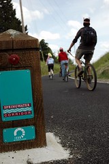
The Cazadero Trail is part of a larger long-term vision connecting Portland’s urban residents through the Mount Hood Connections (MHC) trail and greenway corridor. This corridor will provide a critical link between downtown Portland and the natural treasures found on the flanks of Oregon’s majestic icon, Mt. Hood. The vision for the corridor is to link Portland’s 21-mile long urban Springwater Trail system with trails that run along salmon-rich wild and scenic rivers, through old growth forests, to viewpoints that offer spectacular vistas of Mt. Hood and the surrounding National Forest. This project will finish the Springwater-Cazadero trail connection from Portland to the Clackamas River in the City of Estacada, the beginning of the West Cascades Scenic Byway.
All four of these projects represent an exciting new era for active transportation in our region. Metro continues to put major resources into non-motorized transportation and the important coalition building based around their Executive Council is evolving very quickly (more on that later).
The US DOT will make grant award decisions in February 2010 and projects selected must be completed by February 2012.


