
We hope you did your homework and read our latest charter reform story yesterday, because today Portland’s Independent Districting Commission (IDC) released its Draft District Plan Report. The document shows the three official draft districting maps that will aid the city in deciding geographic boundaries for the new City Council districts. It is with these districts that Portlanders will vote for 12 new commissioners in the November 2024 election and the new districts will go into effect January 1, 2025.
The maps are named Alder, Cedar and Maple. Below are the official maps and a brief explanation of each one:

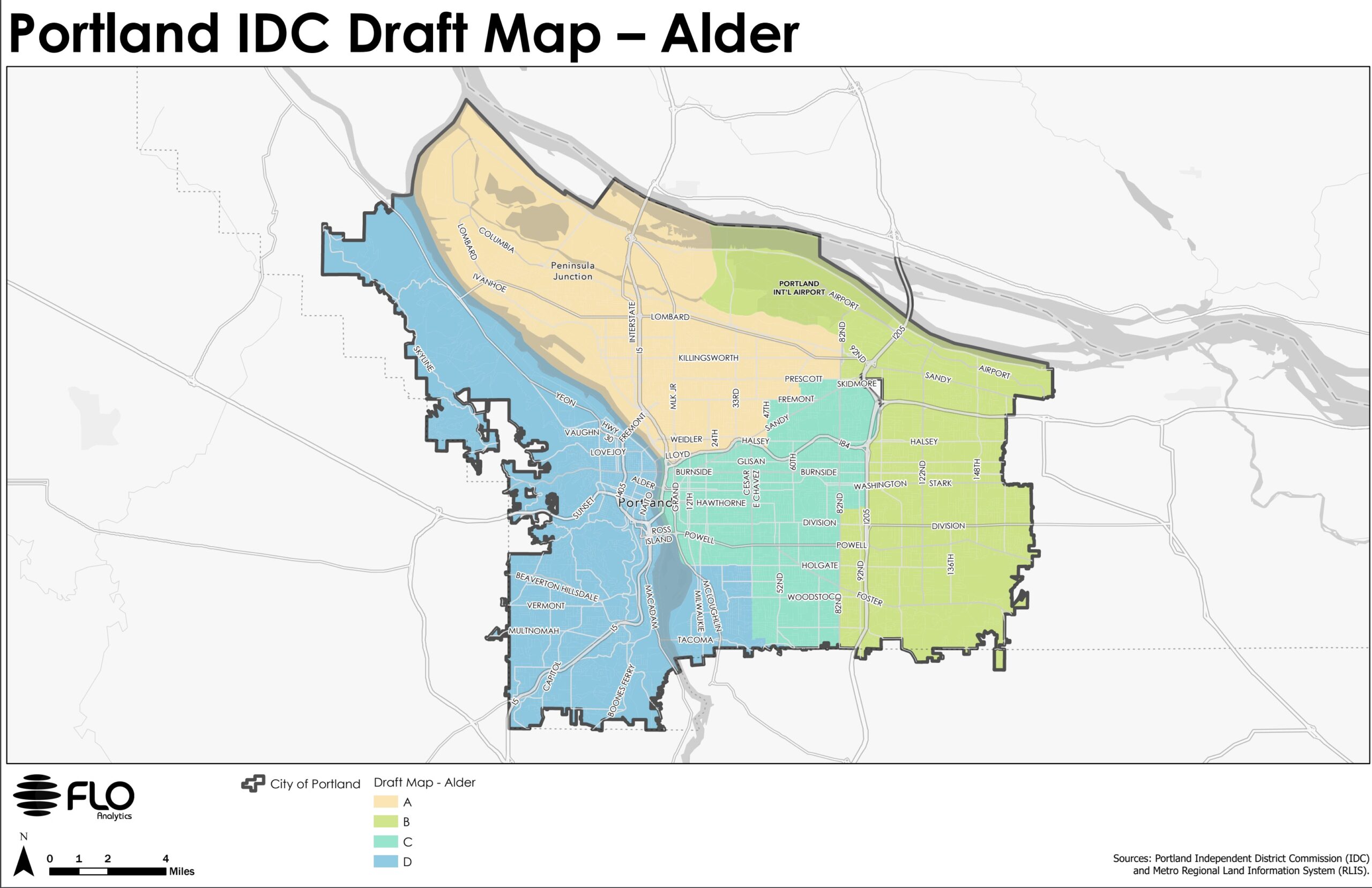
The Alder map is built around preserving established neighborhood boundaries. This map divides the central city among three districts, using the Willamette River and I-84 as boundaries, to promote broad engagement with central city issues and economic opportunities and distribute significant assets and institutions among multiple districts. Neighborhoods in lower southeast share a district with demographically and socioeconomically similar communities on the west side of the river and are connected by the Sellwood and Ross Island bridges.

The Cedar map is built around prioritizing transit corridors.This map uses transit corridors such as NE Sandy, SE 12th Ave, 82nd, and MAX lines to prioritize the role of these arterial roadways in influencing the use of public space and notions of neighborhood on the eastern side of the city. Neighborhoods in the central eastside and inner southeast that are bordered by the Willamette to the west and major transit lines to the east (bus and MAX) share a district with neighborhoods on the west side of the river.

The Maple map is built around keeping much of the central city together, as defined by the city’s Central City 2035 Plan, while preserving historic Albina and adding several inner eastside neighborhoods. The central ci ty includes the city’s most densely populated and urbanized neighborhoods, where residential and commercial uses are tightly interwoven. Eastside neighborhoods with high percentages of renters (Central Eastside, Buckman, Kerns) share a district with westside renter-heavy neighborhoods (Goose Hollow, Old Town, University, South Waterfront) as well as other westside neighborhoods.

The document also includes summary statistics for each map as well as a list of key differences between them:
Crossing the Willamette River
The Alder map crosses in lower southeast only.
The Cedar map crosses in the central eastside and southeast.
The Maple map crosses in the central eastside onlyBoundary between N/NE and SE/central districts
The Alder map uses neighborhood organization boundaries.
The Cedar map uses Sandy Blvd
The Maple map uses both (Rose City Park is in one district, while Roseway is divided by Sandy Blvd)
Based on extensive community input so far, all of the maps share certain features:
- All communities east of I-205 are in a single district
- The Parkrose, David Douglas, Reynolds, and Centennial school districts (the four non-PPS school districts) are in a single district
- Neighborhoods along the northern part of Portland are in a single district, with the exception of neighborhoods in the Parkrose school district
- The north and south sides of Columbia Boulevard are in a single district
- Historic Albina in N/NE Portland is preserved in a single district
- All communities west of the Willamette River are in a single district
- The western border of the easternmost district runs along I-205 and 82nd to accommodate the Jade District and Lents neighborhood
The committee seeks and responds to community input. The report lists eight upcoming public meetings, as well as an email address where you can submit comments. Learn more at the District Commission’s website.