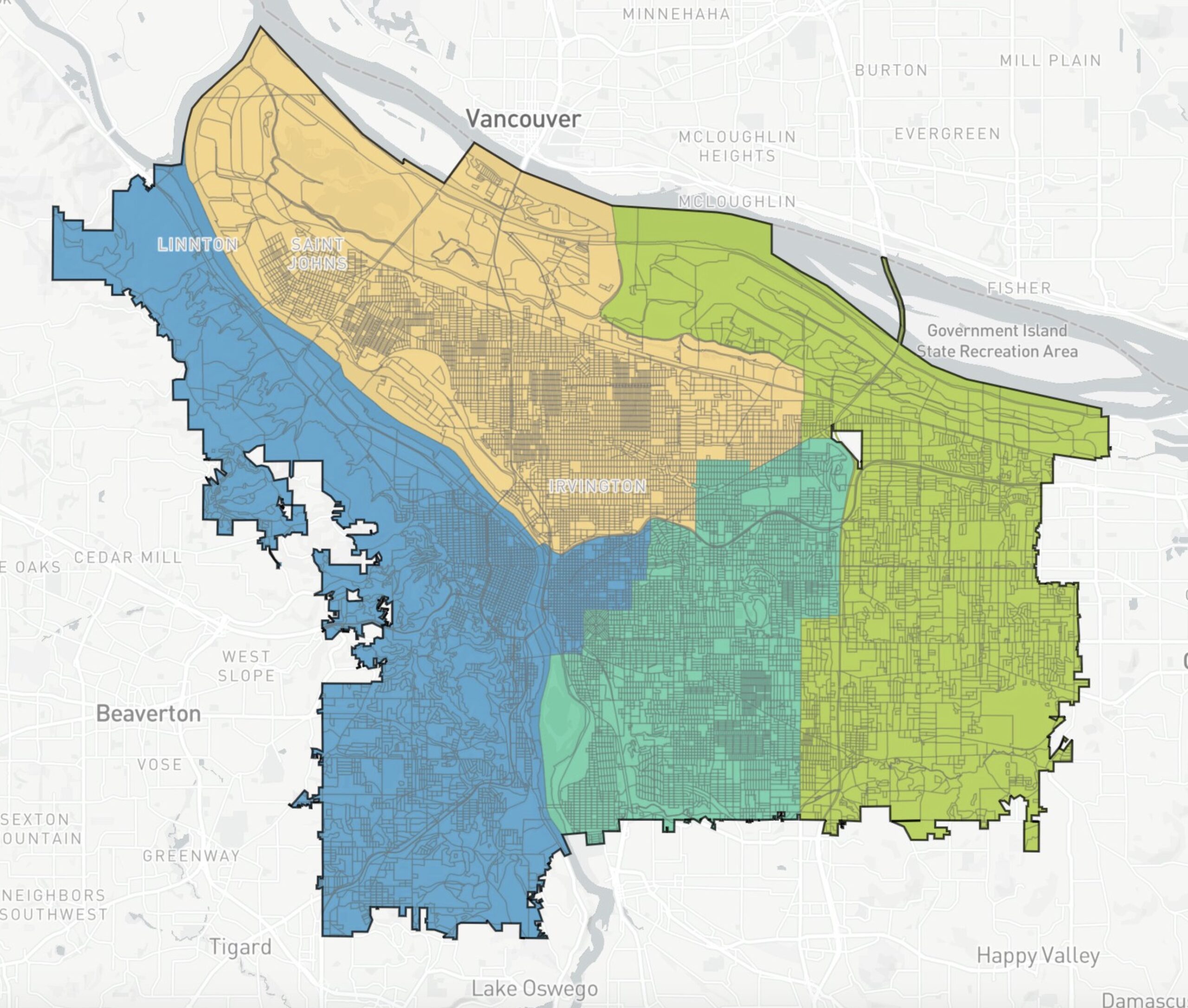
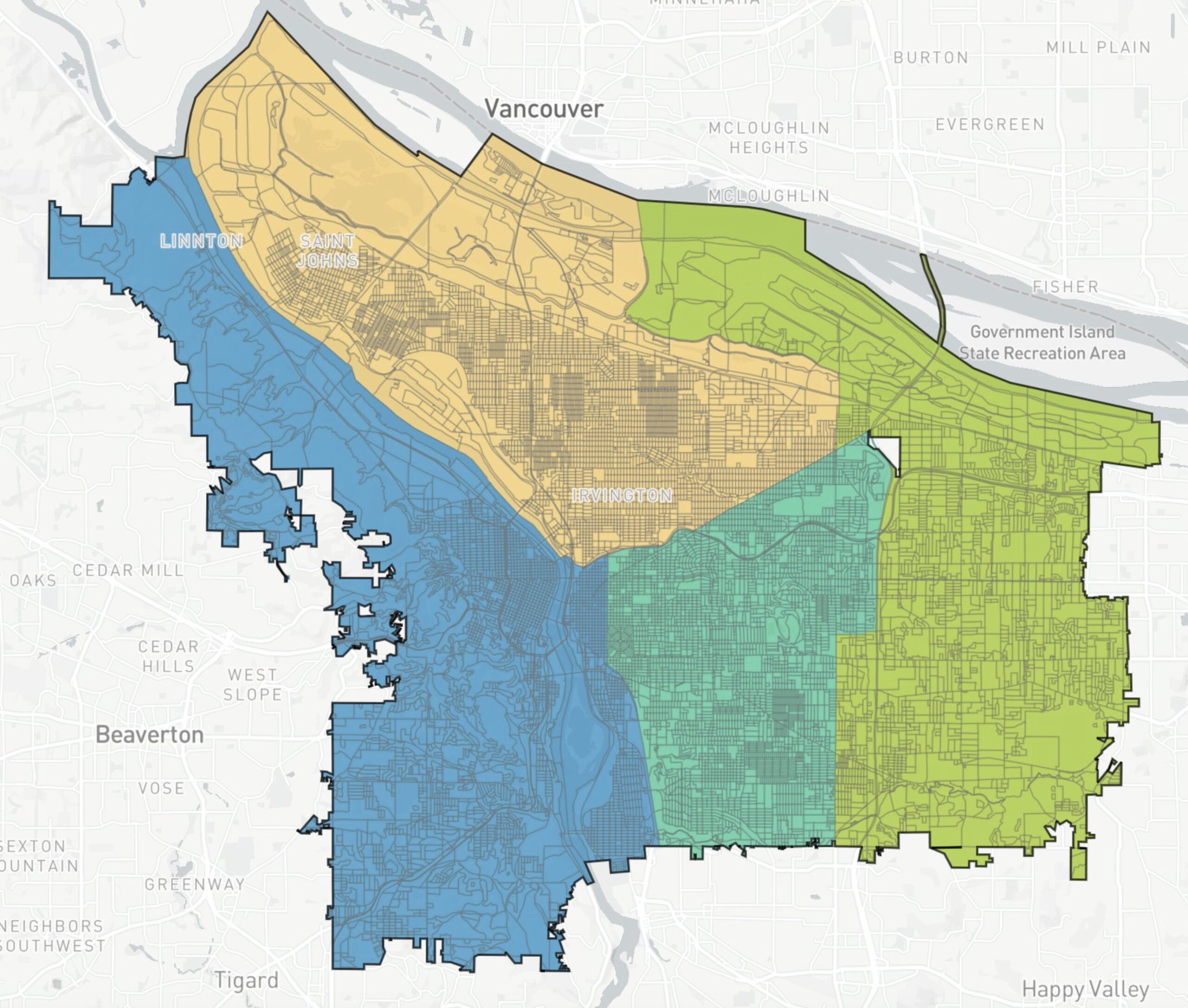

Portland’s Independent Districting Commission (IDC) has selected three draft maps of potential City Council voting districts to present to the public. These are the maps that will set new geographic boundaries for the four city council districts under the new form of government and will be in effect for the November, 2024 election.
At a three-hour work session Wednesday night, each plan was presented by a sponsoring commissioner who then fielded questions from the other commissioners. The group could choose to present one or more maps to the public in a series of meetings to be held in July, and ended up deciding to put forward all three.
Last night’s meeting was far from perfunctory. The usual Portland political tensions, such as how or whether to honor established neighborhood boundaries, were given voice by several committee members. The group was ably guided by the facilitator and the decision to forward all three maps came in a close 8-5 vote.

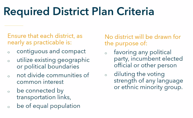
The 13-member, volunteer commission was appointed by Mayor Wheeler from a pool of 282 applicants and approved by the City Council at the end of January. They have spent the past four months immersed in the nuances of drawing districts, and face a deadline of September 1st to present a final, publicly-vetted draft map to City Council. If a super-majority of nine of the 13 commissioners approve the final draft map, it will go into effect. Otherwise, it goes to City Council for a vote.
Before the September deadline, the committee will hold at least two public hearings in each proposed district, for a total of eight public meetings.
The committee intends to publish the draft maps on Friday (6/2), and the plan is to annotate them with notes explaining the reasoning behind their boundaries, and to include some discussion from last night’s meeting. Several committee members expressed concern that without background and explanatory text the public might not be aware of the criteria required for drawing districts or the issues the various boundaries address.
The Commission
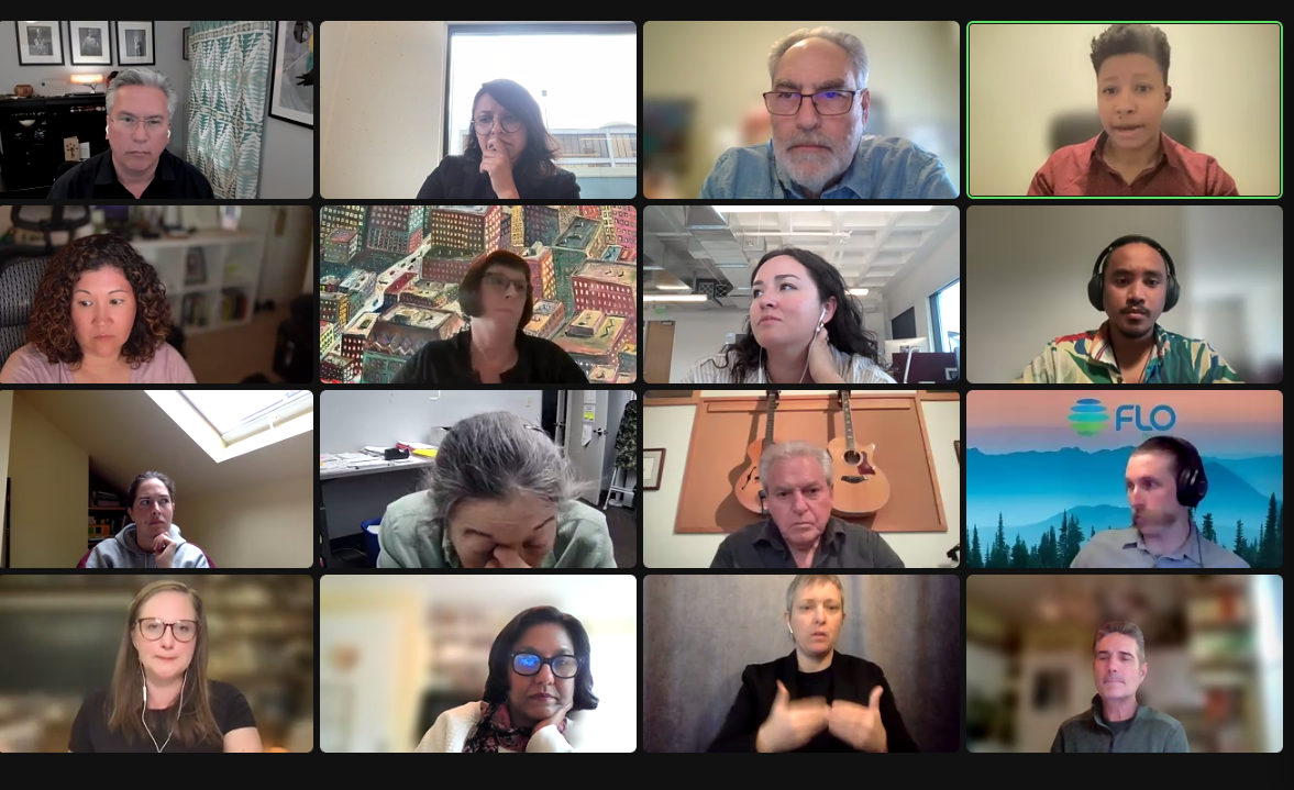
The commission itself is an impressive and highly qualified group of people. I felt like I was watching the Tour de France of Zoom meetings. The IDC is one of three committees described by last fall’s charter reform amendment to transition Portland from its current century-old commission form of government to a system of geographic district representation.
Portlanders can be confident that this group has taken seriously their historic responsibility to draw the boundaries of the city’s first geographic districts.
The vote on which maps to present to the public came at the end of an arduous meeting in which commissioners made clear that they had grappled with the intricacies of ensuring fair representation in Portland. Here are some of the issues that the commission has considered.
What makes districting in Portland unique
There is no perfect map.
– Members of the Independent Districting Commission
Several commission members had attended an information session about districting presented jointly by the North Star Civic Foundation and Common Cause earlier this month, in which two districting experts shared their experiences from Los Angeles and the Bay area. The idea of city assets figured largely in that conversation, and it was an aspect of drawing districts that I, and perhaps some commissioners, hadn’t considered before: distribution of assets.
Distribution of assets
What is a city asset? It can be an institution, like museums, universities, zoos, sports venues, parks. But it can also be a location. One fun example from LA was the route of the Rose Bowl parade, which offered city councilors representing those districts a high-profile opportunity to appear before the public, waving from a float.
The gist was that having city assets in one’s district brings visibility, power and connections to a representative. Designing districts so that assets are distributed somewhat evenly between representatives fosters cooperation and collaboration.
The North Star/Common Cause information session made a lot of sense, but there were limits to its relevance to Portland. A reality of our city is that most assets are concentrated west of the Willamette River: the largest universities, the art museum, the big concert and theater venues, biggest park, biggest employer, zoo, civic stadium, central library. The distribution of assets in our city is lopsided.
This becomes particularly relevant when deciding which section east of the Willamette should be joined to a west side district to reach required population parity between districts (the west side does not have a large enough population to comprise a single district without an area from the east side joining it). The concern is that “asset-packing” in a single district might bring advantages to the representatives of a particular district.
The difficulty is that the close-in, east-side-of-the-river areas are also asset-rich. Moreover, some neighborhoods, like St. Johns apparently, really don’t want to join the west side.
A largely white city
Portland is one of the whitest cities in the United States and, with the exception of the Asian population, the city’s people of color (POC) are distributed somewhat evenly throughout the city. We don’t have highly ethnic enclaves.
The ranked choice voting in multi-member districts method itself is an attempt to bring fair, proportional representation to people and views which cannot be corralled into a particular geographic location. It is not possible in Portland to create a majority minority district. Because of this, many people repeatedly lose their voice in our current at-large voting system.
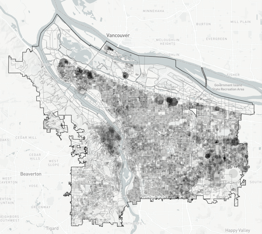
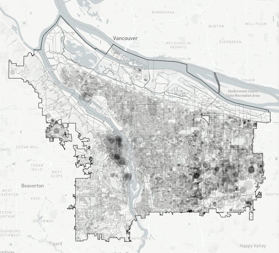
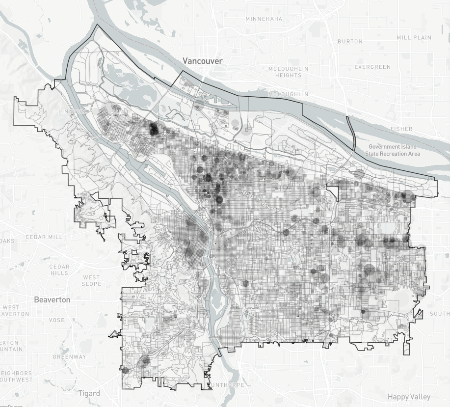
For example, these maps from the DistrctR tool (which is being used by the IDC) show
1) the distribution of the 11% of the Portlanders who identify as Hispanic. As you can see, there isn’t a single Hispanic neighborhood, the population is distributed throughout the city.
2) The Black population at 5.7% is, to a lesser extent, also spread throughout the city.
3) The 8% Asian population is more concentrated east of E 82nd St, and also in downtown.
These distributions led to discussions last night about which neighborhoods should or shouldn’t be divided between separate city council districts. A lot of time was spent talking about what is called the Jade district, an area in east Portland with a high concentration of Asian businesses.
One commissioner mentioned that he had been in contact with APANO (Asian Pacific American Network of Oregon) and Duncan Hwang (Metro Councilor and Community Development Director of APANO), and had learned that, counter-intuitively, the Jade Business district leaders were fine with being split across two districts. The rationale being that it would give the community the ear of six, rather than just three, city council representatives.
Geographic barriers, population and culture
All of those concerns layer on top of the history and geography of the city. The main reason there is not more of a concentrated Black neighborhood is because residents of lower Albina were displaced by: the alignment of Interstate 5 through the heart of their neighborhood; the destruction of housing due to planned Legacy-Emmanuel Hospital expansion and; the construction of Lloyd Center. That destruction was followed by years of gentrification.
Geographically, the river is a natural boundary, but the population west of it is not large enough to be a district on its own. The river is also a political/cultural boundary, with one of the few resentments still socially acceptable to publicly express being animosity toward the west side. So it is understandable that some eastsiders are not eager to join a largely westside district.
What the IDC needs from you
Several commissioners repeated the phrase that “there is no perfect map” and emphasized that the draft maps were a starting point for further discussion. Borders can be tweaked, and the Commission seeks public feedback. Many times during last night’s meeting commissioners recognized that they needed to find out what people think, that the IDC doesn’t have all the answers.
That’s where you come in. Find a July meeting, fool around with DistrctR, write a letter. The draft maps should be released tomorrow, and most likely the IDC will begin receiving a torrent of advice. Stay tuned for a follow-up.