The plan to create a new district surrounding the Oregon Museum of Science and Industry (OMSI) has been in the works for almost 15 years. Tomorrow, proponents of the plan to redesign 34 acres of land in Portland’s central eastside will ask the city’s Design Commission to review their proposal – the most concrete action yet toward breaking ground on the transformative development project.
If all goes according to OMSI’s plans, the project would come with a major new bikeway.
OMSI is a favorite destination for Portland tourists and locals, located near a slew of multimodal transportation options – including MAX light rail, streetcar, bus, bikeways and even a (dormant) submarine. But the museum is located in an industrial part of town with few other nearby attractions.

If it comes to fruition as project boosters want, the OMSI District will include a new waterfront education park and create new access to the Willamette River. It will also be the site of major new residential and mixed-use development, with plans to build up to 1,200 new housing units alongside new restaurants and businesses.
The success of these plans hinges on a major redesign which project proponents say will allow the district to safely accommodate people biking, walking and rolling through the neighborhood while also maintaining car and freight access.
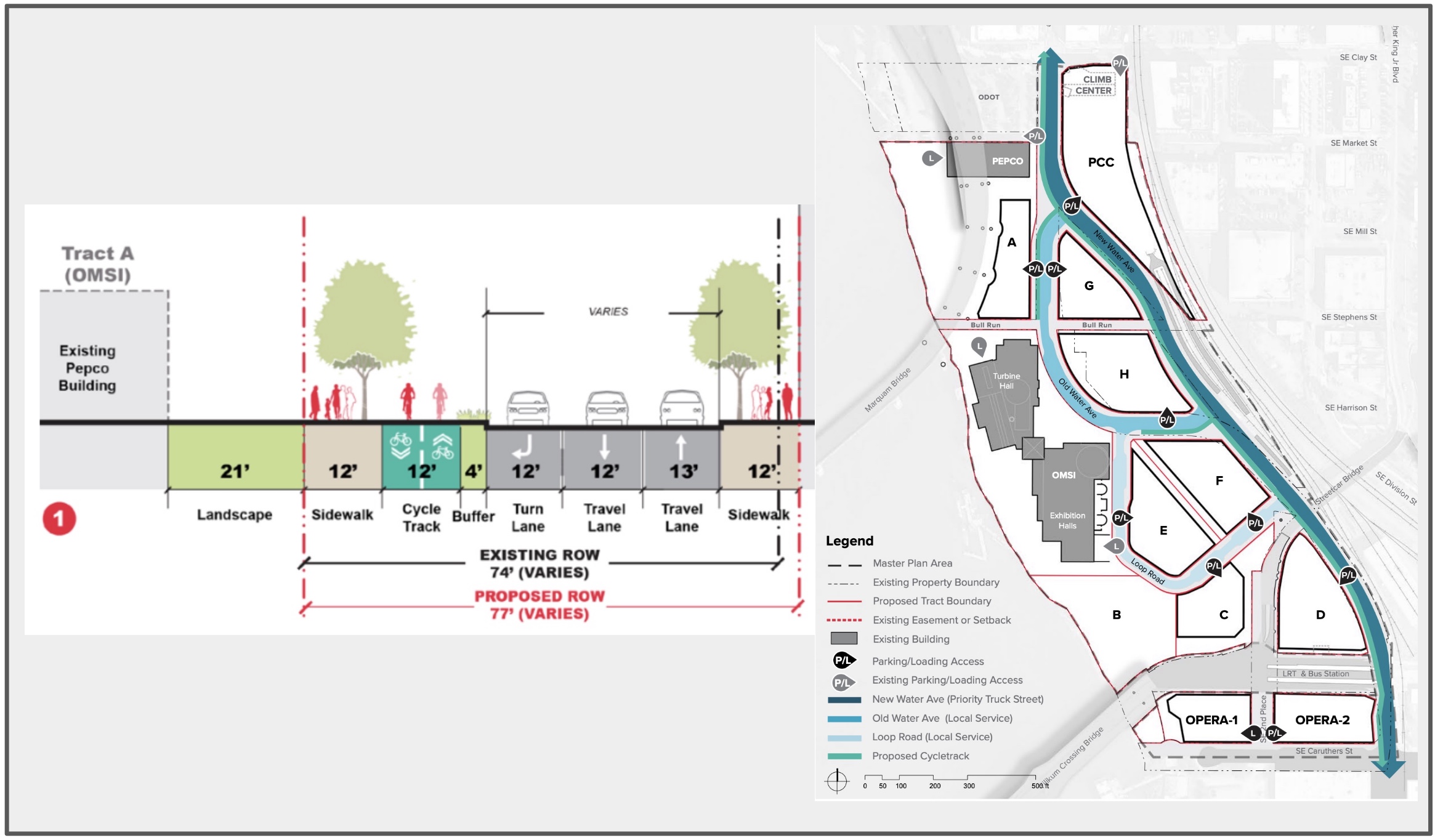
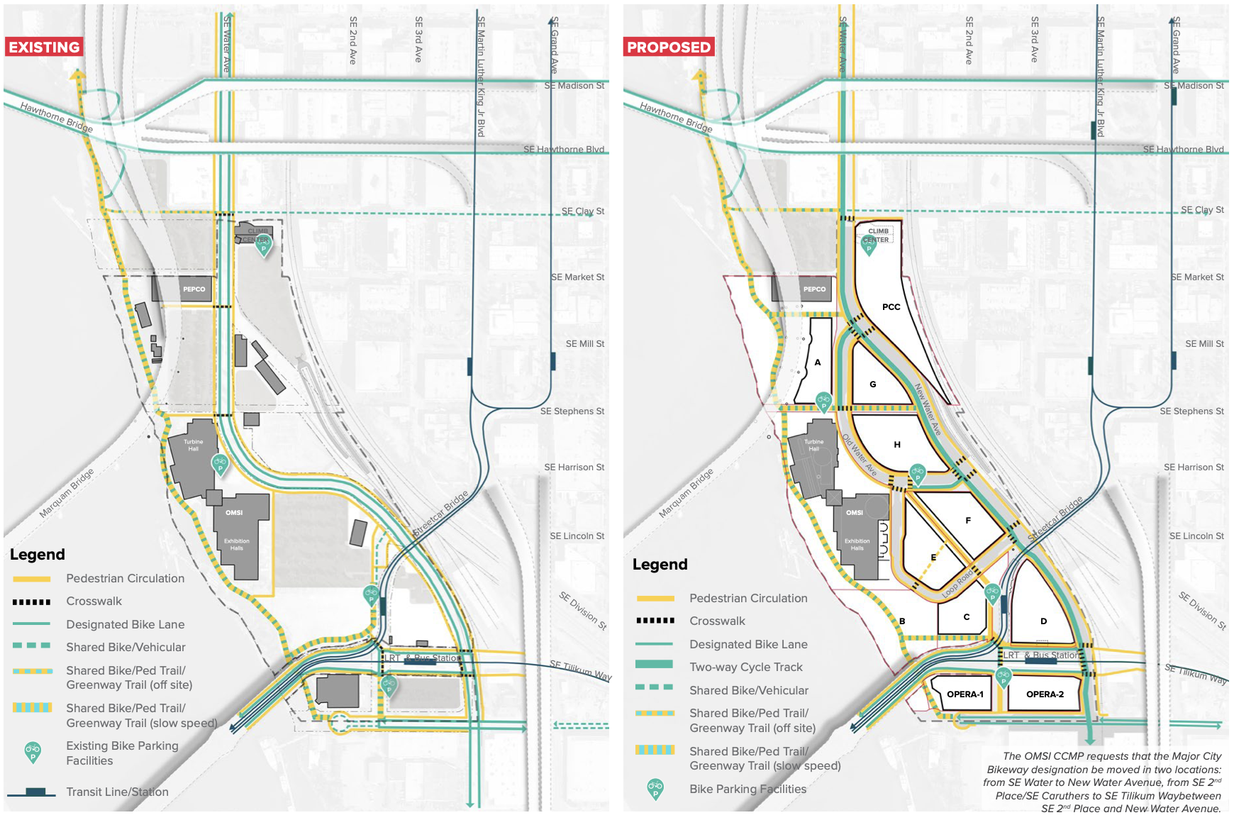
OMSI wants to realign SE Water Avenue, which forms the district’s spine, to the eastern edge of the plan area. This would split the street into two – “New” and “Old” Water Aves – which would serve different purposes for people traveling through the area. There would also be a Loop Road to the south of Old Water Ave and a “central pedestrian spine” running through the district.
“New Water Avenue will allow freight and vehicular traffic heading through to points north or south the center of the plan area on a street with softer curves and fewer access points, while Old Water Avenue is prioritized for pedestrian activity and local service and loading access,” OMSI’s land use review application states. Plans for New Water Ave show 12-feet of dedicated cycling space split between 2 bicycle lanes (six feet each) next to 37-feet split between three, 12-13-foot wide standard travel lanes (which seems excessively wide for a road like this).

New Water Avenue will be “the most direct and convenient route” for through car and truck traffic and include a two-way bikeway along the west side of the street. This new bike route would provide a connection from the central eastside to the Tilikum Crossing Bridge and would also connect the Hawthorne Bridge with the Springwater Corridor path.
Old Water Ave will also have the two-way, 12-foot bikeway — except for one block in front of the main plaza where the plans show the bikeway vanishes and is replaced with a bus lane.
But as we’ve pointed out before, the existence of this New Water Ave wouldn’t be a deterrent to people biking on the Eastside Esplanade or within the OMSI district. Old Water Ave will integrate a two-way cycle track as well, and the plan is to include 12-foot-wide sidewalks with 8-foot through pedestrian zones, street trees, and landscaping.
Advocates for the Green Loop around Portland’s central city foresee the OMSI district playing a key role in the future active transportation circle. With two carfree bridges on either side of the district – the Tilikum Crossing and the new Blumenauer Bridge – its in a good position to offer active transportation connections to the rest of the city.
Because this project is so large, it won’t be able to receive approval without significant conversation between the involved city bureaus and organizations. There is already some design pushback beginning to emerge: a staff report released earlier this month includes a skeptical memo from PBOT’s engineering department, which states “while the layout and general geometry of the existing and new public streets acceptable, the details including lane widths, stacking lanes depth, location and design of protected bike lanes, and the number and location of new traffic signals is still under review.” They note a particular concern with how cyclists will enter the new district just south and north of the site. All of this will be up for conversation at Thursday’s hearing.
The Design Commission plans to review the OMSI district plan from 4-6 pm at tomorrow’s hearing. You can register to testify here, and stay tuned for updates as the plan moves forward.