

Five years of process and planning is finally starting to yield some fruit tangible fruit. We now have lines on the map and can begin to visualize a network of protected, family-friendly bikeways in the central city.

(Photos © Jonathan Maus)
Today the Portland Bureau of Transportation launches the second of a three-phase online open house for their Central City in Motion project. The website includes a “What we learned” section with key takeaways from the 1,400 comments they received since the first open house last March as well as feedback garnered from design workshops and advisory groups. The site also includes an interactive map that reveals which streets — and which designs — are likely to move forward when construction begins in 2020.
In addition to a network of safer bikeways, the project will also build safer crossings (blue circles on map) and create dedicated bus lanes to speed up transit (thick blue lines on map).
PBOT has a total (so far) of $30 million set aside for this project: $6 million from a federal grant, about $3 million in local gas tax revenue, and $20 million from System Development Charges.

For each project shown on the interactive map PBOT has supplied a cross-design concept (they say they left off exact lane widths to keep it simple, expecting many non-wonks to participate and comment). They also ask three specific questions: “How effective would this project be at moving more people around the Central City as it grows?”; “How effective would this project be at attracting new people to transit, biking and walking?” and “Do the benefits of this project outweigh the potential impacts?”
PBOT Project Manager Gabriel Graff said in a phone interview this morning that they are trying to develop “the backbone of the bikeway system” by taking a “rungs-and-ladders approach.” Graff and his team are looking for north-south and east-west couplets that will help people enter and exit downtown — with a special focus on getting as many people as possible up and onto the bridges. Our current system of streets has resulted in too much gridlock because too many people choose to drive. If PBOT gets this right, a lot more people will choose bike, walk, and take the bus which would make the road system much more efficient and pleasant for everyone.
West of the river

On the project’s northwestern edge, PBOT has selected NW 14th and 16th between Burnside and Thurman to act as the main north-south bikeway through the Pearl District. Their current design concept shows parking protected bike lanes the entire length of this couplet separated with a painted buffer and plastic delineator wants (or other material yet to be determined). South of Burnside, they’ve proposed the major north-south bike route to be Broadway (southbound) and 4th (northbound) along with Naito Parkway along the river.
Advertisement
“Given the amount of people walking on transit mall and the number of turns by transit vehicles. It just didn’t seem like we could create a better biking environment within the framework of this project.”
— Gabriel Graff, PBOT
If the Broadway project holds in its current form, we would finally have a protected bike lane from Portland State University all the to the Broadway Bridge — something PBOT has intended to do since the existing bike lane was installed as part of former Mayor Sam Adams’ “First 100 days” promise in 2009. PBOT refers to this as a “signature, protected southbound bicycle facility through downtown Portland.”
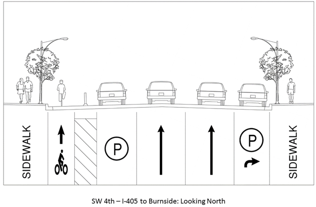
4th Avenue would be the northbound “siganture” bikeway route through downtown, giving riders a protected bike lane from I-405 to the Steel Bridge. PBOT says 4th’s bike lane would be on the left side of the street in order to avoid the high volume of right-turning drivers who leave downtown and head east to the bridges and I-5. Like many of the proposed projects, road space on 4th Ave. would be reallocated from driving or parking cars to dedicated space for cycling. For years, PBOT has maintained that downtown streets are safe to cycle in in a shared-lane environment because signals are timed for a reasonable 10-12 mph. They now realize that’s only true for a small percentage of would-be riders, and these designs reflect that new thinking.
For east-west bike routes downtown, PBOT is proposing protected bike lanes and bus priority lanes on Jefferson/Columbia and Salmon/Taylor.
One thing you won’t see on this map: PBOT has taken the transit mall on 5th and 6th, off the table. Why? “Given the amount of people walking on transit mall and the number of turns by transit vehicles,” Graff said today. “It just didn’t seem like we could create a better biking environment within the framework of this project.” On the “What we learned: Bikeway” section of the open house, PBOT writes, “Creating a low-stress bikeway on the transit mall (SW 5th and 6th Avenues) isn’t feasible due to the large numbers of pedestrians and personal and transit vehicles using the mall.”
East of the river
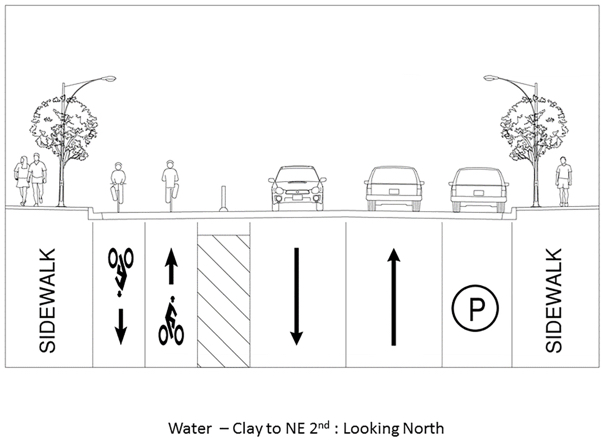
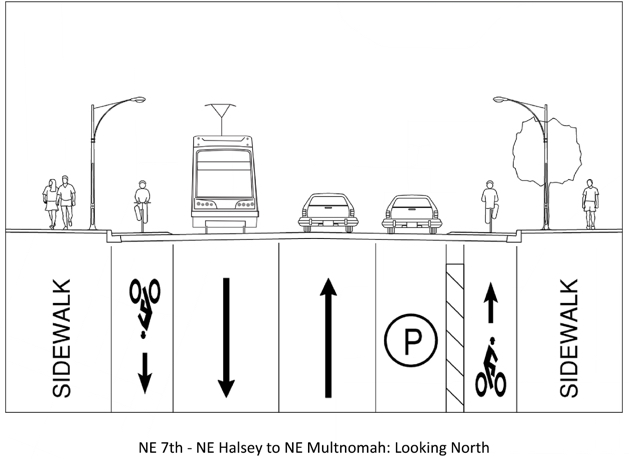


On the central eastside, Water, 7th, and 11th/12th would form the network. Water would get a two-way protected bike lane from Clay to NE 2nd. There are three cross-sections shown for 7th, ranging from protected bike lanes on both sides in the southern portion to a shared-lane environment near Benson High School and then back to protected bike lanes across the (future) Sullivan’s Crossing Bridge and through the Lloyd District.
On SE 11th and 12th, PBOT said the proposed design would be a “Stark and Oak-like treatment” where the bike lane would be adjacent to other lanes and there would be auto parking on both sides.
Now PBOT needs to hear your feedback to help them continue to refine their maps in advance of the third and final open house set for later this summer. At that open house we’ll see a tiered list of projects with more detailed cost estimates. The final plan is expected to be adopted by City Council in September.
Check out all the proposed projects and cross-sections — and be sure to share your feedback — here.
— Jonathan Maus: (503) 706-8804, @jonathan_maus on Twitter and jonathan@bikeportland.org
Never miss a story. Sign-up for the daily BP Headlines email.
BikePortland needs your support.