

(Photo © J. Maus/BikePortland)
Maps matter. On December 12th Martin Greenough was killed while biking on a road that looks like a safe bikeway on popular bike maps. While infrastructure can take years to change, maps can be edited quickly. And that’s exactly what is starting to happen.
Metro, our elected regional government and publisher of the Bike There! map, has responded to our reporting on Martin’s death by adding a caution symbol to the bikeway gap where he was killed.
Here’s how the current printed version of the Bike There map looks (the east-west green line is Lombard Ave/Portland Hwy):
Advertisement

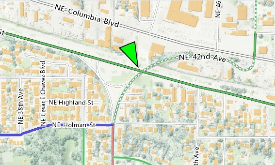
And here it is with edits just made in the online version of the map (note the red dots and red line on Lombard):

Locals know that this section of Lombard is an unforgiving place to ride; but Martin was new to town. He was also a fan of paper maps and his close friends have told us he used a printed bike map to find his route to and from work.
Our story last week explaining why Martin might have chosen to ride through this dangerous gap in the bike lane has brought to light a major shortcoming in the maps many people use to navigate our streets. Maps from the City of Portland and from Metro don’t do enough to differentiate between the safety of different bikeway types.
Until Metro’s actions (which only impact the online version of the map for now), none of our local maps had marked the bike lane gap where Martin died as a caution zone. This is a section of road with a severe pinch-point where people commonly drive 50 mph. I’ve stood where Martin was hit and it made me equal parts afraid and angry…

Metro has made the edit to the online version of their map. Unfortunately the printed map was just updated so it will still be a few years until these changes are reflected.
In an email, Metro’s Craig Beebe said the changes came after the agency realized the “challenging issues of the mismatch between maps, people’s perception, reality on the ground and, of course, the patterns of travel that people have to take every day to get where they’re going.”
Here’s more from Beebe:
“… Your reporting on the city of Portland’s bike map led us to take a look at how that stretch of Lombard was designated on Metro’s Bike There map. We saw that we had marked the entire stretch as having bike lanes. In Metro’s more experience/comfort-based taxonomy we marked this as ‘suitable for experienced riders.’
As a result of this crash, and your reporting, our lead cartographer for Bike There, Matthew Hampton, updated the online version of the Bike There map to mark the bike lane gap and to add a dashed-red line to the entire stretch of Lombard, denoting ‘ride with caution.'”
We haven’t heard yet whether the City of Portland plans to make edits to their maps as well.
— Jonathan Maus, (503) 706-8804 – jonathan@bikeportland.org