
We have important updates on a story we shared yesterday about a historic step forward for off-road cycling in Portland.
As you might have heard, Metro is on the verge of finalizing a plan that would develop several mountain parcels north of Forest Park. Two of the parcels are slated to include singletrack trails built specifically for mountain biking. If built, these trails would represent the largest network of off-road bike trails ever developed in Portland. In advance of a final public meeting about the plans that will be held tonight, Metro has published the meeting materials on the project website.
In addition to giving you a more detailed look at Metro’s plans, I also want to elaborate on a point I made in yesterday’s story about the people who are organizing opposition to the bike trails. A key point in their case against Metro’s inclusion of the trails in these plans is a contention that the land was purchased solely to protect habitat and that, “a mountain bike park is contrary to the terms of the levy.”
I tracked down the resolution passed by Metro Council in December 2012 that lays out the levy in detail in order to show that cycling — even in these specific parcels — was called out as a possible use from very early on.
First, let’s take a closer look at the plans Metro will present tonight…
Of the four parcels that make up the North Tualatin Mountains, Metro will only develop two of them: Burlington Creek Forest and McCarthy Creek Forest. Here’s a map to give you some context on the location of the four parcels. The two stars are where bicycling trails will be built. Multnomah Channel and Highway 30 are in the upper right and the northern boundary of Forest Park is in the lower right:

The 339 acre Burlington parcel will be the first phase of the project and it will get most of the attention.
The Burlington Creek area is located adjacent to Highway 30 just south of McNamee Road (or Cornelius Pass Road, if you aren’t familiar with McNamee). Metro’s plans call for a fully developed trailhead south of McNamee Road that includes parking for 15 cars, a restroom, a picnic table, and so on.
As for riding a bike at Burlington, there will be a total of 6.15 miles of trails and gravel roads. The breakdown is 2.7 miles of gravel road; 1.2 miles of shared trail; and 2.25 miles of what Metro calls “off-road cycling optimized” trail.


The 403 acre McCarthy Creek Forest parcel is south of Burlington Creek. The main entrance will be off of NW Skyline Blvd where it intersects with McNamee Road near the Skyline Grange (there will be two additional trailheads on McNamee).
Advertisement

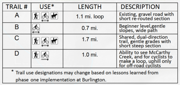
Metro will develop McCarthy as a second phase of the project and trail alignments are flexible based on lessons they learn from Burlington. That being said, Metro’s current plans include 4.5 miles of trails and gravel roads — all of which will be open to bicycle riders. Of particular note is a 0.7 mile beginner loop near the main entrance that will be build specifically for cycling. plans to build some beginner-friendly mountain bike trails.
Here’s the map and the trail breakdown:
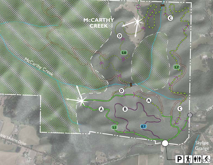
Keep in mind that it will be possible to bike between these two parcels on McNamee Road (I’m not aware of a dirt connection, can anyone shed light on that possibility?).
Given the disappointments of Forest Park and more recently River View, these plans are a breath of fresh air.
However, not everyone feels this way. An opposition is organizing and they plan to tell Metro that allowing biking on these parcels goes against the terms of the 2013 levy. We looked up the resolution that endorsed the levy as passed by Metro Council on December 18th 2012. On page 16 of the resolution (PDF here), there’s a paragraph that refers to Agency Creek (former name of Burlington Creek) and McCarthy Creek.
Here’s the passage (emphases mine):
Various parcels near to but outside of Forest Park are currently or could be used by walkers or cyclists to access nature close to Portland. Access to the site is challenging and there may be opportunities to enhance use. Over the past decade the demand for single track mountain biking trails has increased. This project would explore the potential to provide quality cycling and hiking experiences for formal singletrack cycling and walking trails, and as appropriate, construct the facilities.
Andy Jansky with the Northwest Trail Alliance says his group fully supported the levy and has worked closely with Metro on these plans as a member of their advisory committee. He hopes mountain bike riders show up to the meeting tonight to show Metro that trails like this are needed and supported by the community. He also shared some advice about what to do at the meeting.
“Find a Metro staffer and tell them you story. Tell they why you’re so passionate about the outdoors. Then talk to a neighbor and have a conversation about who you are and why you love to ride your bike. This is a community event, it’s not the place to complain or pick fights.”
We’ll be watching this project very closely over the coming weeks and months. Stay tuned for more coverage. If you have support or criticisms of Metro’s plans, email Olena Turula at Olena.Turula@oregonmetro.gov.
— Jonathan Maus, (503) 706-8804 – jonathan@bikeportland.org