

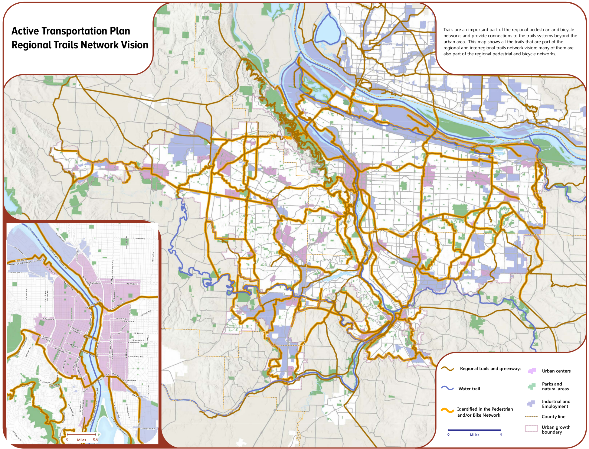
When you stitch together the long-term bike plans of every city in the area, connect a few dots and put it all on one map, you get something pretty spectacular.
“We want to move away from ‘bike lane ends’ or ‘trail ends.’ People don’t know when they’re passing from one owner of a road or into a jurisdiction. So we want that completeness across the region.”
— Lake Strongheart McTighe, Metro
That’s what regional government Metro did this summer, when its council unanimously approved the region’s new active transportation plan.
Assuming Oregonians don’t make any radical decisions such as earmarking, say, an additional 5 percent of our annual gas tax revenue for off-road urban paths, the network pictured above will take many decades to build. But even at today’s rates, the state, region and cities are chipping away at this plan; look at the Tualatin River Greenway gap, which outscored 99 out of 103 other transportation projects from around the state last spring to get $1.4 million from Oregon Lottery revenues.
You can see that 0.8-mile project in the cluster of yellow lines southwest of Lake Oswego. If you zoom way in.
Metro’s “Active Transportation Plan Regional Trails Network Vision,” as it’s known, is as big as its name. But that’s the point, says its architect, Lake Strongheart McTighe.
Advertisement
“The regional plan is really a way to coordinate all of the various efforts that are happening around the region so that the sum of the parts is really great,” said McTighe, a senior transportation planner at Metro, said in an interview Tuesday. “We want to move away from ‘bike lane ends’ or ‘trail ends.’ People don’t know when they’re passing from one owner of a road or into a jurisdiction. So we want that completeness across the region.”
An example: the new Active Transportation Plan, for the first time, identifies a “Beaverton to Milwaukie Trail” that would run alongside Highway 26 through the West Hills, joining downtown Portland’s hub of trails with the developing network in Washington County.
Here’s another big map in Metro’s new plan: one that includes not just off-street paths but also on-street routes.

This map has a similar motivation, McTighe said: helping every jurisdiction make sure their blue lines line up.
“We want to always be emphasizing that if Portland is putting in a buffered bike lane on, like, Division, then we want that bicycling and pedestrian improvements to extend all the way through to Gresham, or have some sort of meaningful connection as it weaves through,” McTighe said.
The new Regional Active Transportation Plan is a landmark document, and this vision is just a piece of it. You can learn more about it, and download all the analysis of these maps, here.