
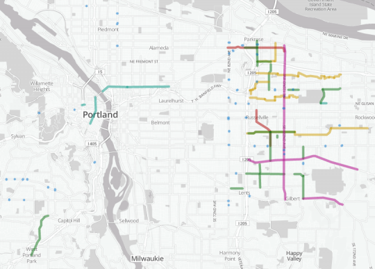
(Graphic by BikePortland using Transitmix.net. Click for an interactive version.)
So far, the public debate about a per-household and per-business street fee has been mostly about the costs: who would pay how much.
While that debate rages on, the city has finally floated some specifics about the possible benefits.
Above is a map of almost every project included in a so-called “straw man” list of street projects, to be completed over the first six years of the street fee, that would make it safer and more comfortable to bike and walk within Portland city limits. It’s based on a document circulated last week at the city’s Transportation Needs and Funding Advisory Committee.
“It’s our first attempt to try to tell people what we could be getting with this.”
— Dylan Rivera, PBOT spokesman
“It’s our first attempt to try to tell people what we could be getting with this,” city transportation spokesman Dylan Rivera said in an interview Tuesday.
We made this map using Transitmix.net, a new service designed for creating imaginary transit systems but also pretty good for mapping other street projects.
The map doesn’t include items that weren’t easily mappable, including $24 million in Safe Routes to School improvements throughout the city, $10 million for “ODOT partnerships” (presumably matching funds for improvements to state-owned city streets), and $5 million in unspecified sidewalk improvements around Southwest Portland. Nor does it include any neighborhood greenways that weren’t listed with cost estimates yet. (The neighborhood greenways section is already over budget.)
It also doesn’t include any of the maintenance and operations projects, mostly street paving, that the city says should comprise a bit more than half of a new street fee.
Of the 81 projects on the map above, 62 — about $39 million of the $61 million value here — would go in at or east of the street that formed part of Portland’s eastern border from 1910 until 1980: 82nd Avenue.

Almost half of the mapped money west of the Willamette River would go to one big project: a $10 million stretch of sidewalk along Capitol Highway between Multnomah Village and the West Portland neighborhood. Most of the rest would go to three protected bike lane projects in the central city: N/NE Broadway; part of the money (along with development fees) for a bike-walk bridge over I-405 at Flanders; and $3 million for one or more unspecified “central city” routes that we’ve mapped here, for the sake of visualization, as NW/SW Broadway from the bridge to Portland State.
Advertisement

East of 82nd, the single biggest line item is $8 million for “numerous projects” on 122nd including sidewalks, crossings and signalization changes — enough to improve the walking experience there and (the city speculates) persuade TriMet to bring the extremely popular 71 bus up to frequent service. It’s the only north-south transit line between I-205 and Gresham, a part of town where about a third of renters now live without cars.
Beyond that, the city’s straw-man list would bring East Portland:
- five new neighborhood greenways connecting to the 205 bike path
- sidewalks along Holgate, Ellis, Market, Halsey, Fremont, 102nd, 104th, 112th and 148th
- many improved crossings of 82nd, Sandy, 122nd and Division
- better street lighting along outer Powell and Foster
- extending the 102nd bike lane south around the bend to 112th (something the city categorizes for some reason as a “neighborhood greenway”
It’d be a huge investment in East Portland’s deeply incomplete street grid.
“The project list reflects a strong effort by equity advocates to ensure that the communities that have for too long been on the short end of the stick receive their due,” Jon Ostar of OPAL Environmental Justice Oregon wrote in an email Wednesday. Ostar credited Mychal Tetteh, CEO of the Community Cycling Center, as someone who’d provided “leadership” on the issue.
Mark Lear, the city’s street fee project manager, said in an interview Wednesday that the city’s current plan is for this six-year project map to be divided into two three-year lists, the first of which would (in a “best case” scenario) be approved by the city council, along with a citywide street fee, in November.
Want to get involved in changing or prioritizing the projects on this list? Now’s the time, Lear says. If you want to endorse any of these projects or any others, write him an email: mark.lear@portlandoregon.gov. Lear said he’d route messages to the appropriate staffer.
Bicycling advocate Lisa Marie White, co-chair of Bike Walk Vote, is organizing an “our streets happy hour” this Friday Sept. 5, 6:30 to 8 p.m. at the Waypost, 3120 N Williams Ave, to discuss the city’s comprehensive plan in general and where money should be invested in the short and long term.
“Here’s our chance to tell the city what we need,” White wrote in the Facebook invitation for the event.