As the metro area’s rugged east side races to build its recreational bike network, the gentler, flatter west side is showing how persistence (and a steady stream of money) can pay off.
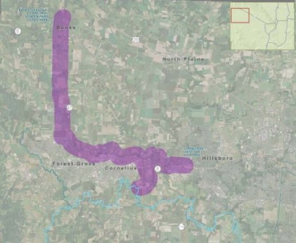
The farmland west and north of Hillsboro would get a 15-mile off-road paved path connecting the Hillsboro Central MAX station directly to the Banks-Vernonia Trail, making one of the region’s easiest bike-to-nature trips even easier, under a plan that’s starting to roll forward this month.
Planners will sketch possible routes for the future Council Creek Regional Trail at an public open house in late spring or early summer, Forest Grove civil engineer Derek Robbins said in an interview Wednesday.
“It’s going to be huge,” Robbins said. “Everybody’s going to want to come over to ride their bike.”
Like other regional trails, the path will vary from 12 to 14 feet wide and will be great for walking, running and skating too. In addition to Banks-Vernonia, it’ll link users to the Crown-Zellerbach Trail that connects the Vernonia area to the Scappoose area, and maybe one day to the proposed Salmonberry Corridor to the Oregon coast.
Here’s a general description of the route from a relevant planning document, which would also be likely to connect with Cornelius and Forest Grove, creating an excellent east-west bike commuting route through Washington County.
The corridor lies astride a single major east/west road, Highway 8, which runs from Beaverton, through Hillsboro, and Cornelius to terminate in Forest Grove. Highway 8 is basically a 4 lane facility with sections of dual, 2 lane couplets in the cities. Level of service on Highway 8 remains acceptable, except during peak hours, but continued growth will eventually lead to congestion. Expansion options are limited, as there are no other continuous east/west streets in the corridor. Highway 47 runs north/south through Forest Grove and into Banks, and could potentially cross the corridor.
The corridor is also near two railroads. The railroad line north of Highway 8, which has the closest tie to this corridor, is the former Oregon Electric Forest Grove Branch, which runs from Hillsboro to Forest Grove and the ROW is owned by ODOT. Only minimal local freight is currently operating. The Forest Grove Light Rail extension is currently being planned in this ROW.
The planning so far is being paid for by federal flexible transportation funds. There’s no funding source associated with the construction itself yet, a $104 million endeavor that Robbins expects will happen in phases.
“There’s lots of opportunities and lots of options,” Robbins said.


