
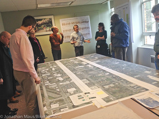
committee members answered questions
at their Tuesday meeting.
(Photo by J. Maus/BikePortland)
If all goes according to plan, your experience riding north on N Williams Avenue will be much different by the end of this summer. After a long and winding public process, PBOT is close to finalizing a design and going to construction on a significant re-design of Williams Ave between Weidler and Killingsworth. At a meeting Tuesday, city staff and members of the project’s stakeholder advisory committee shared details and answered questions on both the Williams project and a companion project that emerged as a priority during the public process — a neighborhood greenway on N Rodney.
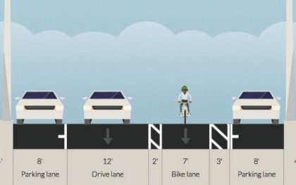
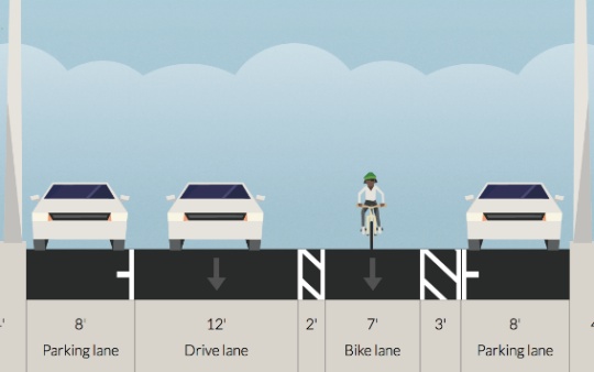
As we’ve covered recently, there are two basic cross-sections PBOT will deploy on the 40-feet of right-of-way available on Williams.
For most of the length of this project, the new design for Williams comes with a generously-sized bikeway on the left side of the street, one standard vehicle lane (there used to be two), two lanes for on-street parking, and several upgrades like a new traffic signal (at Cook) and new curb extensions and crosswalks. Specifically, the dominant cross-section will be an eight-foot parking lane, then a 12-foot bicycle lane (which consists of a three-foot buffer for car doors, then a seven-foot bike lane, then another two-foot buffer to the adjacent lane), then a 12-foot standard vehicle lane, then another eight-foot lane for auto parking.
To put it another way: Of the total 40 feet, 16 feet will be dedicated to parking cars, 12 feet is set aside solely for the operation of bicycles, and 12 feet will be used (mostly) by cars, trucks and buses.
Here’s a visual I mocked up using Streetmix:
Compared to the current five-six foot bike lane that exists now, the new design will make for a more pleasant riding experience — even if it’s not the curbside, protected cycle-track some hoped for at the outset of this process.
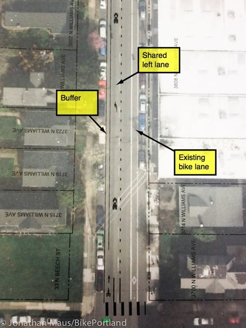
However, in the blocks of Williams with the most restaurants, housing, and other destinations, PBOT drops the one bike lane/one standard lane configuration in favor of two standard lanes and no bike lane. PBOT’s rationale (a.k.a. what the national level-of-service guidelines tell them) is that two standard lanes are needed in this section in order to maintain expected auto capacity. This change begins between N Fargo and Cook, just south of the new New Seasons Market. North of Fremont, the bike lane buffer is removed, then north of Beech, the bike lane is gone completely and all that’s left is a sharrow marking. This shared environment continues for about four blocks (until N. Skidmore Ave.).
Here’s how that shared environment will look:
At first this design had me very concerned. I felt it was another example of PBOT bowing to outdated, auto-centric level of service guidelines (which many feel should be repealed entirely). But upon further examination and discussion with PBOT staff at the meeting, I’m a little more positive about the design. Here’s why: Yes, these 3-4 blocks through the busiest, most interesting section of Williams will not have dedicated space for bicycling and people on bikes will be in a shared environment with people driving cars. And yes, PBOT’s design was influenced by auto capacity standards that run counter to every planning goal we’ve adopted; but there are reasons to expect (and hope) that the left (shared) lane will be primarily for cycling traffic and will be only sparingly used by drivers.
Several PBOT engineering staffers at Tuesday’s meeting said they will try to use signage, pavement markings, and other design cues to clarify that people driving cars should only be in the left lane if they intend to park or turn left.
At the start of each block in these shared-lane sections, there will be some sort of median similar to what’s shown in the mock-up below…
This physical infrastructure (it will be either a paved and/or planted median) should provide a strong visual cue that the space beyond it is not a standard lane. PBOT is still finalizing exactly how to “beef up the look of that throat” (in the words of one engineer), so if you have ideas, feel free to share them. There will also be sharrow pavement markings and some sort of signage to drive the point home. It’s also worth noting that the left lane in the two-lane sections is a left-turn only lane. In other words, while technically it’s a second lane that you can drive on, PBOT says they’ll do whatever they can (design-wise) to limit auto traffic in the left lane.
While I’m hopeful the design will work, just how people behave in this busy four-block section remains one of the largest and most important unanswered questions of this entire project. If people drive dangerously and inconsiderately in this section it could vastly undermine the central goal of the project — which is to improve safety. Given the dense land-use, the left-turn only stipulation and design cues, I hope/expect auto traffic will be very light and tame in these sections — but we’ll have to wait and see how people behave in real life.
Another thing to keep in mind is that there are hundreds of new residential units and thousands of square feet of retail frontage being built/planned in this section (near Skidmore), so it’s absolutely crucial that we get the street environment right.
And this design could have ramifications for how PBOT handles bike traffic in other dense commercial districts. Thus far, they have been very reluctant to use shared-lane markings (a.k.a. sharrows) outside the safe confines of neighborhood greenways. Sharrows on busy streets, the thinking at PBOT goes, could send the wrong message to families and novice riders who expect them to symbolize low-stress conditions. Putting sharrows on a major road like Williams is a big step for PBOT and — if it goes well — could influence other projects in the future.
One last thought (for now) about the new look of Williams is that left-side bike lanes are new to Portland. This will be one of the busiest bike streets in the city with one of the most unique engineering treatments. That could lead to chaos until folks get used to it. Stay tuned.
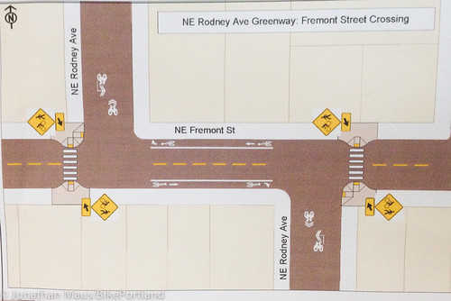
Speaking of chaos, the crazy traffic situation on Williams is what spurred PBOT’s plans for a neighborhood greenway on Rodney, a north-south street just a few blocks to the east. On Tuesday, PBOT shared its plans for Rodney for the first time.
Once the project is complete, Rodney will have the same features — speed bumps, bike network wayfinding signage, 20 mph speed limit, and sharrows — that we’ve come to expect on neighborhood greenways. In addition to those standard elements, six intersections will get special attention: Russell, Fremont, Shaver, Skidmore, Alberta, and Killingsworth.
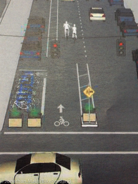
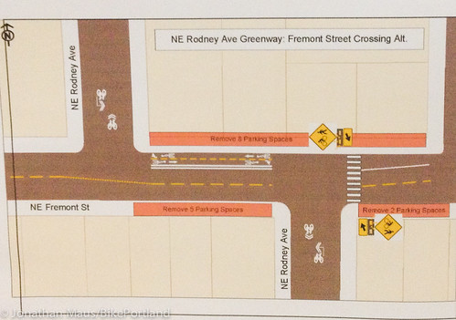
The most significant crossing treatment will happen at Fremont, where PBOT must grapple with a tricky off-set intersection. They’re currently looking at two options: adding curb extensions, bike lanes (on Fremont) and a new crosswalk;
or adding a flashing beacon and a two-way cycle-track on the north side of the street (similar to the Going/33rd intersection).
According to project manager Rich Newlands, there will be an open house in April to garner more public input on the Rodney plans.
Both the Williams and Rodney projects are funded and are expected to be fully completed by the end of this summer.
We’ll have more coverage as plans and construction timelines become finalized.