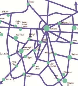
as envisioned in Metro’s plan.
Metro will host an open house tomorrow (5/23) for their Regional Active Transportation Plan. The plan will be the region’s first specifically tailored to bicycling, walking and access to transit. The planning effort has been underway for well over a year and is set to wrap up by the end of next month. In summer of 2014 the plan’s recommendations and a list of prioritized projects will be proposed for adoptions into the Regional Transportation Plan.
The plan’s ambitious scope includes: the creation of a new set of design guidelines for bicycle facilities; an update to regional biking and walking maps; integration of the existing active transportation network; identification of a network of ‘Regional Bicycle Parkways’; a recommendation of strategies for implementation, and more.
In other words, this is a big deal. As its projects get adopted into the RTP, Metro’s Regional Active Transportation Plan will give regional policymakers the crucial political breathing room and decision-making framework they need to make real and significant investments that could vastly improve bicycling conditions.
In developing the plan, Metro created an existing conditions report that laid out the massive potential and challenges our region has for realizing a transportation system that is more oriented toward bicycling and walking. Here are some of their findings (taken from their own Household Activity Survey, the State of Safety report, and Opt-In survey results):
- bicycling is growing at a faster clip than any other mode in the region;
- of all the bike trips made in the region, 58% are made by people with an income of $75,000 a year or less;
- 75% of our region’s bike trips are made by “white persons” and 25% are made by “non-white persons”;
- however, “non-white persons” make a larger percentage of their trips (3.3%) by bike than “white persons” (2.7%);
- women make 35% of all bike trips in the region;
- about 59% of all auto trips in the region are under three miles;
- only 34% of all bike trips are for work, while 53% are for social events, errands, or recreation;
- while 18% of all trips in the region are made by bicycling and walking, they get only 3% of capital transportation funds;
- Portland has 68% of the entire region’s serious bicycle crashes;
- over 52% of all bicycle crashes occur at intersections;
- an average of 88% of survey respondents from Clackamas, Washington, and Multnomah said they are either “somewhat” or “very” interested in biking more often for transportation.
To develop the regional active transportation network, Metro kept the above findings in mind and overlayed them with a list of over-arching principles (like making facilities safe, connected and easy-to-use) and an evaluation criteria. The four main evaluation criteria were: access, safety, equity, and increased activity (as in, does the network increase the number of bike/walk trips).
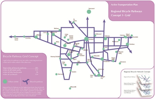
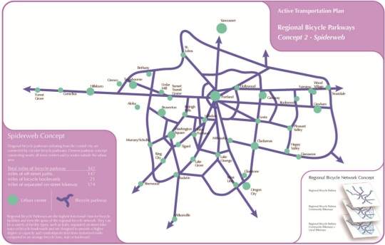
At the City of Portland Bicycle Advisory Committee meeting last month, Metro’s Lake McTighe, a project manager in their active transportation department shared the three “network concepts” they have come up with in order to model performance against the criteria. The three concepts (see below) are made up of “Regional Bicycle Parkways” which Metro describes as, “the highest functional class for bicycle facilities” that “form the spine” of the network.
There’s the “Grid” concept:

The “Spiderweb” concept:

And the “Mobility Corridors” concept:

Metro analyzed each of the concepts to determine how each one influenced the rate and nature of bike trips. Another important part of this plan is Metro’s use of a bicycle traffic demand model. This is a big deal because transportation planners have never had a way to test how different types of facilities impact bicycle traffic. Auto traffic demand models are very sophisticated and they dominate transportation planning as a result. Metro has been working with researchers at Portland State’s Oregon Transportation Research Education Consortium (OTREC) to create the model and it’s finally starting to bear fruit. McTighe says they can now use the took to “look at how bike project might create new bike trips, change trips from driving to biking” and so on.
Another tool Metro is rolling out in this plan is the “Bicycle Comfort Index”. This tool can also give them a more sophisticated understanding of how different network concepts and facility types will impact the rate and nature of bicycle use. They use auto speed, auto volume, and the number of lanes on a roadway to determine a route’s BCI value. “We’re interested in getting at that 60% of people that are “interested but concerned” so it’s about understanding that the existing of a bike lane isn’t enough to make people feel comfortable bicycling. We’re not just saying, ‘OK, we’ve got a bike lane so we’re done.'”
All this analysis can tell Metro where the high demand routes are and whether or not those routes are comfortable to bike on. If they find a high demand route with a low comfort index score, a project that improve bicycling on that route could be bumped up on the priority list. (One of the interesting findings so far is that diagonal routes, regardless of whether a bike lane is present or not (like Sandy Blvd), show high bicycle traffic demand.)
There’s a lot more to this plan than I’ve outlined. Before you go to the open house tomorrow, your homework is to check out the PDF of McTighe’s presentation to the Bike Advisory Committe last month. I also asked McTighe this morning what she’s most interested in in terms of feedback. She said they are still developing the recommend networks and how projects should be prioritized and she shared a list of questions they’d like your answers to:
- How complex and dense should the regional bike and pedestrian networks be (keeping in mind that we want to prioritize and focus investments)?
- How important is the quality of the experience (quiet, comfortable, green, wide path) compared to utility (directness of route, ease of reaching destination)?
- What is most important when considering location routes: nature beauty (near trees, rivers, and so on); direct access to shops and restaurants and services; separation from traffic; complete protection from traffic even if taken somewhat out of direction; avoiding hills?
- What are the highest priority projects people would like to see built?
Be there:
-
Regional Active Transportation Plan Open House
5 to 7 P.M. Thursday, May 23
Metro Regional Center, Council Chamber (600 NE Grand Ave)

