
Portland Parks and Recreation has posted maps of the proposed alignment (PDF) of the North Portland Greenway Trail along with an online comment form to gauge public feedback about the routes. The City has been working with an advisory committee since January to come up with the precise alignment for the future 10-mile path that will connect the north end of the Eastbank Esplanade (near the Steel Bridge) to Kelley Point Park.
Reviews on the proposed alignment are coming back mixed. While there’s excitement to see progress on this project, I’ve gotten several emails of concern about the path’s southern segments. Below I’ll take you through the alignment maps and then share the concerns I’ve heard. (Please note: The orange dotted line is for a different trail project.)
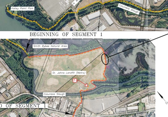
The proposed route begins by winding south through Kelley Point Park and Smith and Bybee Lakes on bike (and walk) only paths…
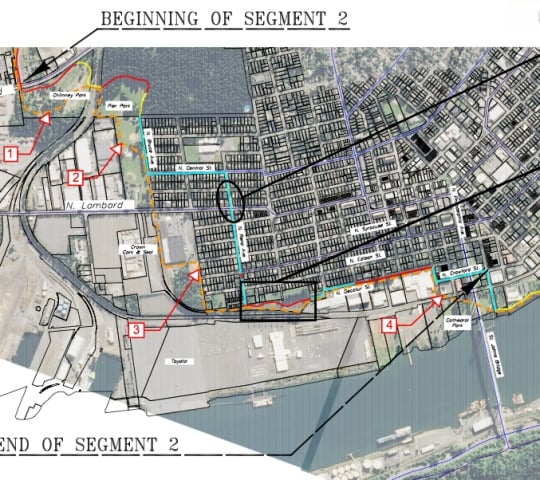
Then, the plan would be to use residential streets in St. Johns to get to the Willamette Riverfront near Cathedral Park under the St. Johns Bridge…
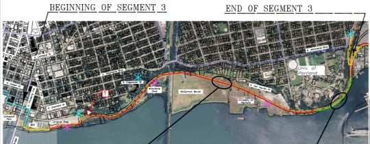
After that, the path would continue along the river, winding around the point at University of Portland’s campus with a “boardwalk”…
The pathway would then continue onto Swan Island with a separated path on N. Basin Ave. And this is where things go a bit sour. Instead of continuing directly south from Basin and connecting to the river via existing paths, city planners are proposing to take the route up onto surface streets via N. Going Street…
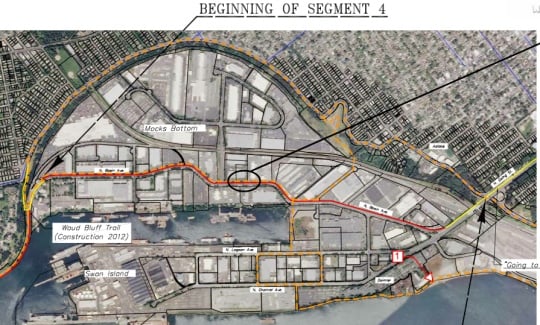
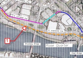
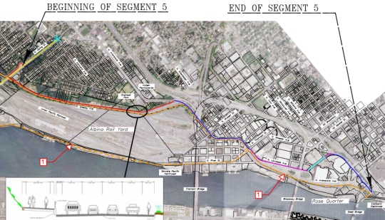
From N. Going, the route would take people onto a separated path on N. Greeley Ave, onto existing bike lanes on N. Interstate Ave, then left via a new two-way cycle-track on N. Larrabee, across Broadway and then through the Rose Garden to the existing bikeways in the Rose Quarter Transit Center…
Reader Max D. wrote in today about the alignment proposal and called the section from University of Portland to the Rose Quarter, “largely hacked-in along roads.” Max realizes putting the path right on the river isn’t always an easy proposition; but in his opinion, the plan, “lacks vision and backbone.” “I fear that that a weak, watered-down, convoluted trail alignment that is still just a concept gets the project off on the wrong foot!” he wrote.
“[The trail] needs to be along the Willamette River, especially where the trail is already in place!”
— Lenny Anderson
Lenny Anderson, who heads the Swan Island Business Association and whom by all accounts could be considered the Godfather of biking and walking on Swan Island given his role as founder and former director of the Swan Island Transportation Management Association, is also not pleased with the alignment proposal.
Anderson wants all further considerations and planning of the route past the point where Basin Ave intersects with N. Emerson/Ballast Streets (about mid-way through Segment 4) to stop immediately.
Instead of continuing south on Basin Ave, Anderson wants to see the route head west toward the river via Ballast Street (along a brand new “River to Lagoon Trail” being dedicated tomorrow (9/21)) and follow the already adopted North Reach River Plan Trail alignment. He says it’s just common sense to use the existing, one mile of the Greenway Trail that has already been built.
“The goal should be to get to the existing facilities… [the trail] needs to be along the Willamette River,” says Anderson, “especially where the trail is already in place!”
The existing path along the river ends a few tenths of a mile south of Going St. From there, Anderson would like to push to make the “Ash Grove Cement Road” the preferred alignment. That road is currently private right of way owned by Union Pacific Railroad that connects directly to N. River Street and Interstate/Larrabee at Tillamook. It’s often used by Swan Island bike commuters and others and trespassing is rarely enforced.
“Just drop any further work in section 5,” Anderson says, “until the city, state, and federals work something out to make the existing “Ash Grove Cement Road” a public facility, providing a vital second access to Swan Island and making the preferred trail alignment possible.”
——
We’ll be following this story as the plans evolve. For now, please take some time to view the alignment maps (PDF) and take the online survey to give your feedback to PP&R. The deadline for comments is September 26th.
You can also contact project managers Sarah Huggins at sarah.huggins@portlandoregon.gov or Emily Roth at emily.roth@portlandoregon.gov.
— To learn more about biking on Swan Island, join Lenny and lots of other fine folks down there tomorrow morning for free breakfast, trail dedications, and more. Get the details here.