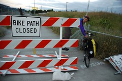
This morning’s news that the Morrison Bridge multi-use path will be closed to both directions of bicycle traffic from this Monday until mid-September, was just the latest in a string of closures that impact vital connections in our bikeway network.
This post will hopefully serve as a reference for the current closures and as a place to share your experiences with the detours.
Thanks to reader Esther Harlow, below is a handy map to give you a perspective on how close and interconnected the closures are. Below the map, is more information on the four closures:

Here’s a list of the closures:
- Morrison Bridge multi-use path (closed from 6/13 to mid-September): The path will be closed for a construction project that will replace the lift span. The closure starts Monday June 13th and is expected to last until mid-September.
- Eastbank Esplanade – Floating Section (estimated opening June 15th): The floating section of the Esplanade between the Burnside to the Steele Bridge has been closed by the Portland Parks & Recreation Bureau due to high water on the Willamette.
- Waterfront Park south of Steele Bridge (closed until Monday, 6/13): The U.S. Navy, who has ships in dock for the Rose Festival, has closed a section of this path due to security concerns (which they’ve done every year since 2002). Please note that the Steele Bridge lower deck is still open and you should be routed onto SW Naito. Also note that when the ships sail out on Monday, expect 15-25 delays for bridge lifts.
- Esplanade near OMSI (closed through 6/24): TriMet has extended this closure so crews can begin preliminary construction of the Portland Milwaukie Light Rail Bridge. The Esplanade is closed between SE Clay and Caruthers. The detour takes you onto SE Water Avenue. (See map here)
Many readers have expressed frustration about these closures. Having to find alternate routes when there aren’t redundant safe access options for bike traffic like there is for cars is one thing; but we’ve also heard that the lack of signage around these detours is making things even more difficult.
One of the problems at play is that several different agencies have management authority over these bikeways. Portland Parks & Recreation manages the Esplanade and Waterfront Park (with some coordination with PBOT), Multnomah County controls the Morrison Bridge, and TriMet manages the light rail project.
When you mix multiple bureaucracies together with a culture that doesn’t always fully respect bicycle traffic (to the extent it respects auto traffic), you get a situation where mitigation for bike traffic impacts isn’t taken as seriously as it should be.
Detours and closures that impact bikeways aren’t new and they’ll continue to become an issue as bicycle use increases. Perhaps it’s time for a citywide ordinance that calls for minimum, bike-specific requirements for detour signage and closure mitigation practices?
What do you think? Please chime in and let us know what you’re seeing out there and how these detours are impacting your ability to get around.


