

However you feel about TriMet, say this for Portland’s transit agency: They might be better than anybody in the world at putting their bus and train schedules in your hands.
Since BikePortland last checked in on TriMet’s online trip planner, it’s become the most popular Portland-specific search on the Internet and it has unleashed an army of web and smartphone apps — all which have been built at no public cost. Now the agency’s trend-setting map team is working on the “holy grail”: an open-source multi-modal planning tool using the General Transit Feed Specification.
Or, in English: TriMet is about six months away from being able to tell you – and anybody else who might want to know – when it’d be faster to hop on the MAX for part of your crosstown bike trip.
Suffice it to say, Portland’s transportation geeks are very excited.

(Photo: Michael Andersen)
About 40 local transportation and data experts showed up yesterday to see one of the first demos of their new Open Trip Planner.
“We should have sold tickets!” Metro planner Daniel Kaempff quipped to the standing-room-only crowd that heard a presentation by TriMet’s IT Manager Bibiana McHugh, and Michael Keating from Open Plans, a non-profit, open-source software company (the same non-profit that funds and provides software for Streetsblog).
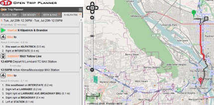
The Open Trip Planner — which was paid for by a $69,000 grant from Metro’s Regional Travel Options program — is still a work in progress, but you can already kick the tires on their test site.
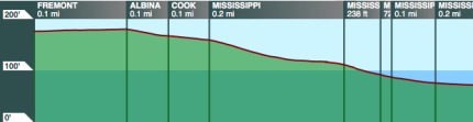
See that panel that opens in the lower right when your trip involves bicycling? That’s a cross-section of the hills on your route, courtesy of the U.S. Geological Survey, mapped against every turn you’ve got to make.
See that “quickest route/safest route” dropdown? That’s a trick TriMet picked up from ByCycle.org, the local site whose creator Wyatt Baldwin was hired by TriMet’s maps team in 2008.
“Anything is possible. We’ve got the richest, most valuable data in the world here. I think this is the place to do it.”
— Bibiana McHugh, TriMet IT Manager
But here’s the thing that’s got good-government types excited about the project: both the tool and its API will be entirely open-source. That means that once TriMet and its partners finish their work, agencies around the world will be able to use it – and keep improving it – for free. And third-party developers will be able to use it for smartphone apps nobody’s dreamt of yet.
“It’s going to be used all over and have support from all over,” predicted Aaron Antrim of Trillium Solutions, a Portland-based multi-modal transportation information consultant.
Already, transportation software developers in New York City, Poland and Spain have been pouring time into the project in hopes of putting it to work in their own cities. Thanks to their help, McHugh said, the project is six months ahead of schedule. She thinks it’ll be ready for public beta-testing in early 2011.
The crowd at Tuesday’s event was brimming with ideas for the next generation of online trip planning.
- Could a trip planner let a TriMet rider tweak her morning commute to her exercise regimen – say, a 5-mile bike ride Tuesday and Thursday, with a 10-mile ride on Wednesday?
- Could a salesman enter a list of addresses to calculate his most efficient route around downtown?
- Could a green-minded family compare the carbon footprints of every possible crosstown trip, pound for pound?
- Could Amtrak plug in its own arrival data? What about Greyhound?
McHugh, the TriMet manager, is optimistic. She’s encouraged by Portland’s recent efforts to unleash reams of its internal government data on the Internet. “Anything is possible,” McHugh said. “We’ve got the richest, most valuable data in the world here. I think this is the place to do it.”
What trip-planning tricks can you dream up? You can bet TriMet and an enterprising flock of private app developers are watching.
This article was written by Michael Andersen, founder of recently launched Portland Afoot. Email him at Michael@PortlandAfoot.org or follow @PortlandAfoot on Twitter.