(Photo: Matt Menely)
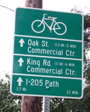
The City of Milwaukie (which borders Portland to the southeast) has installed its first of 212 bikeway network signs. Milwaukie resident Matt Menely spotted the first one, which is located near SE 28th and Monroe.
The Bikeway Signage Plan project began with a series of public meetings in February 2009 and the signs are a part of Milwaukie’s Bike Plan which was adopted by City Council in December 2007.
The installation will be done in three phases and the first phase includes 48 signs. According to City of Milwaukie planner Brett Kelver, they have $10,000 allocated for the first 40 signs. The signs cost $250 (fabrication and installation) each and money for the project comes from a fund for biking and walking projects set aside with 1% of Milwaukie’s state gas tax revenues. The signs are similar in style to signs the City of Portland began installing back in late 2005.
What’s the purpose of the signs? Here is a list of benefits as laid out in the Milwaukie Bicycle Wayfinding Signage Plan (which was developed by Alta Planning):
Signage can serve both wayfinding and safety purposes, including:
- Helping to familiarize users with the bikeway system;
- Helping users identify the best routes to significant destinations;
- Helping to address misperceptions about time and distance;
- and Helping to overcome a “barrier to entry” for people who do not bicycle often, but who want
to get started.
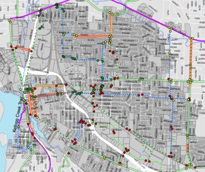
Below is a detail of a map showing all the locations (the purple line to the north is the Springwater Corridor Trail):

More information on this project at the City of Milwaukie website.