–Watch slide presentation below–
Alta Planning and Design and the City of Portland’s Office of Transportation have collaborated to develop “Cycle Zone Analysis”, a powerful new modeling tool that could have a significant impact on how Portland plans its future bikeways.
PDOT’s bike coordinator Roger Geller presented the Cycle Zone research and methodology at the International Symposium on Walking and Biking in Seattle back in September. He also shared the work with a packed room of Portlanders during PDOT’s monthly Bicycle Brown Bag discussion series last week.

at a lunch-hour lecture series last week.
(Photo � J. Maus)
Geller explained that he and his partners on the project have identified 32 distinct “Cycle Zones” within the Portland city limits. The zones — which are defined by areas where similar bikeway conditions exist — were created through a combination of professional expertise, feedback from the City’s bike advisory committee, and from public input during open house events.

Why create Cycle Zones? Geller says the zones help them in a number of ways: they give planners a more “fine-grained” understanding of how cycling conditions differ through the city; they allow more custom-tailored solutions; they help PDOT figure out what locations have the most potential to create “world-class cycling conditions”; and they help organize and direct discussion about biking conditions in general.
To analyze the zones, Alta Planning and PDOT looked at factors ranging from the existence of barriers (like major streets or freeways) to how hilly an area is.
One of the key tools developed as part of the Cycle Zone work was a new way to rate bikeway conditions — the Bikeway Quality Index (BQI). The BQI is a relative measure of the quality of existing bikeways in a particular zone. It’s based on looking at 10 different variables (like width of the bike lane, automobile speeds, dropped bike lanes, etc…) and each of the seven levels corresponds to a different color (see graphic at right).
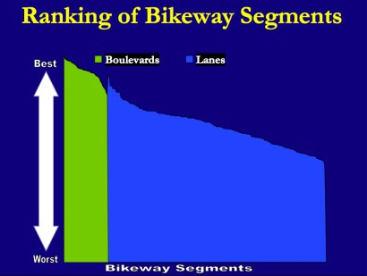
Using the BQI, Geller says they discovered further evidence to explain why bike boulevards (low-traffic streets where bikes are prioritized) should be the focus of their efforts over the installation of bike lanes. The slide below shows that, when overlayed with the BQI tool, nearly all of Portland’s bikeway segments that are classified as bike boulevards are ranked higher than even the highest-quality bike lanes.

Looking at the slide above, Geller said:
“This is one of the reasons why we are focusing on creating more bike boulevards, because generally the cycling experience is better on boulevards than on bike lanes. We’re not going to stop installing bike lanes, we just want to see bike boulevards be a more prominent element in our system.”
So, how does your Cycle Zones stack up? Here are the overall rankings of all 32 Cycle Zones, once all the factors (slope, land use, density, etc…) have been weighed in:

As you can see, the areas with the highest ratings (purple) have high density (both commercial and residential), and a complete grid network of streets (among other similarities).
This research gives planners a way to assess which areas have the most potential to improve biking conditions. It can also help guide them in making decisions on specifically what factors need to be improved to reach that potential.
Here’s an example of how existing conditions dictate the potential quality of the bikeway in different cycle zones. In the slide, the green shading is where their are significant hills, the white lines are streets, and the pink boxes are commercial nodes.

Not surprisingly, the area with the most intact and connected street grid, combined with commercial density has the best potential, while the zone with hills, windy streets, and a long distance from residential to commercials areas has the worst potential.
In the case of the high potential area, the strategy would be to create what PDOT is calling a “Bicycle District” (they�ve got one planned for the Pearl District already). In the case of the low potential area, the strategy would be to work on connecting gaps in the network. Here’s a slide that shows more examples of how existing conditions might dictate strategies to improve them:

Mia Birk, the former bike program manager at PDOT who�s now a principal with Alta Planning, says several other cities are interested in applying the Cycle Zone Analysis and Bikeway Quality Index to their bikeway networks.
This new tool will be an important part of PDOT�s ongoing Bicycle Master Plan Update effort, and it�s also a very promising development for bike planners in general.
Modeling of different external factors is a tool that drives almost every transportation infrastructure funding and urban planning decision. Highway and transit planners have very sophisticated modeling tools that allow them to make their case to decision makers (or at least help make an informed decision). Having a similar tool for bikes, is a very important step toward leveling the playing field.
====
For a more detailed look at Cycle Zone Analysis, sit back and wonk out to the audio slideshow below. I recorded Geller�s presentation (planner Denver Igarta is also featured) and mixed it with the slides (you can also download the slides as a PDF):

