
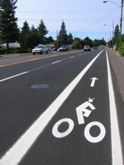
(Photo by Jeff Smith/PDOT)
The City of Portland Office of Transportation (PDOT) has completed the installation of 1.6 miles of bike lanes in Outer Southeast Portland.
The new lanes are on SE 162nd Avenue from Powell to Stark and they create a continuous route of over three miles of bike lanes all the way from the I-84 path south to Powell. PDOT’s current bike map of Outer Southeast shows this portion of 162nd as a “difficult connection”, so these new lanes are a welcome improvement.
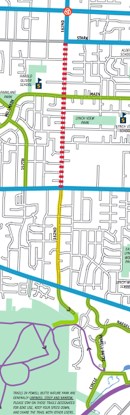
of SE 162nd. Notice
“difficult connection” symbol
and Powell Butte and
Springwater Trail
at bottom.
(Map: PDOT)
PDOT’s Jeff Smith also points out that this bike lane helps make a great connection to Powell Butte and further south to the Springwater Corridor Trail.
I rode this stretch during a tour of East Portland with the City’s Bike Advisory Committee back in July and, even though 162nd is a large street, the bike lane added a significant level of comfort. Smith offers a reason why:
“The traffic on the south end of 162nd is considerably lower than the rest of the street, and the land use is largely low-density residential, so it really makes for a fairly pleasant ride.”
PDOT hopes new connections like this encourage more East Portlanders to consider biking. “There doesn’t seem to be a lot of cyclists out there yet,” says Smith, “but i think with time they’ll find it.”