
PDOT’s Transportation Options Division specializes in individualized marketing programs that help make it easy for Portlanders to choose to walk, bike, or take transit.
Each year, they take one section of the city and do an outreach and education blitz that includes free gifts, workshops, events, incentives, and more. They’re currently focusing on southeast Portland with their SmartTrips Southeast program. Usually their work stays within Portland borders, but this time they’re expanding their reach.
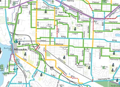
Thanks to a grant from Metro, PDOT’s SmartTrips Southeast target area also includes 3400 households in the city of Milwaukie. As part of the program, they’ve completed their first-ever bike map of Milwaukie.

Click for full version (PDF 695 KB).
Portland is connected to Milwaukie by not only by the Springwater Corridor Trail (bolstered recently by three new bike/ped bridges), but by the scores of cyclists who commute between the two cities each day.

at Breakfast on the Bridges.
File photo: 2/13/07
One of them is Matt Picio. Matt is a regular at many local bike events and is an active volunteer in the community. As a Milwaukie resident he has been highly involved with the bike and pedestrian planning portion of their Transportation System Plan Update.
Matt has been posting detailed reports and photos from City of Milwaukie planning meetings and he has even led rides to illustrate the highs and lows of Milwaukie’s bike network.
This new map, the completion of the Three Bridges Project, and the energy from people like Matt are exciting developments in making our region a better place to ride.
We’ll all have a chance to bask in the the Portland-Milwaukie bike love on May 19th at the Three Bridges Opening celebration!