
[Then]

[Now]
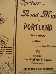
One reason Portland is such a great biking town is that bikes have been a part of the landscape for well over 100 years. Case in point; in my office I’ve got a framed version of the “Cyclists’ Road Map of Portland” dated 1896 (more photos here). It’s a really cool map and it has advertisements for all kinds of interesting things including:
- Shirk Bicycles which are “strictly up-to-date”
- Sterling Bicycles formerly located at 362 Morrison Street
- “Women’s and Men’s Bicycle Hose, Shoes and Caps for sale at Meier and Frank; “decided by women everywhere to be the most convenient and serviceable wheeling apparel made”
Compare that to Metro’s current Bike There! map and you can see how far we’ve come in 110 years.
For another interesting look at the progress of Portland’s bikeway network, check out this animation I created. It shows the bikeway network in 5-year increments from 1980 and into the future.