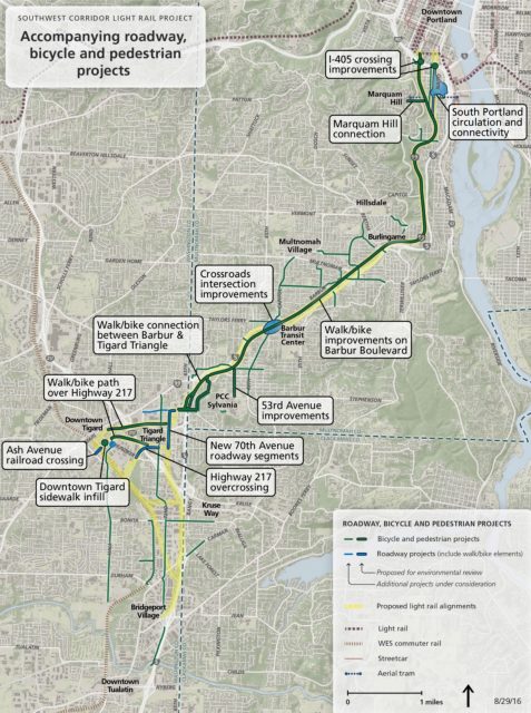
Metro is moving forward on the SW Corridor, a project that aims to build a new, 12-mile long light rail line that will connect downtown Portland to Tigard and Bridgeport Village.
The project is currently in its scoping phase and today is the final day to submit feedback on which projects should be included. This scoping phase is part of the federally mandated process to produce a Draft Environmental Impact Statement. As part of that statement the project organizers can include complementary projects that the project will be able to address in the coming steps of the process. Put another way, if your favorite project — for instance protected bikeway on Barbur adjacent to the new MAX line — isn’t included in the Draft EIS, it won’t even be on the table.
After years of planning Metro has queued up 36 addition biking and walking projects that are under consideration to include in the Draft EIS (you can review them all in this PDF). Here are a few of them:
Advertisement
Naito Parkway to Hooley Bridge bikeway
This project would create a two-way shared street bikeway on Grover Street, Corbett Avenue and Gibbs Street to connect a light rail station at Naito Parkway and Grover Street to the Darlene Hooley pedestrian and bicycle bridge over I-5.Chestnut Street Bikeway
This project would restripe SW Chestnut Street to create a westbound bike lane (uphill) and an eastbound shared street bikway (downhill) between SW Vermont Street and SW Terwilliger Boulevard.Pedestrian/bicycle bridge over I-5 near Custer Street
This project would construct a new crossing over I-5 for pedestrians and bicyclists near the proposed light rail station on Barbur Boulevard between SW Custer Street and SW 13th Avenue. The bridge would connect to SW 11th Avenue and SW Canby Street at the north end of Burlingame Park, and provide a street light in this location. The need to construct water quality facilities is anticipated.
Metro is asking specifically for input on: “What are the most important factors for decision makers to consider when deciding which additional roadway, bicycle and pedestrian projects to study in the Draft EIS?” and, “Are there any additional projects that would provide improved access to a proposed light rail station that should be studied in the Draft EIS?”
You can also make your voice heard by taking a survey. There’s a short and long version depending on your time and level of interest. The short one takes about five to seven minutes and the long one takes about 20 minutes. Email is another option to share your feedback. Send your comments to swclrt.scoping@oregonmetro.gov. Surveys and all other scoping feedback must be received by 5:00 pm today.
— Jonathan Maus, (503) 706-8804 – jonathan@bikeportland.org
BikePortland is supported by the community (that means you!). Please become a subscriber or make a donation today.


