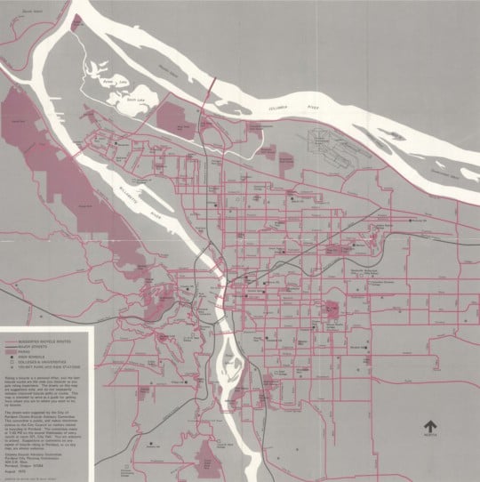
What did cycling routes in Portland look like over 40 years ago? That’s something we’d never known until coming across this “From here to there by bicycle” map.
This map shows a robust network of streets recommended for cycling. It was created in 1975 and the streets were chosen by the City of Portland’s Bicycle Advisory Committee (a committee that still meets today). Keep in mind while you look at it in detail (below) that this map doesn’t necessarily show bike-specific infrastructure like bike lanes. That’s because there wasn’t much of that type of thing on the road yet. Portland had just passed its first bike plan in 1973 so it was at the very beginning of the bike network that would later earn us a place as the undisputed leader for cycling in the U.S.
This is the second-oldest Portland bike map I’ve ever seen. The oldest is the amazing “Bicycle Road Map Portland District” published by Cunningham & Banks in 1896 (and endorsed by the Multnomah Wheelmen).
While the 1896 map is fun merely for its age, what I think’s more significant about this 1975 version is that it was created by the City of Portland. Is it the first ever map created by the bureau of transportation? Perhaps one of our friends from PBOT (hello Jeff Smith!) can enlighten us in the comments.
Scroll down to view the map…
Advertisement
I also love how this map is clearly not intended solely as a utilitarian resource. This is a marketing and promotional piece. Today we call this “encouragement” and in fact PBOT has an entire group of staff devoted to it (called “Transportation Options” and housed within their Active Transportation Division). Besides the eye-catching pink color and the welcoming illustrations of classic 70s era riders on the backside (not wearing helmets!), we know it’s part of a promotional effort because of the text in the map’s legend. Here’s what it says:
Riding a bicycle is a personal affair, and the best bicycle routes are the ones you discover as you gain riding experience. The streets on this map are suggestions only, and do not necessarily indicate improved bicycle paths or routes. This map is intended to serve as a guide for getting from where you are to where you want to be, by bicycle.
Another fun thing about this map is how it helps us gain perspective on how far we’ve come in four decades. There are almost no cycling routes suggested in all of downtown from the Steel Bridge to I-405. And of course the once-possible Mt. Hood Freeway, what is now SE Powell/Highway 26, doesn’t even exist. Southwest Barbur Blvd isn’t there either. On the other hand, some of our most important and popular cycling streets are on there: the North Vancouver-Williams couplet; the Southeast Clinton, Ladd, Madison connection, and so on.
What catches your eye?
If you’re interested in how Portland’s bikeway network has evolved, check out the animation we put together a few years ago with map graphics from PBOT bike coordinator Roger Geller.
— Jonathan Maus, (503) 706-8804 – jonathan@bikeportland.org
BikePortland can’t survive without subscribers. It’s just $10 per month and you can sign up in a few minutes.


