
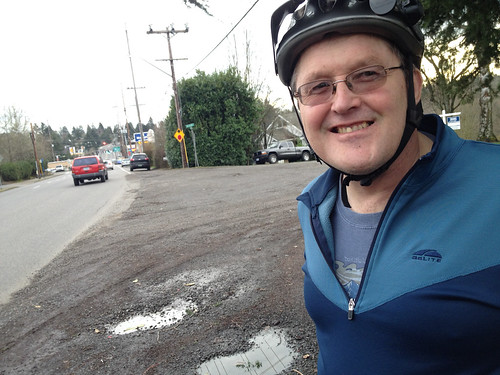
(Photo J. Maus/BikePortland)
This post is part of our Southwest Portland Week.
For a quarter-century now, neighborhood activists have been pushing to make SW Capitol Highway a nicer place to live, walk, and bike. Yesterday I joined up with local resident and Southwest Neighborhoods Inc Transportation Committee Chair Roger Averbeck for a closer look.
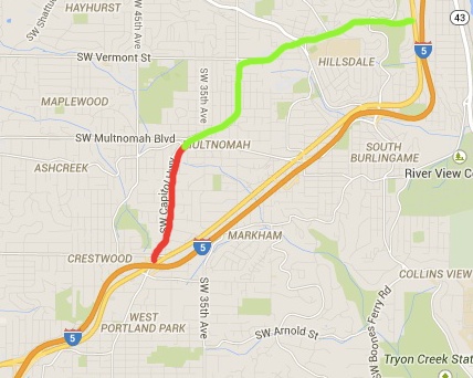
Capitol Highway is only about four miles long, but it’s a key link in the southwest Portland road network. It starts as an east-west arterial in its northern section between Burlingame and Hillsdale, then becomes a smaller, north-south thoroughfare between Garden Home/Multnomah Village and the Barbur Transit Center/I-5 in the south. In doing so it connects thousands of people to a historical business district, schools, a Metro designated Town Center, Portland Community College’s Sylvania campus, and much more.
Southwest Neighborhoods, Inc. President Marianne Fitzgerald has been working on improving Capitol Highway since 1990. She calls it, “the highest priority project for us.” The City of Portland has been chipping away at making improvements to the street since 1996 when City Council adopted the Capitol Highway Plan. That plan was updated in 2011 with the SW Capitol Highway Plan Refinement Report (PDF).
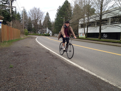
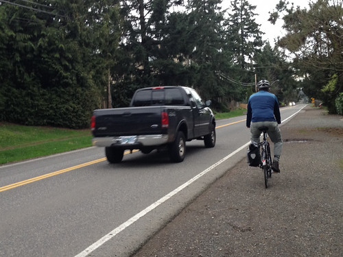
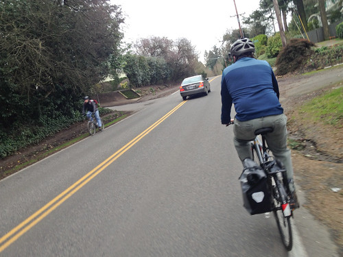
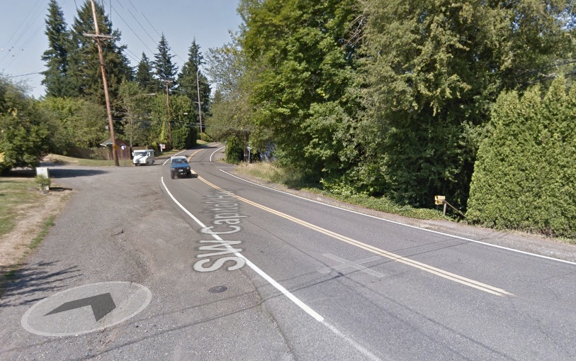
Yesterday, Averbeck and I rode a one-mile section — Garden Home/Multnomah to Taylors Ferry Rd — that still hasn’t seen any improvements. This is a particularly important section because it’s the only feasible north-south biking route in the area. Up until last year it wasn’t even marked as a bike route on the official City of Portland bike map. Now it’s listed in red, the color reserved for the most dangerous routes and which stands for, “shared roadway, very high traffic – over 5,000 vehicles per day.”
During our ride yesterday Averbeck, who lives in Garden Home, said his daughter went to school at Portland Community College just two miles away. Capitol Highway would have been a perfect route. But she didn’t ride. “She was scared to death to bike on this,” Averbeck said over his shoulder as we hugged the fog line and had drivers whizzing past us. “She would never do it.”
Averbeck is about as dedicated as volunteer activists get. He sits on numerous transportation-related committees around town, and has a particular focus on closing gaps on major arterials in southwest Portland. To him, it’s all about getting people to destinations without having to drive. When I mentioned to him how impressed I was with all the parks and greenspaces in these neighborhoods, he had an instant reply. “Yes, they’re nice, but everyone drives to them. Even from close by.”
“Here in southwest,” he continued, “you can walk your dog around the block, but people aren’t able to actually get to any destinations. So we’re trying to fix that.”
Advertisement

And the fix on this section of Capitol Hwy is obvious and straightforward. I was amazed at the existing conditions. Just a two-lane, 24-foot wide “ribbon of asphalt” (to use the City’s term from the report) with no (paved) shoulder, no sidewalks, no bike lanes, and no stormwater treatment facilities.
And here’s the zinger: The actual public right-of-way is 60-feet. That’s enough space to maintain the two standard lanes and add a bike lane and sidewalk on both sides of the street. (For reference, NE Cully Blvd, which has a protected bike lane and on-street parking, is also 60-feet in its newly rebuilt form.)
Currently on Capitol Highway, that 36 feet of unused right-of-way is full of dirt, gravel, trees, shrubs, illegal fences, and parked cars.
Check out where the telephone pole and fenceline are in the photo below. That’s how much excess right-of-way this street has…

Here’s how the intersection with SW Lobelia looks today…
And here’s a drawing of how it could look (image from PBOT’s 2011 Capitol Hwy Plan Refinement Report)…

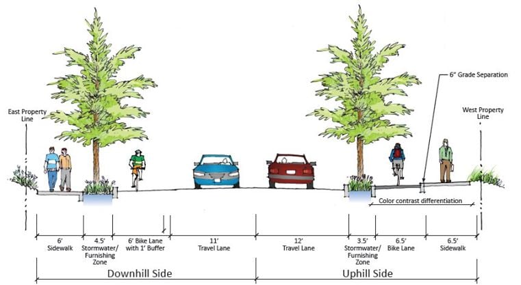
Averbeck says that at a minimum they’d like to see a bike lane in the southbound (climbing) direction and a sidewalk on both sides. But the City’s own plan drawings call for much more: bike lanes, sidewalks, and street trees on both sides.
Here’s a cross-section drawing created by PBOT:
The barrier to progress on SW Capitol Highway, as with many other major projects, is political will and funding (both of which are closely intertwined of course). The funding part is made even more challenging because of tricky stormwater treatments that are mandated by the Bureau of Environmental Services (this is a huge issue that inflates the cost of all southwest Portland projects).
According to the 2011 Plan Refinement Report, the “full build” cost for a project that would install new sidewalks and bike lanes on both sides, would cost $19.1 million — $9 million of which the City says would need to be spent on stormwater management features.
And of course there could be some pushback from neighbors who don’t want the street to change. Averbeck said he’s heard some opposing voices say they want to “preserve the rural character” of the street. “I reply to them by saying, ‘That’s nice, but you no longer have rural traffic volumes,'” he says.
This project is currently on the City of Portland’s Transportation System Plan list (to be built in “1-10 years”); but it lacks a funding commitment or a high-profile champion. Averbeck says it’s hard to create urgency for projects in southwest Portland. At a meeting this week of the City’s Bicycle Advisory Committee, its 20 members were asked to rank their top projects in the TSP. The only people that had ever heard of this project were Averbeck and Fitzgerald.
We’ll be here in Southwest all week. And join us Friday afternoon for a BikePortland Get Together and social hour at the Lucky Labrador Public House in Multnomah Village (7675 SW Capitol Hwy) from 4:00 – 6:30pm.