For months, the Portland Bureau of Transportation has been mum about its ideas for how to spend the $6.6 million for better downtown transportation that has been working its way through the bureaucratic pipeline.
Yesterday, Metro Council approved the plan. So it’s high time we got the serious speculation started — and the map above is a fine place to begin.
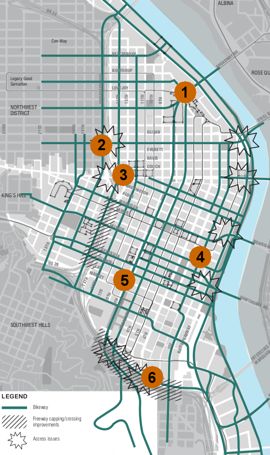
This is map 5d from the city’s West Quadrant Plan, which is planning the future of the area most Portlanders just call “downtown.” It’s focused on which routes and connections the city would prioritize for bike traffic over the next few decades or so. Even though it’s actually a long-term planning document, this map was put together with lots of help from transportation planner Mauricio LeClerc of PBOT, who’s plugged in to the short-term discussions happening behind the scenes at PBOT.
Early this week, I spoke with LeClerc about some of the many interesting details of this map — which, keep in mind, includes many long-term goals as well as possible short-term ones.
Downtown, LeClerc said, “should be a nice place to bike around,” especially with “bikeshare and all the new users that will come with that.” Yet “the bicycle network is the least developed in the west quadrant, in the central city in general” compared to the rest of Portland, he said.
Here are a few details from their long-term plan to fix that.
1) The Broadway Bridge connection.
We noticed two things about this part of the map right away. First, it’s the only downtown crossing that’s not marked as having “access issues.” Though Northwest Broadway’s wide new bike lanes are a big improvement, the connection is far from perfect. Should we be calling the west-side bridge landings the Great Wall of Portland Biking?
Second, the marked bike routes here go straight through a large building … the downtown Post Office. “The Post Office is the Post Office, and they may not want to move,” LeClerc said. On the other hand, they “may want to relocate to the airport,” at least their trucking operation. That’d create some big new possibilities for the Northwest. LeClerc said he’d heard “employment industrial more than residential” discussed for the area. But in the absence of long-term information, the planning office simply drew a line through the property, which has some interesting effects (see No. 5 below).
2) The Flanders crossing of I-405.
Step into your time machine: LeClerc said to make this crossing work, we’ll need a bridge.
“This is a long-term vision,” LeClerc said. “That’s all very expensive, but that’s how we build what we’ve [planned].”
A bridge here — between downtown and the dense neighborhoods of Northwest Portland — was very close to a reality; but after political pressure became too intense, mayoral candidate Sam Adams scrapped the idea in 2008. A new bridge over I-405 is still in the 2030 bike plan, which designates Flanders as the only continuous bike corridor in the area.
3) The Couch crossing of I-405.
Though neither Burnside or Couch is marked as a bike corridor, LeClerc said this tough crossing might finally get some help “very soon” in making it less auto-dominated.
“We got some TIP money to make improvements in that area,” he said. “We will take some of the roads out and install a couple more signals. [At Couch] we’re going to make it more obvious that you’re actually crossing a street.”
4) SW Second Avenue: downtown’s missing north-south bikeway?
If you don’t want to cross Naito and don’t feel like mixing with the absurd traffic behaviors on the transit mall, downtown is not an intuitive place for biking north and south.
LeClerc said a dedicated bikeway on Second Avenue could solve that.
“Fourth has a lot of auto demand and a lot of parking structures, and a lot of demand for right turns onto the bridges, so we thought a bike lane would create a lot of conflicts,” LeClerc said. Second, by contrast, “can get you up from Southwest Portland, but also it can get you access to the bridges and Old Town.”
On the other hand, Fourth Avenue is a popular place to drive for the same reasons it could be a popular place to bike: it’s closer than Second Avenue to many popular destinations and it provides a good connection to the Broadway Bridge. Still, Second Avenue could work.
5) A Park Blocks bikeway?
Remember when Adams was planning a parking-protected bike lane on the North Park Blocks as part of his first 100 days as mayor? Me, neither. But some have thought for years that the Park Blocks could make a great connector — even a car-free space like they are near Portland State University.
This idea is vague — planners simply drew a line down the middle of both the north and south Park Blocks — but it’s too interesting to ignore, especially if it could be a straight shot from the Broadway Bridge to the Powell’s Books area and on south to PSU.
6) Freeway caps.
At a conference last spring, I heard a Florida traffic engineer say Portland will never live up to its mythical reputation until it removes the “noose” of freeways that “choke” its central city. The city has no plans to do that — in fact, it’s looking for ways to invest in the freeway connections in an effort to remove speeding traffic from the streets near PSU — but it is making long-term plans to build “caps” over I-405 at these shaded areas, perhaps as part of the same project.
“It is abstract, but it’s a desire,” LeClerc said. “It’s just filling in a tunnel. You can actually cap something and maintain the mobility underneath. … Reconnecting the PSU area south of downtown to the area just south of it — reconnecting that barrier that the freeway creates — that’s something we would like to do.”

