Clackamas County is updating their Transportation System Plan (TSP) and the time is now to make sure key projects make it into the final version. Getting the right, bike-friendly projects into the TSP is crucial because the plan is the county’s guiding document for investment and planning for the next 20 years. The Bicycle Transportation Alliance is monitoring this TSP update because there are several projects — including the Monroe Neighborhood Greenway that was one of 16 projects in their recent “Blueprint” — that could have a vast impact on bike access in the coming years.
BTA advocate Carl Larson singled out four projects that need support in the Clackamas County TSP update. Check them out below and weigh in via the online “Virtual Workshop” (descriptions below taken from BTA blog post):
Monroe Neighborhood Greenway
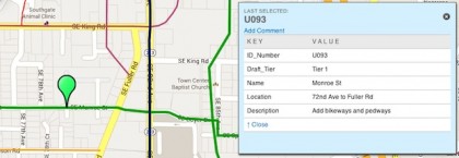
Project U093 in the Clackamas Regional Center / Industrial Area Map
Milwaukie is making exciting progress towards turning SE Monroe Street into a low-traffic, low-speed neighborhood greenway that will be comfortable for walking and biking. Not all of Monroe is in Milwaukie, though. The eastern end is in unincorporated Clackamas County. In order for Monroe to provide safe comfortable access to All Saints, the Clackamas Aquatic Center, the I-205 Path, and the Green Line MAX, the county will have to continue this neighborhood greenway eastward. Monroe is one of sixteen projects identified in the BTA’s Blueprint for World Class Biking.
Oak Grove to Lake Oswego Bridge
Project 1037 on the Greater McLoughlin Area Map (you’ll need to REALLY zoom in to add your comment)
For years, intrepid Milwaukie and Lake Oswego neighbors have illegally walked across a rickety railroad trestle linking the two communities. An effort to convince the railroad to adapt the bridge to safely and legally accomodate people walking and biking — a project highlighted in the BTA’s 2005 Blueprint — went nowhere. Recently, however, there has been renewed interest in the project, this time focusing on construction of a standalone bridge. In fact, there is so much excitement about this project that one must zoom in incredibly close in order to “drop a pin” on the bridge and comment in support of it!
I-205 Trail Gap
Project U939 on the Clackamas Regional Center / Industrial Area Map (This project is almost impossible to find on the map. Look just north of exit 12B on I-205. It is just represented as a point.)
If not for this gap, the I-205 Trail would run from the Columbia River almost to Oregon City! Closing this gap will make bicycling an option for thousands of people who need to reach transit (Green Line MAX), jobs, and shopping (Clackamas Town Center). The BTA has listed this project as one of 16 top priorities in our Blueprint for World Class Biking.
Cazadero Trail
Project U781 on the East County Map (the green line between Boring and Estacada)
By connecting to the eastern end of the Springwater Corridor Trail, the Cazadero Trail will help establish the Portland Metro region as a key recreational cycling destination. Families and tourists love off-street trails and this long-abandoned Oregon Water Power and Railway Company alignment would provide a scenic, gently-graded route south through Barton Park and down to Estacada. This trail is part of the BTA’s larger vision of a trail network connecting Mt. Hood to the Oregon Coast.
See the BTA action alert to learn more about how to voice your support. These projects are all important to keep the momentum going in and around Milwaukie. To learn more about biking in that area, check out the Bike Milwaukie Facebook page.