

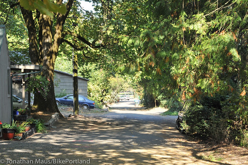
people at the entrance to SW Miles Place.
(Photo © J. Maus/BikePortland)
Tomorrow night, Multnomah County will hold a public meeting to discuss the future SW Miles Place Regional Trail. As part of the Sellwood Bridge Project, the County has decided to connect the path on the west end of the bridge to the existing Willamette Greenway Trail from the Macadam Bay houseboat community just north of the bridge, to Willamette Park.
Currently, SW Miles Place is a quaint, quiet, potholed and under-developed street that consists of a few dozen single-family homes nestled between Highway 43 and the Willamette River. Back in June, residents successfully stopped the County from routing auto traffic from the houseboat community down the street. Now the big question is: How should the County re-design the road for the increased bicycle traffic expected once the bridge opens?
Miles Place resident Roger Robinson said he and his neighbors are worried that their quiet street might turn into a thoroughfare for bike “commuters”. Robinson sees “commuters” as distinctly different than “pleasure bikers”. He’s worried that if Miles Place gets repaved and has sidewalks and sharrows added to it, people on bikes would zoom through too fast.

Instead of encouraging all bike traffic to use Miles Place, Robinson says he and a group of residents will urge the County to also build a bike path on the Willamette Shoreline Trolley right-of-way. “We’re going to push for that,” Robinson told me on the phone today. Robinson would like to see the County provide separate paths for “pleasure bikers” and more A-to-B minded bike commuters.
“The neighborhood would like the commuters to slow down just like the pleasure bikers do, as speeding through such a small neighborhood can be extremely dangerous.”
If the County does route all bike traffic through Miles Place, Robinson said they’ll ask that everyone obeys the 5 mph speed limit the neighborhood urges all auto users to observe. “Everybody in our neighborhood is concerned about safety,” he says, “… at times commuter bikes try to come through the neighborhood with no respect for the slow speeds necessary to navigate the neighborhood safely. We want to insure that any increase in commuter traffic must slow down to the 5mph that all cars now observe.”
So far, exactly how Miles Place is redesigned is up in the air. Will it get minor repaving to smooth out a few rough spots? Or will it get a full re-do, with new sidewalks, lighting, paving, stormwater collection features, and so on? If a significant redesign happens, will residents maintain the existing on-street parking they enjoy? Will trees have to be removed? Should different modes be separated or would a more mixed environment (like a “woonerf“) be more appropriate?
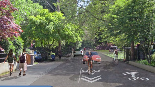
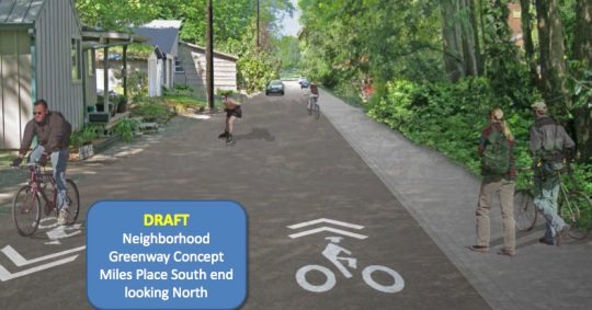
Here’s Miles Place today, looking south:

And here’s a draft mock-up from the County showing what new features would look like:
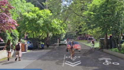
And here’s Miles Place today, looking north:
And the draft mock-up:
Not mentioned much officially (at least so far), is Robinson’s idea of pushing for the Willamette Shoreline Trail. That project was once considered by Metro as part of the Lake Oswego Streetcar project. Ultimately Metro “punted” on the project due to cost and right-of-way acquisition concerns (read more at PortlandTransport.com). Is now the time to resurrect that idea and push it forward?
Come to tomorrow’s meeting to learn more about this project and share your input.
-
SW Miles Place Regional Trail Public Meeting
October 17th from 5:30 to 8:00 pm
Easter Seals Building (5757 SW Macadam Ave)
More info contact Mike Pullen at mike.j.pullen@multco.us