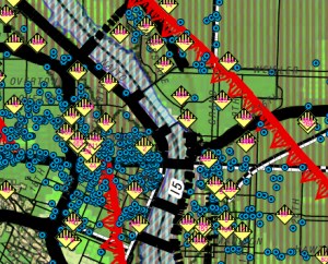


Blue dots are unreinforced masonry structures,
yellow diamonds are HAZMAT locations,
red line is a major fault.
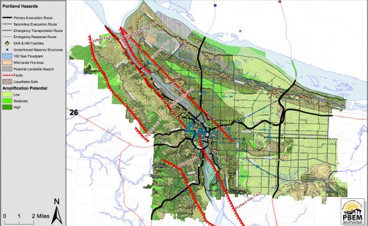
The Portland Bureau of Emergency Management (PBEM) has released a series of maps showing where natural hazards exist in each neighborhood throughout the city. In the interest of being prepared if and when disaster strikes (having a cargo bike all ready to go will only get you so far), I thought it’d be fun to see how these known hazards line up with popular bike routes.
Here’s more about the maps from PBEM:
“The maps identify natural hazards throughout the city. They offer a neighborhood coalition by neighborhood coalition account of known earthquake faults, flood plains and other dangers, including hazardous material sites, steep slopes and forested areas at risk of fire. The maps also show community resources – such as evacuation routes and key transportation corridors used during emergencies, hospitals, county clinics, schools, fire stations and police facilities – within each neighborhood coalition area.”
I had no idea about the East Bank Fault that stretches from inner southeast all the way north. And wow, all those unreinforced masonry structures downtown. When the big one hits, I hope I’m working from home. Speaking of which, I live very close to the “Primary Evacuation Route” of I-5; but I have to say I can’t imagine that working out too well. I mean, I-5 can’t even handle rush-hour traffic on a normal weekday, so I don’t exactly see myself jumping in the mini-van and making a quick getaway when the shaking stops. Another thing that stood out for me are all the HAZMAT locations scattered around the city. Eeek.
How about you? Are the places you ride going to be underwater, up in flames, oozing toxic chemicals, or buried in rubble when disaster strikes?
And if you’re into preparedness and cargo bikes, put the Disaster Relief Trials on your calendar for June 17th!
You can download the full citywide map, or a map specific to your neighborhood coalition from the Hazard Maps page on PBEM’s website