
Back in 2006, Metro-area voters approved a natural area bond measure which identified the Tonquin Regional Trail (a series of routes connecting Tigard, Tualatin, Sherwood, and Wilsonville) as a priority for development.
Planning kicked off in 2009 and recently the Project Steering Committee announced the recommended alignment for the trail system.
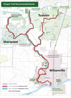
Their recommendation creates connections (at the north end of the the trail system) with the Westside Trail, Fanno Creek Trail, and Tualatin River National Wildlife Refuge. Winding south from those points the Tonquin Trail continues through Sherwood and Wilsonville, ending near Champoeg State Park.
Committee members and project staff are clear that the Tonquin Regional Trail is designed for more than recreation.
In an announcement of the committee’s recommendation, Metro says that the trail will provide “new ways for people to travel to work, shopping, schools, nature and more.”
This trail system has been in the works for a long time and is regarded as an essential component of making biking and walking more feasible modes of transportation in the southwest Metro region. In 2005 the Bicycle Transportation Alliance named the Tonquin Trail the 5th highest priority project, outranking both the Fanno Creek Trail and Safe Routes to Schools.
Some sections of the trail are already in place and others are on the cusp of construction. One section through Sherwood recently received federal funding.
You can hear more about the Tonquin Trail master plan for yourself at the Wilsonville Transportation System Plan update meeting on January 11th at 5:30pm at Wilsonville City Hall.
Complete information on the plan, including upcoming meetings and a list trail sections which are already built, is on Metro’s Tonquin Trail website.