

On Friday, October 14th you can get a sneak peek at TriMet’s Portland Regional Trip Planner, which they bill as the “first open-source, multi-modal trip planner produced by a U.S. transit agency.”
Over three years in the making, TriMet’s new tool will function similarly to how you get trip directions on Google Maps; but unlike Google Maps, TriMet’s trip planner will let you plan trips that combine transit, walking and biking into a single itinerary. Making it even more attractive is the fact that it uses all open source technology through a partnership with OpenPlans.
When Michael Andersen checked in on this project
for us back in July 2010, he called it the “holy grail” and wrote, “Suffice it to say, Portland’s transportation geeks are very excited.”
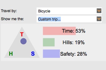
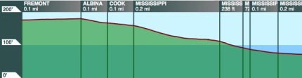
Beyond being multi-modal and open-source, the tool has other nifty features. One of them is a way to filter bike trip results based on how you prioritize of time, hills, or safety (see graphic above). The new trip planner will also provide you with an elevation chart.
You can play around with the beta version of the tool on TriMet’s website. The Portland Regional Trip Planner was funded through a Metro Regional Travel Options grant.
The public sneak peek at the new Regional Trip Planner is Friday, October 14th from 10:30 to 11:30 am in Metro Council Chambers (600 NE Grand). The official public launch will follow on Saturday.