

Bike touring, camping, and long distance rides have become increasingly popular in the Portland region. More people than ever are heading out of town for a few days by bike, challenging themselves with 100+ mile rides, and using our light rail system to do quick overnighters in the local mountains and other natural areas.
information for bike riders.
Now, PBOT has made your bike exploration possibilities even more do-able thanks to veteran superstar map guru Jeff Smith. Jeff has just completed a series of 11 new recreational cycling maps that help take a lot of the mystery about which roads and routes are best.
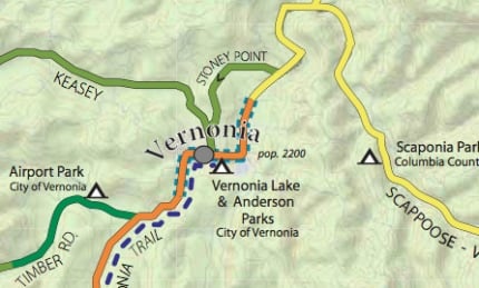
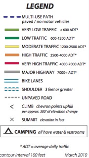
The new maps are available online for free via PDFs you can download and print. The routes surround the Portland metro area, from just north of Salem up to Clatskanie, and from the Coast Range to the Cascades. The new maps are extremely useful because they include information such as traffic volumes, whether or not hey have shoulders and/or bike lanes, elevation changes and hills, camping sites, and various points of interest.
Here’s a list of the new maps, with links to PDFs:
Map 1 – Vernonia Clatskanie
Map 2 – Rainier St Helens
Map 3 – Banks Scappoose
Map 4 – Forest Grove West
Map 5 – Yamhill McMinnville
Map 6 – Hillsboro Sherwood
Map 7 – McMinnville Salem
Map 8 – Woodburn St Paul
Map 9 – Mollala Silverton
Map 10 – Estacada
Map 11 – Sandy Troutdale
Start planning your adventures! More info on PBOT’s website.
— In other mapping news today, the Portland Tribune has a great article about the history of Metro’s Bike There map and Jeff Smith himself is co-presenting with Metro’s Matthew Hampton about maps at a brown bag discussion at the City of Portland building.