“Since the Vancouver Ave bridge has been out I have been unable to find a safe route to work.”
— Brian Tang in a posting to SeeClickFix
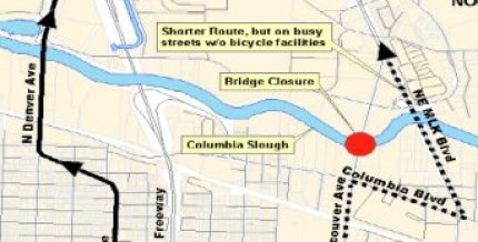
A construction project that has completely closed the Vancouver Avenue bridge over the Columbia Slough in North Portland is causing headaches and is highlighting the poor north/south biking options in the surrounding area.
As I reported back in April, the project began in May and the bridge closure is expected to last through the end of December. In the comments to that story several people expressed concerns about the poor bikeway quality on the proposed detours* and there were questions about why PBOT would do this project during the summer months.
To give you an idea of the problem, here’s an issue posted too SeeClickFix 12 days ago by Brian Tang (emphasis mine):
“I commute from Vancouver to east Portland by bicycle. Since the Vancouver Ave bridge has been out I have been unable to find a safe route to work…. now that the bridge is completely out, I am forced to try to bicycle across the Columbia Slough on MLK (HWY 99E), which is three lanes in each direction with no shoulder and no sidewalk and cars traveling at 55 mph. When I tried following the auto detour on Columbia Boulevard, I hit a storm drain that was about 2 inches lower than the roadway and almost went down right in front of the right front tire of a big rig that was passing by at that moment. How am I supposed to get to work without risking my life? I don’t have a car or even a license and the number 8 bus only goes halfway across the industrial area.
Please close a lane on MLK and use Jersey barriers to create a bicycle and pedestrian construction detour.”
And earlier this month, Gary Kercheck wrote in to tell us he has been taking the MLK/Columbia detour southbound and “will echo the laments of pretty much every other bike commuter here. It’s not at all ideal and the city has really dropped the ball on this.”
Another commenter, Eric Smith, wrote, “The city needs to make that Interstate route suck much less. Or is there any way to carve out a decent lane along MLK until you can cut down to Schmeer?”

Unfortunately, PBOT does not have jurisdiction over MLK. Because it’s a state highway, any changes must go through ODOT.
I talked to PBOT Capital Projects Manager Paul Gornick about these issues this morning. He said he’ll set up another meeting with PBOT bike coordinator Roger Geller and he’ll consider taking another trip to the work site and observe the detours to see what, if anything, can be done to improve them.
As of right now, Gornick confirmed that PBOT has not added any additional signage to warn road users of increased bike traffic to either of the two proposed north/south detours.
As for the scheduling, Gornick says they have no choice but to do the project now because of the “in-water work window” specified by the U.S. Department of Fish and Wildlife. Because the bridge goes over a natural area (the slough), certain aspects of the project can only occur between June 15th and September 15th. (This ‘in-water work window’ affects many projects in our region.)
I expect to hear back from Gornick in a few days and will keep you posted on any developments. In the meantime, I would love to hear feedback from people who have been impacted by this closure and who have tried the proposed detours.
*The other proposed detour, Bryant/Interstate/Denver, is not only out of the way, but the bikeway on Denver north of Columbia leaves a lot to be desired as well.