coming to the Morrison Bridge.
(Photos © J. Maus)
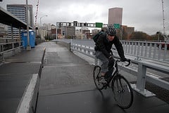
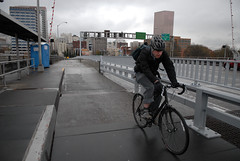
On March 30th, Multnomah County finally cut the ribbon on a new pathway for biking and walking across the Morrison Bridge that was 12 years in the making. Unfortunately, when I rode it on opening day it left quite a lot to be desired; and it turns out I wasn’t the only one who felt that way.
The day the bridge opened, former transportation planner and policy analyst at Metro, Daniel Lerch, fired off an email to the county with detailed explanations of several aspects of the bridge’s design he felt were not safe. Here’s a snip from that email:
“While I was glad to see the well-designed safety barrier and some other excellent features, I was at first concerned and later disturbed at finding no less than five design issues that, in my opinion, pose serious safety hazards to novice and less-than-fully-alert cyclists.”
be installed near Water Ave.
In addition to those design issues, Lerch said he felt some of the signage and markings felt like they were designed by “road and highway engineers used to thinking about how to direct cars, and not by bicycle specialists who the specific safety needs of cyclists.”
After hearing from Mr. Lerch, the Bicycle Transportation Alliance, and others, Multnomah County met with City of Portland staff to discuss the issues and they have released a list of changes they plan to implement. I’ve posted that list below in its entirety:
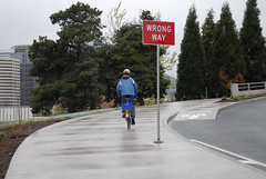
Location: Alder Street ramp
Movement: Westbound wrong-way bicycle traffic
Concern: Some might assume that the concrete sidewalk continues on a level surface onto the asphalt and will continue straight, especially if the crosswalk sign is on.
Solution: Railings are currently being installed to prevent bicyclists from traveling straight through crosswalk.Location: Bridge Deck
Movement: East/westbound bicycle and pedestrian traffic
Concern: Potential for bike/ped conflicts
Solution: County staff and Bicycle and Pedestrian CAC members will be monitoring usage of the path in late May/early June. Monitoring strategy to be determined at May 12th CAC meeting.Location: Naito Parkway
Movement: Southbound and northbound bikes/peds
Concern: Lack of directional signage makes path entrance hard to find
Solution: Additional way finding signage will be installed by the City of Portland.Location: Naito ramp
Movement: Westbound bicycle traffic
Concern: Visual separation hard to distinguish between path and on-ramp
Solution: The County will install reflective tape/striping to distinguish edge of path from ramp.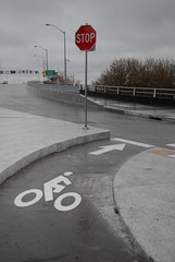 The Alder St. ramp as
it crosses Naito.Location: Alder Street ramp crossing
Movement: Eastbound vehicle traffic
Concern: Eastbound motor-vehicle traffic on entering the bridge via the Naito ramp must be better prepared for crossing bikes and pedestrians.
Solution: The City will mount temporary orange flags to the two (2) bike/ped crossing sign to better draw attention.Location: Alder Street ramp crossing
Movement: Downhill bicycle traffic
Concern: Bicycles traveling at a high-rate of speed
Solution: The County will provide a “Look->” marking similar to those found on Hawthorne Bridge. We also recommend using a shark’s teeth yield line marking at either end of the potential conflict zone area. These markings would inform bicyclists where they are required to yield if a pedestrian or bicyclist is entering on to the path at the Alder crossing.Location: Water Ave ramp
Movement: Eastbound bicycle traffic
Concern: Visual separation hard to distinguish between path and on-ramp
Solution: The County will install reflective tape/striping to distinguish edge of path from ramp..Location: Water Ave ramp start / terminus
Movement: All
Concern: Lack of directional signage makes path entrance hard to find. Potholes, I-5 traffic exasperate situation.
Solution: Additional way finding signage will be installed by the City of Portland. Improvement of pavement conditions by the City will be completed once funding becomes available.Location: Spiral Ramp from Path to Eastbank Esplanade
Concern: Potential conflicts where bicyclists and pedestrians using the spiral ramp merge with sidewalk users on the bridge path and Esplanade.
Solution: Install yield signs at either end of the spiral ramp.
Mike Pullen from the Multnomah County Public Affairs Office says the County will also work to monitor traffic on the new path in the coming months and the results of those counts will be used to “determine whether additional measures should be implemented.” At this time, Pullen says they’re still working out the implementation schedule.