(Photos © J. Maus)
[Publisher’s note: This article was written by contributor Daniel Ronan. He’s a student representative on the Oregon Bicycle and Pedestrian Advisory Committee and covers statewide programs and issues. Read his previous articles here.]
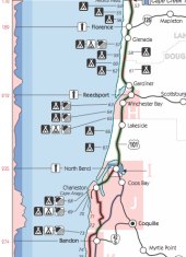
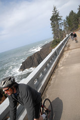
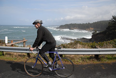
Each year, between 4,000 and 6,000 bicyclists take the Highway 101 route along the Oregon Coast, mostly during the warm summer months. What helps many on their journey is ODOT’s Oregon Coast Bike Map (PDF link) that details the 370 mile route and lists information on traffic volume, weather, elevation, state parks, and other helpful tips.

Last week, Sheila Lyons, the state’s Pedestrian and Bicycle Program Manager, came to the University of Oregon InfoGraphics lab (a part of the Department of Geography) to discuss cartographic design options for the reprinting of the Coast map, which is scheduled to happen next year.
“The Oregon Coast Bike Map is by far ODOT’s most popular bike map, people love this map,” says Lyons.
The meeting with some of the project coordinators, including Ken Kato, Ben Metcalf and Matt Landers, focused on updating the map to better alert riders to the suggested 101 Coast route. Central to the conversation was the question of how to include traffic volume, elevation, and shoulder width statistics in a more effective and easy to read format. Lyons addressed the trade-offs of giving too much information, “We want to give them information, but what we don’t want is a person looking at this map to say, ‘it’s too dangerous.’”
During the discussion, project coordinators held up Metro’s recently debuted Bike There! map as an example of how to use attractive, but appropriate symbology. Project coordinator Ken Kato said, “We’re looking to create a coastal experience,” which brought several head nods around the table.
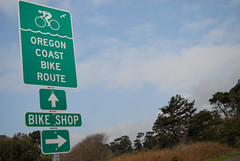
But that experience remains lacking in certain places along the route where signage is sparse and riders have a hard time avoiding high-traffic roads.
Lyons says many cities have suffered layoffs and budget cuts meaning that there hasn’t been enough money to fund bicycle improvements. But, even with significant funding challenges, there have been success stories. In Newport for example, supportive businesses (like Bike Newport), bicycle coalitions and neighborhood associations helped raise funds for new signage to divert bicycle traffic from a congested section of 101.
In general, however, signage is relatively low in the project queue. Planning around choke points with necessary improvements remains the largest obstacle. In Newport for example, while local advocates have made progress with signage, the biggest problem is the lack of safe bikeways on the bridge to the south over Yaquina Bay.
While funding for the state’s bicycle network remains a challenge, a bright spot for the Coast Route, says Lyons, is the possible connection with other networks on the horizon like the Oregon Scenic Bikeways and the U.S. Bicycle Route System.
But even on its own and with its shortcomings, the Coast Route remains a popular attraction for bike tourists from Oregon and across the globe.
If you’ve ridden the Coast Route (especially if you used ODOT’s map), what was your experience like? ODOT and the folks at the UO Department of Geography are interested in your feedback. Be sure to leave your comments and suggestions below so we can all have a better “coastal experience.”
— You can find the Oregon Coast Bike Map online (as a PDF), in various visitor centers and bike shops, or by calling the ODOT maps hotline at (503) 986-3556.