
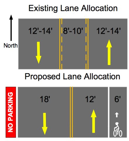
this one, although it’s not finalized)
on downhill side of N. Mississippi Ave.
is among several bikeway
improvements planned.
(Graphics: PBOT)
The City of Portland’s Bureau of Transportation is set to install new signage, pavement markings and a new travel lane for bicycles on N. Mississippi Avenue.
It’s been over a year since Bureau of Transportation staffers painted temporary bike lane symbols on the uphill portion of N. Mississippi Avenue from N. Graham to Cook streets.
Their plan was to put that stretch of road on a diet, removing the existing center turn lane to make a new 6-7 foot wide traffic lane for bicycles in the uphill direction.
But when months passed and the temporary symbols wore off, it was clear that the project had hit a snag. Back in April of this year, we inquired about the project and PBOT staffers said that their Maintenance Operations Group — which has a truck and equipment yard adjacent to the project area — objected to the plans.
PBOT’s Jeff Smith has been managing the project. He told us in April that, “When they [maintenance staff] saw it laid out there, they were concerned about the safety of downhill cyclists.”
The hill is a key north/south connector for folks who don’t like the high-speed motor vehicle traffic and narrow bike lane on N. Interstate Avenue and for whom N. Williams is too far out of the way. PBOT estimates that 350 people bike on the hill each day.
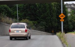
veers downhill and to the right.
Since April, Smith and PBOT engineers have been meeting with managers at the maintenance yard to try and hammer out a solution that addresses the needs for bikeway improvements while also alleviating their concerns.
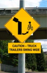
Primary among their concerns was a blind corner (see photo at right) on the downhill section that is also where trucks slow down and stop to turn left into the yard. They felt that people on bikes ride so fast down the hill (PBOT studied the speeds and found that 85% of bikes went 24.4 mph, about the same as cars) that they might run into the back of trucks waiting to turn left (remember, the center turn lane would no longer be there).

in the downhill direction, just
prior to a sharp and somewhat
blind right-hand turn.
They were also worried that with PBOT’s proposed lane configuration (see it above), someone on a bike might try to squeeze by on the right of a stopped truck, and could be hit when the truck swings wide to enter the driveway.
Along with those practical concerns, there is no doubt that the fatal bike/truck crash two years ago at the nearby Greeley and Interstate intersection still looms large in the minds of both drivers and managers at the facility.
Even with those concerns, PBOT engineers and bikeway planners have come up with a solution that all parties have agreed on.
Along with the new lane configuration, a warning sign and a pavement marking will be placed prior to the blind corner in the downhill direction.
PBOT expects the project to be completed by the end of August.