
(Photos © J. Maus)
If you’ve ever tried to navigate across the I-5 bridge from Portland to Vancouver (or vice versa) you know that it’s not for the faint of heart.
With a disorienting combination of sidewalks, a freeway on-ramp and off-ramp, and several high-speed streets that access hotels and the Janzten Beach shopping center, it seems like it was designed and planned before bicycles even existed (or clearly before they were considered a viable means of transport).
Thankfully, conditions are likely to improve soon thanks to a collaborative effort by the City of Portland, the City of Vancouver, and the Oregon Department of Transportation (ODOT).
|

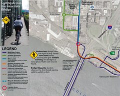
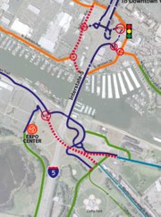
Sneak peeks at new I-5 crossing bike map.
|
Jennifer Campos, a transportation planner with the City of Vancouver, says that over the last few years, she’s noticed an increase in requests for information on how to bike across the bridge and get through the Jantzen Beach and Delta Park areas. PDOT bike map guru Jeff Smith also noticed a demand for an I-5 crossing route information and he took the initiative to create a map — but it has only been available online.
Now Campos says, Vancouver has received a federal grant to improve bicycling conditions and they will use the money on a variety of projects including a new map and improvements for bike access on both sides of the bridge.
For starters, Campos says she’ll use the grant to re-design and print a new map titled, Cycling Across the Interstate Bridge and they’ve hired Portland-based Alta Planning to complete the project. The map is due out soon but you can see a few sneak peeks in the photos above (stay tuned for an update once it’s done).

up on your way to and from Vancouver.
On the west side of the bridge, Campos says they plan to widen the bike path, install an informational kiosk, stripe a dedicated bike turn lane on Columbia and add directional signage. On the east side of the span, plans are in place to fill potholes, stripe the parking lot area with sharrows “to delineate bicycle movement”, and add bike-specific signage (which is part of a citywide bicycle route signage program they will implement next year).
Campos adds that ODOT has committed to making infrastructure improvements on the Jantzen Beach side of the bridge.
For their part, the City of Portland plans to extend their bicycle route signs up into Delta Park and Jantzen Beach.
Campos says Vancouver will spend about $8,000 on designing and printing the map and doing these minor improvements near the bridge. That money is part of a $353,000 grant from the federal Congestion Mitigation and Air Quality Improvement Program that will cover several other bicycle improvements in Vancouver including the citywide bicycle route signage program, new bike parking downtown, striping of bike lanes, and education and encouragement programs.