
This article was written by North Portland resident and member of the Smarter Bridge coalition, Matthew Denton. Mr. Denton shares his evaluation of the bicycle and pedestrian facilities that are being proposed as part of the $4.2 billion Columbia River Crossing project. It was first published on SmarterBridge.org and some edits have been made for clarity and readability.
What is being proposed?
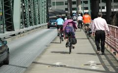
The current proposal being advocated for the Columbia River Crossing (CRC) combines bicycle, pedestrian, and light rail on a single structure separate from the main highway bridge. The bicycle/pedestrian facility consists of a roughly 1.5 mile long, 14-16 foot wide path for both directions of travel, with bicycles and pedestrians mixed.
The bike and ped path would be accessible from a ramp near the Expo Center, a ramp in downtown Vancouver, (roughly a quarter mile north of the shore) and according to the plans, an elevator connection to Hayden Island, (shared with the transit station.) It would be very similar to the I-205 bridge pathway, in that one would have to climb a fairly long but not particularly steep hill in the act of crossing the bridge. Unlike on the I-205 bridge, one would not be riding between the two freeway sections, but instead next to a MAX trackway (probably separated by a fence, although current renderings don’t show that).
It will remind most people of a cattle chute much like the I-205 path. MAX trains would be running at 50+ mph, but at intervals, somewhat different from the continuous auto and truck traffic on I-205.
How is this better than what what we have now?
Crossing the Hayden Island interchange would no longer be an impediment, which is a major improvement, but the approaches at either end would be similar to what they are now: Vancouver’s would be quite good, connecting to Washington St. around 5th, although one will have to backtrack to get to the Vancouver waterfront.
The Portland MLK/Vancouver/Williams/West Marine Drive approach route would still involve a fair amount of out-of-directional travel to get to the ramp that then takes you up to the bridge level. While there are certainly aspects of that that are less than perfect, the proposed bicycle path is a major improvement over the current bicycle crossing. After all, the pathways on the existing bridge are only 4 feet wide.
“And that is the problem: The proposed bridge does help bicyclists while they are crossing the river, but the traffic from the freeway lanes will discourage bicycle usage in north Portland by clogging up the bicycle routes with cars and trucks.”
How is this worse than what we have now?
What isn’t mentioned anywhere in the Columbia River Crossing analysis is what the automobile traffic would be like on the other streets in the Portland area if this bridge is built.
For the morning rush hour, starting from the Vancouver side, most of the traffic would be on the freeways in Washington state, so a bicyclist wouldn’t encounter significantly more traffic than now. But since the bridge is 12 lanes (6 lanes in each direction) and 65% of the traffic that crosses the bridge southbound is heading to points south of Columbia Blvd, that means that there would be 4 lanes of traffic trying to go south on I-5 through North Portland.
I-5 is only 3 lanes there, so a full lane (2000 cars/hour or 1 car every 3 seconds) would have to get off the freeway and try to make their way south on the through streets like Vancouver, Interstate, Denver, and Greeley. Add in the vehicles that currently get on I-5 going south at rush hour (for instance, the semi-trucks that get on at the Columbia Blvd ramp) to that mix, and the result would be that using the bicycle lanes on Vancouver, Interstate, Denver, or Greeley at rush hour would be very similar to using the bicycle lane on SW Broadway: a lot of motor vehicle traffic, much of it in a hurry and trying to find a faster way through.

(Download complete presentation here (6.7MB PDF))
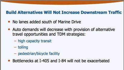
The official traffic estimates say that in 2030, slightly less traffic will go over the 12-lane bridge each day (assuming it has tolls and an adjacent transitway) than would cross the existing 6 lanes under the “no build” option (which assumes no transit, no tolling, no carbon taxes and gas prices back at 2006 levels). However, most of that traffic will be at rush hour. With the 12 lane bridge, for 5.5 hours a day, all 6 of the lanes in one direction or the other will be full, and they will then overflow onto the bicycle routes south of the bridge. With the current 6 lane bridge, 3 of the lanes in one direction or another will be full for 15 hours a day in 2030, (assuming the above,) but all that traffic will fit on I-5 though North Portland, and therefore will not spill onto the bicycle routes.
And that is the problem: The proposed bridge does help bicyclists while they are crossing the river, but the traffic from the freeway lanes will discourage bicycle usage in north Portland by clogging up the bicycle routes with cars and trucks.
How could smarter bridge alternatives provide better facilities?
the Hawthorne bridge is often congested.
(Photo © J. Maus)
First of all, the proposed bi-directional, 14-16 foot wide section is not wide enough for a “world class” bicycle path.
For comparison, the smallest widths being proposed for the Sellwood Bridge replacement are 10 feet for each direction (20 feet total), although some are even wider and have separate lanes for bikes and pedestrians. Also keep in mind that the Hawthorne bridge bike path is 11 feet in each direction (22 feet total) and sees congestion at rush hour.
A smaller, smarter bridge that carries less traffic will reduce the off-bridge impacts described above. However, the bicycle facilities themselves could be far superior to what is being offered on the mega-bridge. The sheer length, the lack of easy connection to either river bank, and the lack of easy connection to Hayden Island are all caused by the scale and height of the proposed replacement bridge.
“A 12-lane freeway with a bicycle path has the same sort of ideological issues as putting a bike rack on a Hummer.”
Crossing this bridge would still be a good 1.25 mile ride, because the river is still fairly wide. Smaller scale alternatives would offer connections to the south and north Columbia riverfronts, as well as a ride (instead of an elevator) to Hayden island.
One smarter alternative moves the main shipping channel south, by fixing the railroad bridge, and retaining the current bridges for I-5. This means that a shorter, cheaper transit bridge can follow the profile of the current bridges, with a lift span still available for those very rare occasions (restricted to night time) when an oversized piece of equipment must be moved. This reduces the size of the hill in the middle of the bridge significantly.
Optionally, one or more non-freeway motor vehicle lanes could be attached to the transit-pedestrian-bicycle bridge. This would reduce the isolation that cyclists would experience in the Columbia River Crossing proposal, a cause of concern to some cyclists during late hours.
What are the ethics here?
Most people ride bicycles (besides the fact that riding a bicycle is fun) because they care about the environment: global warming; the amount of our landscape taken up by parking; peak oil; the obesity problems our population faces; and any number of other serious problems that bicycling helps.
As such, a 12 lane freeway with a bicycle path has the same sort of ideological issues as putting a bike rack on a Hummer. It is certainly better than a Hummer without a bike rack, but that doesn’t make it a good idea. Those 12 lanes of freeway add $3 billion to the cost of this project over the the smarter alternatives.
__________
Sources (from ColumbiaRiverCrossing.org):
- CRC Project Powerpoint Presentation to the Portland Planning Commission (presented March 11, 2008: 6.7 MB, PDF)
- Map/graphics: Downstream Replacement Bridge with bus rapid transit or light rail (3 MB, PDF)
- CRC Draft Concepts (7.8 MB, PDF)
- CRC Pedestrian and Bicycle Fact Sheet (512 kb, PDF)
- Pedestrian and Bicycle Advisory Committee Working Documents (1.8 MB, PDF)
For more information on the CRC project visit ColumbiaRiverCrossing.org, SmarterBridge.org, or browse my previous coverage.
You can also attend the BTA’s “members-only” forum on the CRC tomorrow. Details here.