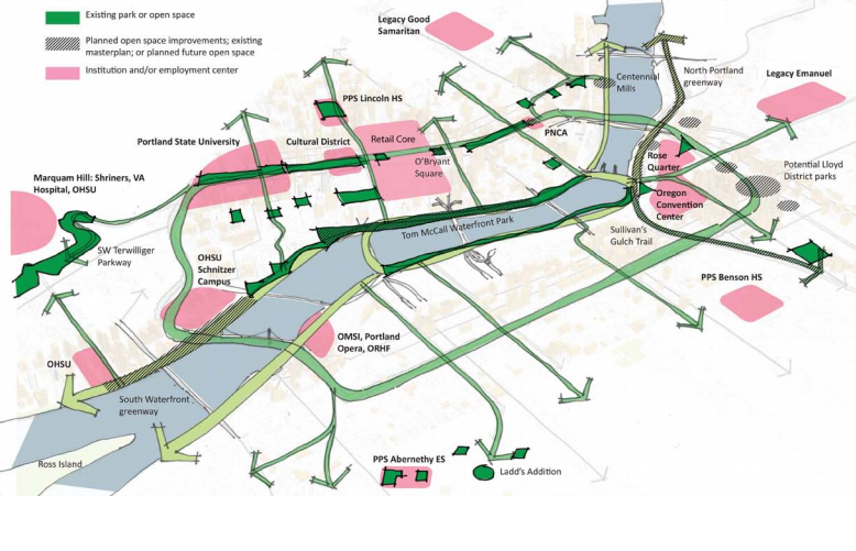
(Image: Portland Bureau of Planning and Sustainability)
City planners and stakeholders are looking closely at an unsolved problem of Portland’s central eastside: the route for a continuous north-south bikeway somewhere inland from the Eastbank Esplanade.
The leading options are, at this point, numerous and intriguing: Grand, 6th, 7th and 9th.
Planners are also looking, in closer detail than ever, at the possible options for a new biking-walking bridge over Interstate 84.
If a route can be built, it’d form the eastern rim of a vision the city started pursing in 2012: a “Green Loop” linking Portland’s downtown and central eastside, from the Broadway Bridge to the new Tilikum Crossing.
The catch is that all four options being discussed for the Green Loop through the central eastside would require removing more than 100 auto parking spaces.
Options for a new biking-walking bridge across the freeway

Let’s start with the bridge.
As we wrote last week, the potential for a bridge across the freeway is rising thanks to the huge housing projects being proposed in the Lloyd District by American Assets Trust.
Development fees from more than 1,000 new apartments in the development pipeline could go a long way toward paying for this long-discussed bridge that would for the first time connect the street grid across Sullivan’s Gulch.
Until last week, in fact, the city’s transportation bureau had allocated $300,000 in possible revenue from a new transportation income tax to planning the bridge. (That line item disappeared last week and was replaced by planning for protected bike lanes in outer east and southwest Portland.)
Anyone who’s tried to cross I-84 on a bike between 28th Avenue and the Willamette River knows how much difference a car-free connection here would make. And anyone who’s walked on the Eastbank Esplanade would probably appreciate the chance to move north-south bike traffic off that route.
Based on the image above, the lowest-cost option would seem to be a diagonal bridge connecting NE 7th Avenue to SE 8th Avenue.
Four possible routes for an all-ages bikeway south of I-84

This raises the second question: south of I-84, what route would create the best connection to SE Stephens Street and Tilikum Crossing?
And what would the route look like?
Page 32 of the notes from last week’s meeting of the Southeast Quadrant Stakeholder Advisory Committee starts to answer these questions.
Above are two maps of the four options the city has been considering: Grand, 6th, 7th, and 9th. (North of Sandy, part of 8th Avenue might also be used in a couplet with 7th.)
And below are two possible cross-sections for the routes. First, here are before/after shots for a bidirectional 12-foot protected bike lane on the 80-foot-wide 7th Avenue:
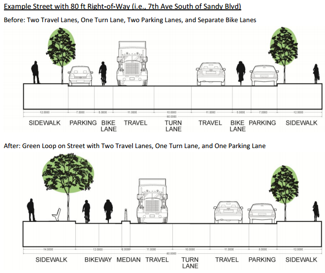
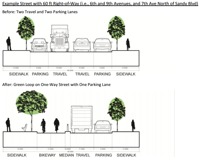
Second, here are before/after shots for the same bidirectional 12-foot protected bike lane on the 60-foot-wide 6th and 9th Avenues, plus 7th Avenue north of Sandy:
City staff didn’t prepare a cross-section for the Grand Avenue, though it was seriously discussed as a possible route at a June design charette. Grand, whose road bed is 56 feet from curb to curb, has by far the most commercial activity and freight traffic, but adding a 12-foot protected bike lane with a buffer would require removing both one lane of parking and one mixed-traffic travel lane.
The city prepared a handy chart for comparing the upsides and downsides of each route:

As you can see, 7th Avenue tops this list thanks to its width, open space opportunities (on vacant lots nearby) and relative directness.
Meanwhile, city staff recommended that Grand be removed from consideration, due mostly to the fact that it’s a major freight route and the city’s working plan is to keep trucks and bikes on different streets whenever possible.
Two options that weren’t discussed in this report:
- 8th Avenue. I assume this is because it’s interrupted by a parking lot between Belmont and Morrison.
- A neighborhood greenway design, with traffic diverters and speed bumps, rather than protected bike lanes.
Advertisement

Interested in more detail? Last week’s staff report has plenty. Here’s their summary of the conclusions they made about each possible route.
Option A: Grand Avenue
The option that best aligned with the concept of using the Green Loop to reinforce the mixed-use corridor was a 2-way cycletrack on Grand Ave. There were several issues with this concept. Both a travel lane and parking lane on one side of Grand would be lost to accommodate the new cycle track. This has significant traffic impacts, particularly at bridgeheads where traffic weaving and new signalization would be required to accommodate left turns. Approximately 100 parking spaces would be lost within the main retail corridor. Additionally, the traffic signal progression on a one-way street means that southbound bicyclists (traveling against the main flow of traffic) would frequently be stopped at signalized intersections.
Staff propose that this option be removed from further consideration. Although this option aims to achieve a more pedestrian and bicycle friendly Grand Avenue where there is the most potential for mixed use, it would have the largest impact on freight movement, the highest costs due to the infrastructure improvements necessary to make it work well, and provides relatively few benefits over other options.
Option B: 6th Avenue
This option is proposed by staff following multiple tours of potential north-south alignments. There are many design options for accommodating the Green Loop on 6th Ave, one of which would be similar to the 60 ft street section provided above. In general, this would require either the loss of one travel and one parking lane, resulting in a one-way street and the loss of approximately 125 on-street parking spaces, or the loss of both parking lanes or approximately 250 spaces.
Staff propose that this option continue to be analyzed over the next year. 6th Ave has many features of a unique place, with historic buildings, comfortable street width and scale, and a growing list of new development and building rehabilitation projects that show market interest. Its location exactly in the middle of the district makes access to all parts of the district easy. Mixed use zoning (EXd) lines the western side of the street. Stormwater improvements likely to be included as a part of the Green Loop would help to overcome known street flooding problems along much of 6th Ave.
Option C: 7th Avenue (With Potential 8th Ave Couplet North of Sandy Blvd)
This option was discussed during the Transportation Working Group meetings. This is the only option that includes a segment with 80 ft right-of-way width. While 7th Ave was identified as a secondary freight route by the TWG, it already has two bicycle lanes. As shown in the street section above, the Green Loop would result in the consolidation of these two lanes to one side of the road. For this portion, the loss of a single lane of parking would result in approximately 125 fewer parking spaces. As with 6th and 9th Avenues, north of Sandy Blvd, this alignment would be carried on 60 ft of right-of-way and would result in additional losses of parking or travel lanes similar to those options.
Staff propose that this option continue to be analyzed over the next year. 7th Ave provides an alternative to 6th Ave. Both are near to the same retail, commercial and residential areas, but where 6th Ave reduces auto access to create a more comfortable pedestrian and bicycle environment away from priority freight routes, 7th Ave consolidates and protects existing bicycle lanes on a large corridor with considerable freight activity.
Option D: 9th Avenue
This option was discussed during the Transportation Working Group meetings. Since 9th Ave has the same roadway width as 6th Ave, the same design options apply here. It is estimated that approximately 125 parking spaces would be lost if 9th Ave were converted to a one-way street, and approximately 250 parking spaces would be lost if both travel lanes remained (but neither parking lane did).
Staff propose that this option continue to be considered as a backup if other options are not supported or are determined to be unfeasible. The Bicycle Plan for 2030 designated both 7th and 9th Avenues as future bike boulevards and there is a proposed signal at 9th Ave and Sandy Blvd that would improve that crossing. This alignment also has the most direct access to neighboring areas to the south. Significant issues to address specific to this route include: (1) How the Green Loop can coexist adjacent to Franz Bakery and other major freight users, (2) How to connect to the proposed 8th Ave bridge over I-84 given the steep climb on NE Glisan St, and (3) Identification of potential amenities it could connect because it travels through the fewest mixed use areas and opportunities for open space.
Want to get involved? You can learn more about the city’s Southeast Quadrant plan here.
Thanks to reader Ian for the tip.