
(Image: Google Street View)
After our report last month about the Oregon Department of Transportation’s new “ORcycle” app for reporting biking problems, BikePortland reader Hazel G. decided to try it out.
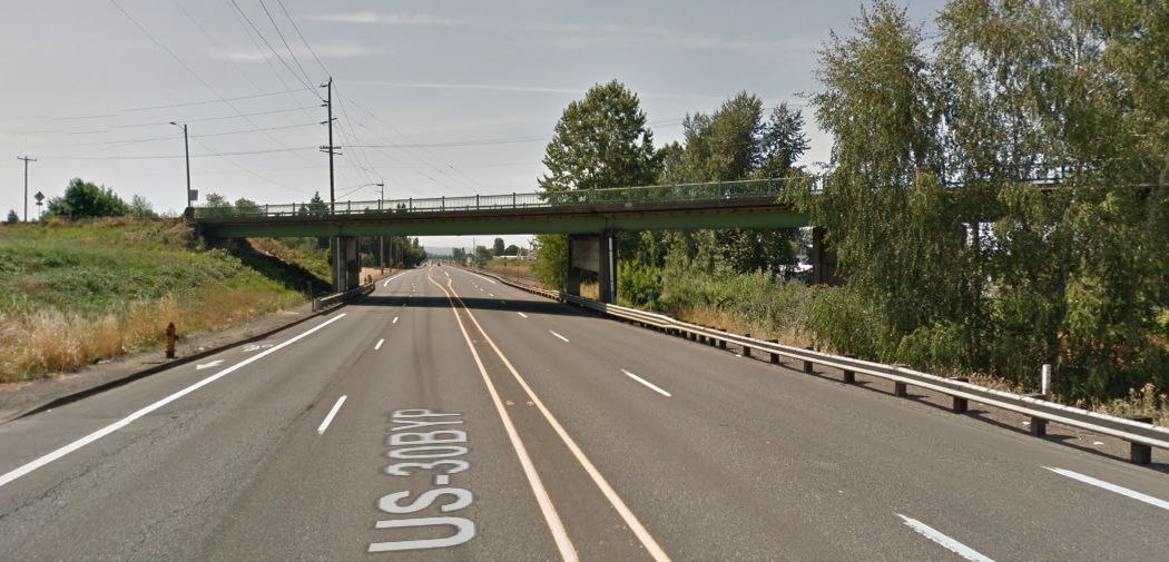
Hazel regularly bikes on NE Lombard Street, a U.S. highway managed by the state, under the overpass of 42nd Avenue. This is one of those overpasses where it suddenly becomes less important to separate people biking from 50 mph motor traffic than to ensure that both lanes of motor traffic don’t have to merge into a single lane. (This is a strange American approach to street design that we compared with European practices in 2013.)
“Super scary spot to ask bikes to mingle with cars and freight going 50+ mph,” Hazel G. said in an email. “The bike lane vanishes and there are signs warning that bikes are in the roadway. I pretty always just stop and wait until there is no traffic.”
So Hazel fired up her free ORcycle app to see what would happen if she told the state about this problem. A few weeks later, she got an initial email saying that her issue had been received and that she’d get a second email in a week or so after that. About week later, she got this email (emphases mine):
Thank you for bringing this bike lane gap to our attention. This section of Lombard was not previously coded as a gap in our bicycle facility inventory. I have asked our Asset Management Unit to correct this information so that this segment will be shown as a deficiency when we scope future projects in the area.
“There is not extra pavement width that could be reallocated to stripe bike lanes.”
— ODOTOn this segment of Lombard, the 42nd Ave Bridge creates a pinch point that results in the elimination of the shoulder/bike lane for approximately 350 feet westbound and 200 feet eastbound. Warning signs indicating the bike lane ends with a bikes “in roadway” rider sign are provided in both directions, per ODOT standards, to warn people driving and biking of the changing conditions. Unfortunately, the travel lanes and median have already been narrowed to fit under the bridge, so there is not extra pavement width that could be reallocated to stripe bike lanes. The location of the bridge supports and steep grade to the railroad tracks to the north also make widening the roadway to accommodate standard bike lanes very difficult and expensive, especially if constructed as a standalone project.
Most sidewalk and bike lane infill projects on ODOT highways are funded through the Sidewalks with Preservation (SWIP) program. We try to leverage SWIP funded improvements with other projects (e.g. repaving) in order to reduce design and construction costs, minimize construction impacts, and maximize what we can accomplish with limited funds. In conjunction with a future project, we may be able to construct curb ramps and pave a narrow path behind the guard rail and bridge supports to provide a separated route under the bridge for people biking. A pavement preservation project on Lombard (US30 Bypass) from MLK Blvd to 60th Ave was recently proposed for funding through the 2019-2021 State Transportation Improvement Program (STIP), but unfortunately was not selected for funding. It will likely be on the list for consideration again when we program the next round of STIP projects. I spoke with the City of Portland Bridge Unit, who owns and maintains the 42nd Ave structure, but they do not have any improvements planned to this structure in the coming years.
Thanks again for reporting this issue and please let me know if you have any additional questions.
Advertisement

Here’s Hazel’s summary of their further exchange:
I let her know that I was aware that there were bikes in roadway signs but asked if she would feel comfortable hoping that drivers would be courteous here since getting hit at 50+ mph would most certainly result in death. Her response was to alert me to better routes to take. Which I’m aware of but Lombard is the absolute fastest east west route in this part of town. I think this road is often ignored as one that even has a bike lane east of MLK. Getting this response also makes me want to ask why bother having a bike lane if you then acknowledge that part of it is incredibly unsafe?
Sorry for the rant. I’m amazed to have gotten a response at all but not really any solution. I’m also glad that I could bring this to their attention since it had managed to be overlooked in the past.
It’s nice to know that reporting on this app can have some small effect. But it’s also perfectly clear from this account that the other solution staring ODOT in the face — the possibility of forcing motor vehicle operators to merge with one another rather than with bicycle riders — is unthinkable to the agency.
According to the state’s online maps, Lombard carries between 20,000 to 30,000 motor vehicles a day on this stretch, almost all of which is probably through traffic. So a lot of travelers would be affected by a change, though it’d require traffic engineering to figure out if there’d actually be much delay.
But here’s the thing: in explaining to Hazel G. why the most efficient bike route through this area isn’t going to be made continuous, ODOT doesn’t consider the possibility of restriping to remove a passing lane. A convenient bike route through a city, connecting some of its bike-friendliest neighborhoods to some of its most important employment areas, is “extra” by definition. A lane that makes it easy to pass a truck in a car is not.
Prioritizing biking, apparently, isn’t even a possibility worth dismissing.
— Michael Andersen, (503) 333-7824 – michael@bikeportland.org