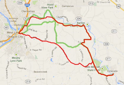
“Principal” proposed routes are in red and “alternative”
routes in green. See below for more maps.
A two-week virtual open house launched Monday to give people who bike and walk in Clackamas County a chance to share their expertise and opinions on the best routes for the county to improve.
It’s part of the county’s year-long Active Transportation Plan, an effort to improve healthy mobility, access, safety, and tourism in the county on the south side of the metro area.
For the new virtual open house, much of the focus is on a series of possible walking and biking routes that have been selected from many submitted earlier in the process.
For each of the routes, the county is asking:
1) Do you think this route should be the Principal Active Transportation (PAT) Route in this corridor?
2) Are there route alternatives that we’ve missed?
3) What other information about this route should we consider?
For example, here are some possible routes between Milwaukie and Oregon City, with the highest-scoring routes in red and the lower-scoring ones in green:
Some through what the county calls the “Industrial East”:
Two proposals between Oregon City and Lake Oswego:
A few through the Mount Hood area:
You can look at more of the specific maps here, and also take an online survey about transportation in Clackamas County here.
The online open house closes Sunday, Feb. 23. For more information, contact project manager Scott Hoelscher at 503-742-4524 or ScottHoe@co.clackamas.or.us.


