
(Photos © J. Maus/BikePortland)
Two days after a Metro engineer publicly called out the Oregon Department of Transportation for allegedly misrepresenting traffic data in a memo that sidelined a bike safety proposal for Southwest Barbur, another expert is adding new skepticism.
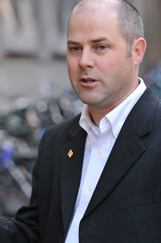
The latest critic is Chris Monsere, a Portland State University associate professor and nationally recognized expert in the effects of restriping roads to reduce auto travel lanes. In addition to questioning ODOT’s conclusions, Monsere questioned the agency’s priorities and said he was “disappointed in the way the analysis is framed.”
“Vehicle speeds are way too high on Barbur, safety is poor, and bicycle / ped accommodation is substandard,” Monsere writes. “Road diets have generally been shown to improve safety for all users. Motor vehicle delay at the peak hour shouldn’t be only decision variable.”
Barbur currently forces auto and bike traffic to merge into the same 45-mph travel lane as it crosses two narrow bridges. Neighborhood safety advocates have suggested removing one of two northbound travel lanes in order to have room for a continuous bike lane in each direction. ODOT has countered with a proposal to instead add flashing lights to a “bikes on bridge roadway” sign.
A traffic analysis earlier this year found that without further changes, a restriping would slow travel times in the morning rush hour and cause some traffic to divert onto Corbett, Terwilliger and other roads. ODOT said Thursday that these are the relevant findings from its examination of a road diet.
Monsere first shared his thoughts in a comment beneath our Thursday post. On Friday I contacted him directly to confirm the statements.
“I’d consider both analyses preliminary enough that 20 to 40 seconds of delay in the current condition is not significant to completely derail the road diet option,” Monsere added in an email. “A vehicle could easily be delayed 20 seconds by the new crosswalk beacon south of Hamilton that went in early this year (or for that matter the signal at Hamilton or Terwilliger).”
In his comment Thursday, Monsere also asked exactly which stretches of Barbur were analyzed for possible restriping. The lack of specificity on this in our previous coverage is in part my own fault — ODOT’s documents didn’t specify, and I didn’t ask. Here’s the answer, from Metro engineer Anthony Buczek.

“The road diet was proposed and therefore assumed from 1/4 mile north of the signal at SW 3rd/Miles to 1/4 mile south of the signal at Hamilton,” Buczek wrote Friday. Also, here’s a project description from Metro that offers a map of the road diet area (at right), which is actually divided into two segments.
The stretch doesn’t include any traffic signals, which Buczek has said are the significant chokepoints to road capacity on Barbur. This means that removing an auto travel lane on this stretch wouldn’t significantly reduce actual traffic capacity — it’d mostly mean that faster-moving northbound vehicles wouldn’t be able to pass slower ones during rush hour.
Monsere is director of PSU’s Intelligent Transportation Systems lab, co-chair of the national Transportation Research Board’s Safety Data, Analysis, and Evaluation committee, sits on the editorial board of the Journal of Transportation Safety and Security, and was a member of the TRB Task Force to develop the American Association of State Highway and Transportation Officials’ Highway Safety Manual.
Monsere concluded his comment Thursday night with a professional reflection.
“I can’t help but reflect on the assigned reading I give in class from the father of road safety analysis, Ezra Hauer,” Monsere said. “He wrote ‘Is it better to be dead than stuck in traffic?’ I think we know the answer to that question.”