
-Slideshow below/Day 2 Gallery–
(Photos © J. Maus)
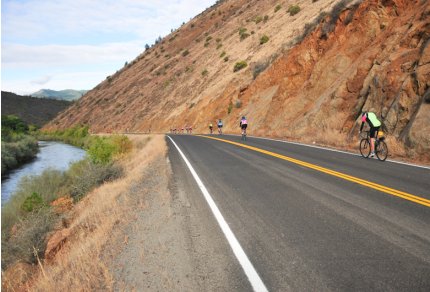
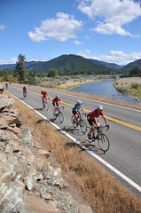
After yesterday’s tough haul into Yreka, today’s ride down the Klamath River Valley was just what the doctor ordered.
From Yreka we headed west on Highway 96, an officially designated Scenic Byway route that follows every curve of the Klamath River. Our 74 mile ride (see map and topo here) was mostly downhill, the weather was perfect, the road was smooth, and the countryside was fit for a postcard (or two).
|
|
Early in the ride, we pedaled over steep ravines connected by historic bridges dating from the late 1800s to early 1900s. In the upper valley, the land was dry and dominated by rocks, but as we rolled downriver, towering pines sprung up which eventually giving way to entire hillsides dotted with trees.
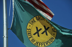
This is an isolated place, with people as determined and rugged as their river. It’s not hard to imagine why they wanted to break away from Oregon and California and create their own state. At our lunch spot at Klamath River School I saw my first official State of Jefferson flag, emblazoned with two X’s. According to locals, the X’s represent how they felt double-crossed by politicians in Salem and Sacramento.
[For more on the State of Jefferson, see the Wikipedia entry or the official website, StateOfJefferson.com.]
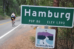
As we made our way to Happy Camp — an unincorporated community (pop. 1,100) on the ancestral homeland of the Karuk tribe and settled by gold miners in 1851 — we passed several tiny towns. One of them, Hamburg, has just 80 residents (three of whom were cheering us on as we passed).
In Seiad Valley, many riders stopped at the roadside store and post office. Just 3/4 mile from the Pacific Crest Trail, a small diner adjacent to the store is a well-known pancake haven for hungry hikers. Inside the store, huge, $1 homemade cookies flew off the shelves and “State of Jefferson Border Patrol” t-shirts hung on the rack.
For more photos and notes from today’s ride check out the slideshow below:
Tomorrow, we finally make our way back to California. We’ll travel 54 miles (including a major climb up over Grayback Mountain) to Lake Selmac. Stay tuned for more photos and notes from the road.