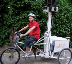
for their StreetView feature.
(Photo: Google)
It looks like Google Streetview will soon be coming to a bike path near you.
We first reported back in June on the buzz about Google’s new mapping tricycles — intended to capture streetview footage of roads where cars can’t go.
Since then, we’ve been wondering when the trikes will start showing up on Portland streets. Last week, we heard the first rumor, via Twitter, of a street view trike appearance on the Springwater Corridor near SE 112th.
Yesterday, reader Marc Schuette got in touch about another sighting, and included a video clip of the trike in action. Check it out after the jump.
Schuette wrote:
“I was biking out near Airport Way on [the I-205 bike path] a couple of hours ago and came across the Google Maps Bike. He was riding the ramps up and down from Airport Way to the 205 multi-use path. He’s part of a team from San Diego that trucks the bike(s) around and rides/maps. The setup weighs 300 lbs and he rode 20 miles yesterday.”
Here’s the quick video he took:
– Also check out our in-depth story last month about the emergence of online bike route planning systems, including rumors of Google involvement.

