

(Click to enlarge)
A graduate student at Portland State University’s Center for Urban Studies has made exciting progress on a tool that will allow the community to report close calls, collisions and problem locations.
The last time I mentioned a close calls map was in January of 2006. Several months after that story I received an email from Joe Broach, a Southeast Portland resident (from Missoula Montana) who’s working on his PhD in transportation at PSU. He wanted to know if anything had come of that project. When I said no, he decided to take on the task himself.

(Photo © J. Maus)
The idea was to build an online tool to capture information about collisions and near misses involving bicycles that are never reported (or are reported from a car-centric point of view).
Joe said he was first inspired to do this in the wake of the two bicycle fatalities in Portland last October. Traffic safety was front page news after those incidents and Joe said he knew the stats and graphics about crashes in the media were incomplete.
“It was frustrating, because I knew the data was limited. Cyclists know so much, they’re like pedaling databases, but that information wasn’t being captured.”
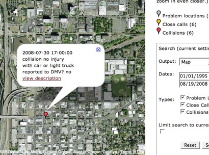
The new tool — tentatively named the Bike Safety Reporting and Analysis Tool — is integrated with Google Maps and can feasibly be used for any city or location. Users must register with a valid email address and once logged in, can fill out a simple form to record the specific details of their incident (date, time, type vehicle involved, etc…) and share a description of what happened. Users can also report “problem locations” by locating the area on the map and describing their concerns.
In addition to logging incidents and concerns, users of the tool can view existing reports (screenshot below). The incidents are color coded by type (near miss, problem location, or collision) and users can filter their view by geographic area, date incident occured, and type of incident. There is also an option to output the data via the standard Google Map view, by a text-only view, or via a comma separated value (CSV) file.
The potential of this tool is staggering. The data can be used any number of ways and it has been developed with standardized coding languages so it can be shared across many platforms.
Another exciting component is that, upon registration, users can opt-in to an email list giving permission to be contacted about safety research or analysis in and around locations they’ve reported on.
For example, let’s say PDOT wants to get feedback on a certain neighborhood traffic safety issue in a specific location. They could query the database and send an email to everyone who has reported a bicycle crash or near miss in that area and invite them to the meeting.
The tool is going through some final testing and will be hosted on BikePortland.org once it’s ready for prime time (it will take the place of the Close Calls reports which has over 600 comments posted in the last three years).
What do you think about this? I realize we’re not letting you really kick the tires yet, but if you have feedback or questions, Joe and I would love to hear them.
Stay tuned…