
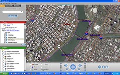
 I’ve just learned of an exciting development in Portland’s quest for an interactive bike route map. It looks as though Metro is trying to partner up with Google and their new Google Earth program. No official partnership yet, but Metro is actively experimenting with the technology (check the screenshot on the left).
The idea is to meld the popular Bike There! map with Google Earth so you can easily view and navigate the safest, most ideal bike route in a 3-D, satellite view of the city! Once this is finalized and fully functioning, you’ll be able to type in where you want to go and the program will select the most bike-friendly route automatically. Then, you can do 3-D flyover of the route before heading out.
As of last night, Metro has made it possible to play with this technology on their website. Here’s how to get started:
- Download the free Google Earth beta application onto your PC (Google says it is working on the Mac version)
- Then download this .kmz file of Metro’s Bike There! Map.
- Open Google Earth on your computer, and then from within GoogleEarth, go to file > open and open the Metro file.
- Use the dashboard in Google Earth to fly over the region and have a bird’s eye view of the bike routes.
Note: the trip planner is not yet available. Metro is still exploring the use of this technology. They would love to know what you think. Please leave your feedback in the comments.