As Jonathan reported earlier this afternoon, the city has just released its most thoroughly vetted list yet of which streets would see improvements from a proposed income tax for streets.
How solid is this list? Well, this is the first time the city has ever put it on a map.
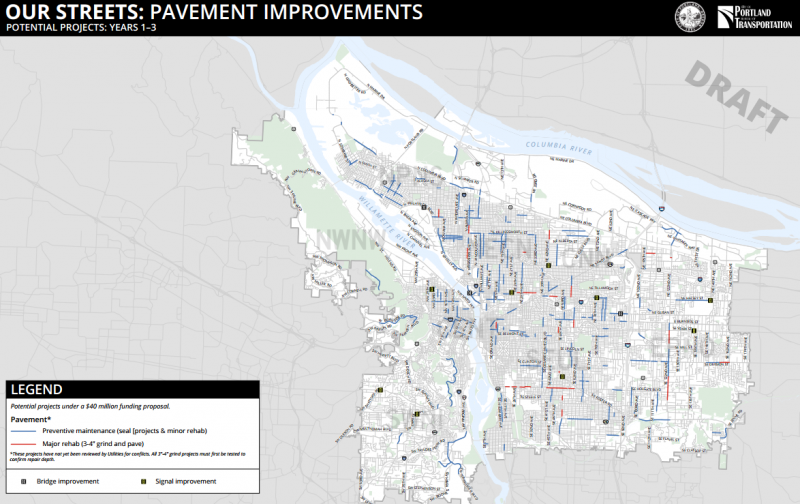
Or, to be specific: three maps. Here they are.
Paving projects

(Click the image to enlarge, or click here for a zoomable PDF)
A bit more than half of the money from the proposed tax (53 percent) would go to maintenance. And a large majority of that money (38 percent of total revenue) would go to repaving big streets.
As you can see from the map above, the vast majority of miles paved citywide in the first three years — the blue lines — would be “fog seal,” the quick cheap method embraced by the city in the last two years that reduces water seepage and other incremental damage to the pavement.
A smaller set of lane-miles, marked in red on the map, would get three to four inches of grinding and a full repaving job.
If you look at the PDF version of the map, you’ll see that, perhaps unsurprisingly, almost all the full repave projects would be on high-traffic streets such as SE 122nd Avenue, inner SE Holgate and NE Broadway in the 28th Avenue area. These are also, of course, the streets that are disintegrating the fastest because they get the most freight and bus traffic.
Meanwhile, some important bikeways (N Vancouver and Williams between Shaver and Killingsworth, for example, or SE Sandy Boulevard) would receive fog seal treatments in the first three years.
Advertisement

Safety projects

(Click the image to enlarge, or click here for a zoomable PDF)
One of the surprises on this map: a new neighborhood greenway on Northeast 9th Avenue north from the Lloyd District. Our Streets project manager Mark Lear said he understood that project was raised to become a high priority based on the high number of family-wage jobs it would help people connect to.
Another takeaway: though inner North and Northeast Broadway continues to be a focus of city plans for protected bike lanes, this plan envisions the project extending only to 24th Avenue in the first three years, rather than all the way to Cesar Chavez Bouelvard as envisioned by the Bicycle Transportation Alliance.
Safety projects and income

In general, the project list continues to show something that was obvious when we created our own map of the city’s working list: a huge share of the walking and biking improvements will land east of 82nd Avenue, neighborhoods that have Portland’s lowest median incomes.
Members of the East Portland Action Plan Bike Subcommittee, Lear said, “feel like this project is prioritizing East Portland safety improvements like nothing we’ve ever done before.”
Lear said that after the first three years, the city might have also done enough planning for protected bike lanes to be headed to East and Southwest Portland, too.
“What are those separated facilities that can really work on some of those bigger streets?” Lear said. “Hopefully in the 4 to 6 year time horizon we can get into more of that.”
Another major transportation improvement not shown on this map: a north-south frequent service bus line on 122nd Avenue, East Portland’s first.
Commissioner Steve Novick said Monday that this came out of a recent promise from TriMet General Manager Neil McFarlane.
“If we make $8 million of safety improvements along 122nd, they are confident that they can provide frequent service along that street,” Novick said.
Stay tuned for more coverage from Monday’s hearing on the proposed income tax, and see the city’s website for more details on how it’d spend the money.