
Mapnificent is a new online mapping tool that shows you where you can travel via public transit within a given time from any destination. It was developed in Germany by Stefan Wehrmeyer and seems like it’d be an excellent resource for anyone who is a frequent bus or light rail user.
Simply drop the pin at your origin, type in your destination, slide the time scale (the default is 15 minutes) and voila, you get an idea of where you can travel within that time-frame.
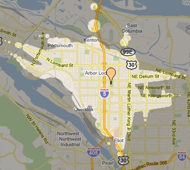
I dropped the pin near my home address in North Portland and here’s what the map returned for a 15 minute time-frame…
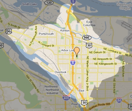
The tool doesn’t offer an option for bike-only trips, but there is a setting that asks, “Do you have a bike with you?” When I ticked that box, here’s how the map expanded…
I don’t use transit much because it costs too much and I have more range and flexibility on my bike (not to mention it’s a lot more fun!); but for those who do use transit, or for advocates looking to make the case for transit, this is a very nifty tool.
I’d love to see this with a “bike-only” option! In most cities, the range of a bike at average speeds (U.S., not Dutch) would surprise a lot of people.
For more on Mapnificent, check out this video and a blog post by Mr. Wehrmeyer.
For more on low-car living check out PortlandAfoot.
[H/T to Gabriel Amadeus and others on Twitter for sharing the link.]