“We should avoid putting all of our eggs in the freeway basket. In the long run, the most efficient mass transportation is by means other than private automobile… catering to the whims of the individual in his own automobile has proven to be an outrageously expensive luxury…”
— City Club of Portland, 1960
50 years ago this week, The City Club of Portland published a report that provides a window into the mood of our city toward transportation at the height of the automobile age.
The Report on Freeways Location was published by a five-member City Club committee on June 24th, 1960. The document was drafted in order to provide the State Highway Commission and city planners guidance to decide the best route for a future freeway that would pass through downtown.
1960 was just four years after the U.S. Congress passed the National Interstate and Defense Highways Act. Using gas tax revenue, the federal government offered to pay 90% of the tab for highway construction.
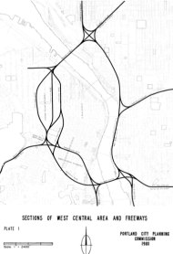
In their report, the City Club committee analyzes several possible locations of a new freeway route through downtown (see map graphic at right) that would connect freeways on the west side to the future Marquam Bridge and the already-built Banfield/I-84 on the east side. The two options under discussion were the “Clay-Market Route” and the “Foothills Route.”

(Source: City Club of Portland, 1960)
What struck me in reading this report is the obvious skepticism about freeways from the researchers and their clear understanding of how new freeway construction would impact surrounding land use. Even with the feds happily handing over 90% of the tab, the City Club was far from sold on the idea of rushing into freeway construction and they were candid with their feelings about car use in general.

(Photos © J. Maus)
“The automobile is creating a monstrous problem that Portlanders are only beginning to appreciate. It tends to transform people into impersonal machine operators who lose identity and who lose appreciation of the existence of a human in the other vehicle. This undesirable effect of the psychology of the individual is only slightly overshadowed by the problem created by the attempt of vast numbers of these machines to get to the same place at the same time.”
In the “Discussion” section of the report, the researchers note that to truly solve the “problem of getting people moved from one place to another” there should be plans for “comprehensive public transportation as well as for the private auto”:
“We should avoid putting all of our eggs in the freeway basket. In the long run, the most efficient mass transportation is by means other than private automobile… Cities have found that catering to the whims of the individual in his own automobile has proven to be an outrageously expensive luxury which the cities cannot possible continue to satisfy fully.”
The committee made it clear they felt the decision on the new freeway — set to be made just weeks after this report was published — was being rushed. They wanted to wait until a comprehensive traffic study could be completed before any decisions were made (one was in the works, but wouldn’t be done for 18 months). Begrudgingly, the committee recommended the Clay-Market Route because they felt it would integrate more easily with city traffic (bringing people closer to their destinations than the Foothills Route), transit, and parking needs. They were also concerned that the Foothills Route would cut off some parcels of land from the downtown core.

I-405 in the background.
In the end, the Foothills Route was selected. It was noted in the report that the Foothills Route would be less expensive to build, would not become congested as quickly, and would be easier to build.
Last week I went on the Dead Freeways Ride led by local urban historian Shawn Granton. We stood on a small patch of grass outside some apartments just south of Portland State University and I-405 (the Foothills Route section). Granton told us how the freeway had cut off this and several other residential areas from the rest of the city. It seems some of the City Club’s concerns were warranted.
Today, the Project Sponsors Council of the Columbia River Crossing project is meeting in downtown Portland. Hopefully they and other planners and decision makers will use the same caution in building highway projects as this five-member City Club committee did 50 years ago.
— You can download a PDF of the Report on Freeways Location here. For more on Portland’s freeway history, read The Dead Freeway Society published in the Portland Mercury back in September.