

View slideshow below
It’s hard to top a ride around Crater Lake, but today’s journey came pretty darn close.
We left Dorena Lake (Elev. 723) and headed east; 55 miles to Oakridge. On this misty morning, we meandered along a bike/ped only trail that led us into Brice Creek and the Umpqua National Forest.
Surrounded by a tunnel of green, we ascended gradually. The babble of the creek, as it tumbled over rocks and logs just yards from our pedals, was the only sound to be heard.
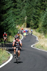
As we made our way upward, the mist gave way to bright sunshine and the real climbing began. With grades as high as 8.8%, we gained 4,000 of elevation in just under 40 miles. Easing the pain was a dreamy, newly paved road; I saw only one non-Cycle Oregon car the entire day.
We rode by wildflowers; rich, green, ferny meadows, and weathered rock. The exposed switchbacks reminded me of the climbs above Santa Barbara that I would float up back in my glory days. Today, when my legs winced, I tried resurrect those muscle memories; but I think my legs have amnesia.
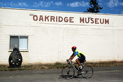
Once the final climb was conquered, we descended a serpentine road that dropped us back into the mist, and eventually into Oakridge.
Tonight we’re camping on the athletic fields of Oakridge High School. Tomorrow’s penultimate day takes us 65 miles (3,300 ft. elev. gain) into the town of Rainbow on the Mackenzie River.
View the full slideshow below:
Created with Admarket’s flickrSLiDR.
