Metro has reason to be proud of their Bike There! map. In a word, it’s awesome. It’s one of those maps that gets me inspired to explore new places every time I unfold it. Given the extensive coverage and user-friendly details, it’s no surprise they want to celebrate the launch of the latest version.
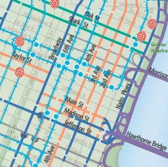
Around since 1982, this is the eighth edition of this popular map. Highlights include maps of 21 cities around the region, recreational routes, more detailed street ratings, labels for steepness, and full listings of existing rail lines to help you make that multi-modal trip (and/or steer clear of pesky tracks). Of course it’s also printed on super-durable, waterproof paper.
To get folks excited about the new map, Metro has three events planned.
The first one is a behind-the-scenes look at the making of the map that happens at Metro headquarters at noon today.
Next week (5/13) is the big bash. From 4 to 6 pm, Metro will host a party with the main attraction being a Goldsprint competition between “local media celebrities.” Yes, you read that right. This is your chance to watch your favorite local reporters spin their hearts out on a stationary trainer.
Signed up so far are Dave Salesky from KATU, Bruce Sussman from KOIN, Willamette Week’s Mark Zusman, Mark Nelsen from KPTV, Joseph Rose from The Oregonian, Peter Korn from the Portland Tribune, Justin Carinci from the Daily Journal of Commerce and others. (Unfortunately I’ll be out of town and will miss out on the fun.)
Weather reporters will go against print/web reporters and the overall champion will get to face Metro President David Bragdon in a final sprint showdown.
Rounding out their trio of Bike Month/Bike There events is a presentation titled, Why not bike there? on May 26th that will focus on the Community Cycling Center’s Understanding Barriers to Bicycling project.
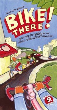
The Bike There! map costs $9. You can buy it at local shops or buy it online from Powell’s Books and help support BikePortland.org with each purchase.


Jonathan,
Is there any chance this map will be available online to download for free? I see that Metro provides the Walk There maps in .pdf for free download.
Thanks
Are you a local “local media celebrity”?
is there a free paper version? digging around on their site it looks like they were going to offer one in addition to the $9 road-worthy one… I’d love to have a paper version for home… feels like a waste to have a $9 map on my wall…
I found a 2007 version of a Google Earth BikeThere map at http://library.oregonmetro.gov/files/bikethere.kmz so I wonder if they’re going to offer an updated one…
there are also some less detailed system maps in there…
It’s great, except for all the errors and omissions. Don’t get me wrong – it’s cleaner, easier to read, covers a larger area, and is visually stunning. That said:
1. It’s missing the back way into Champoeg State Park, which is a road and MUP.
2. It seems to promote Springdale as a preferred route over the western hills, despite the fact that it’s a ridiculously steep unpaved rocky trail.
3. It has numerous classification errors in Clackamas County. (and other places)
4. It’s missing the back way into Milo McIver State Park.
Also, it doesn’t fold as nicely as in previous years – did they change the material?
I give it a 10 for style and a 7 for accuracy. If you’re going to plan routes for rides, use this map, but only in concert with other sources – don’t rely on this map alone.
I think $9 is a small price to pay for such a great map. When friends/family are in town its usually the one I give them to get around with whether they’re biking or not.
The other one that’s great is that pocket sized one from the Portland Office of Transportation.
If this is a Metro map- you should be able to download a printable version for free
“you should be able to download a printable version for free”
i was told they wouldn’t be offering this service, since they’re concerned about undercutting sales. imo, a mistake – i’d contend that it would help drive sales. Not to mention offer a useful governmental service to people who can’t justify paying $9 for a map.
bikieboy (#7) – I that’s true, then that’s a shame – an online map could be updated to correct errors. We’re stuck with all the errors on this map for another 3 years.
The worst part is Metro’s designation of what constitutes “Caution Area” – a lot of the orange roads are mis-marked. Thiessen Rd in Oak Grove, for example. The part with the blind hill and no shoulder is not marked “Caution Area”, and the part with the 8′ shoulder that is straight as an arrow *is* marked such. Hwy 26 is marked “Caution” even though it has 14’+ shoulders. Roads not marked caution that should be (due to fast drivers, blind curves, and steep, curvy hills) include Amisegger, Bull Run Rd, Lusted Rd, South Clackamas River Dr, and others. Gales Creek is listed as high traffic – it’s not, it’s very low traffic, but you don’t know that because the 45mph speed limit on that road consigns it to orange.
The map could also be improved by showing which parks have campgrounds (Stub Stewart, Milo McIver, Champoeg, Barton, Oxbow), using a dedicated symbol for college campuses (who’s most likely to be using this map?) and especially hospitals.
It’s a great looking map, and the expansion of the regional portion is very welcome and was badly needed.
Oh, and it’s a Metro map – shouldn’t it show the urban growth boundary?
Excellent job with the map, Metro, but it can be even better next time – you need more field checking by experienced cyclists, especially for the roads outside the urbanized area.