“It’s a celebration!” beamed a helpful person at the check-in desk as I walked into the big open house for the Central City in Motion plan last night at UO’s White Stag Building. “We have cookies and temporary tattoos!” It was indeed an upbeat vibe as PBOT presented projects to the public for the first time since the plan passed City Council in November.

Beyond the cookies and tattoos, I was glad to see PBOT not only shared info about current and upcoming projects, but also used the event to promote Biketown, TriMet Hop passes, and electric scooters (Bolt was giving away free helmets). If we want to move the needle, it’s not enough to just build infrastructure, we have to use every tool we have to pry peoples’ hands off their steering wheels.
Inside the room where the posterboards hang, there were important details and conversations shared about upcoming projects on NW Everett, Flanders and Burnside (I’ll get to those later), but Naito Parkway stole the show. Or should I say, Better Naito Forever stole the show.
Believe it or not, Better Naito Forever the official project name for PBOT’s plans to finally create protected space for bicycle users on Naito. The name alludes to the history of this project that began as a two-week trial organized by Better Block PDX in 2015. Temporary tattoos for a permanent project. Get it?
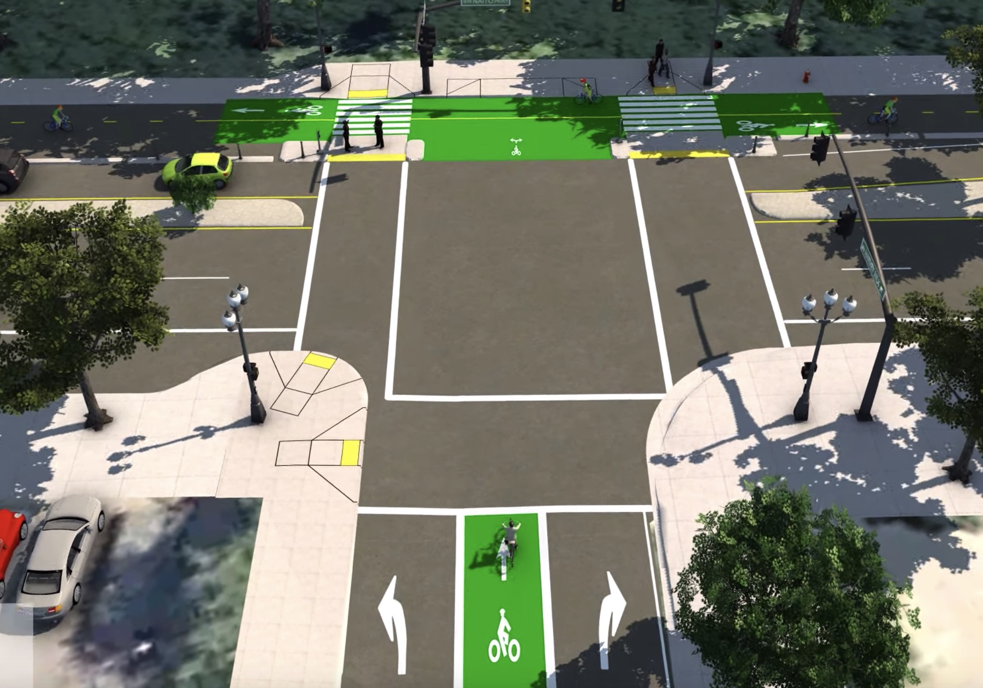
Cheekiness aside, the most exciting part of the open house (to me at least) was the 4 minute, 27 second visualization of Better Naito Forever. Created by project consultants David Evans and Associates, Inc., the video offers a realistic flyover of the City’s plans to reconfigure the eastern (northbound) side of Naito Parkway. According to the David Evans & Associates rep, the images show the 30% design stage, which means what we see is by no means final; but it’s also far beyond a conceptual rendering.
Here are some stills from the video:


Advertisement

Starting at SW Main, we first zoom northbound and see the bi-directional bikeway alongside the other lane. A six-inch concrete curb separates bicycle and car users. Unlike the current design, PBOT plans at this stage show no vertical delineation beyond this curb for most of the bikeway. Thankfully, metal bollards are shown at intersections.
At crossings of streets like Taylor and Yamhill we see large sections of green-colored pavement. There will also be small concrete islands for people to wait to cross Naito after they’ve crossed over the bike lanes. The islands also serve as foundations for bike-only signals and push-buttons to trigger “Walk” signs. These crossings will be a vast safety improvement not only because they’ll shorten the crossing distance and clarify movements, they’ll also encourage drivers to slow down as the road narrows.
We can also see the sidewalk planned for the western edge of Waterfront Park. A project consultant said a few trees will need to be removed in order to make room for the sidewalk. Construction on Better Naito Forever is scheduled to begin toward the end of 2020 and PBOT confirmed last night that the existing version of (temporary) Better Naito will stay in place until then.
Keep in mind that Better Naito Forever is running about 18 months or so behind a related project that aims to create a major new bikeway on the southern portion of Naito. I was told last night that the SW Naito Project is set to break ground this October. Once it’s complete, PBOT plans to create a temporary connection between SW Jefferson that goes under the Hawthorne Bridge viaduct and connects at Better Naito at the Salmon Street fountain.
Gwen Shaw, a Better Block PDX volunteer who served as project manager for Better Naito before PBOT took over the reins and is now an engineer at Toole Design, shared with me after the open house that, “Jefferson and Naito will be a game-changer and is something that would have been nearly impossible to tackle with interim solutions.” Shaw, who prefers the name “Perma-Naito”, said she likes what she sees from PBOT so far, but she’d like to see a bit more vertical separation and more done to make sure drivers don’t use the facility. “There’s still quite a bit going on [at intersections] that will need to be well designed to avoid confusion,” she said.
If all goes according to plan we’ll have a high-quality protected bikeway for 1.5 miles of Naito Parkway from SW Lincoln Street to the Steel Bridge (and beyond!) by summer 2021.
Stay tuned for more coverage of other projects shown at last night’s open house.
CORRECTIONS: The original version of this article said Bird was the scooter company at the open house. That was incorrect. It was Bolt Mobility. Also, I referenced David Evans & Associates Inc as “DKS”. That was a mistake. I regret the errors.
— Jonathan Maus: (503) 706-8804, @jonathan_maus on Twitter and jonathan@bikeportland.org
Never miss a story. Sign-up for the daily BP Headlines email.
BikePortland needs your support.


Genuine question: Why isn’t that neat tree-lined median in between the bike lanes and the automobile lanes? It would be significantly safer, and be a much more attractive ride. There can’t be a significant cost difference in placing the median 12 feet to one side or the other.
Nevermind, that just appears to be a virtual depiction of the existing median. I didn’t recognize it. I can see why it’d cost more to move the existing median, though it seems like they’re missing a huge opportunity to move it as part of this project.
Even better would be to use the existing median to separate bike and car traffic, put in some traffic separators or jersey barriers to fill the gaps, and save all of that green paint plus a pile of cash. They would have to redo the traffic signals for two-way car traffic on one side, or just replace them all with stop signs which would be safer and far more cost-effective. I guess it depends on whether we want to prioritize moving cars through downtown in the next decade or if it’s time to try something else.
Well, it looks to me like that tree lined median is not continuous and is only a space holder for when there isn’t a left turn lane. Once there is a turn lane the median goes away. I don’t see how we could have a continuous tree lined median and support the turn lanes. If you get rid of the median when there is a turn lane then the auto traffic is forced to zig zag which I don’t think is good.
“PBOT confirmed last night that the existing version of (temporary) Better Naito will stay in place until then.”
This is excellent news!
Including actual sidewalks for people to walk on will be a big improvement. It will feel more welcoming, and may help keep phone-gazing pedestrians from wandering into the bikelane and getting victim-blamed when the bike rider they stepped in front of hits them.
of particular note…the video is car-centric and from the car’s viewpoint. but, yeah, super cool this is becoming permanent!!
Flying car-centric!
Said flying car is shown in the top right of the top-right photo. 🙂
At first I was thinking Lawful Drone because it seemed to be waiting at traffic signals but then I saw that it had the power to put other actors in stasis. Cars frozen mid block, bike riders holding track stands with the cranks vertical. Maybe it’s a Christmas Ghost?
Well KATE, if you watched the second half of the video you’d see the perspective of a cyclist going SB on Naito.
Thanks
I’m very excited about this. The designs look really nice. The pedestrian crossing islands will make crossing Naito on foot substantially more pleasant.
My only nitpick is that with the new sidewalk being built behind the existing curb, there will be room for slightly more substantial separation between the 2-way bike lane and the adjacent northbound vehicle lane. Cycling southbound in the against northbound car traffic isn’t that pleasant in the current Better Naito configuration isn’t that pleasant, and there’s the opportunity to improve on that.
This could be accomplished by building planters in the ground, like this street in Montreal:
https://goo.gl/maps/YdDkW4u6kp18FBQc8
Or using prefabricated planters behind a concrete traffic separator, like this street in Vancouver:
https://goo.gl/maps/jyr93ajj49NL4qhP9
Or, in Seattle:
https://goo.gl/maps/4ScJ8xpMg2fJcBsK8
Or even with just concrete, like in London:
https://goo.gl/maps/wHoa3XEGsNUtRtFTA
I agree that beefier separation would be great. The planters at the curb do a lot make it *feel* like there is more protection (as well as making it clear to drivers that the bike paths are not a strange car lane), but I prefer a design like this with even more clarity: https://goo.gl/maps/iYnTYxNyNEMT42748
Yes this takes more room, but bikes, peds, and cars all have distinct paths to travel in.
I’d give it a B- if we’re to compare it against true “world-class” facilities. Having plastic bollards and no concrete separation everywhere but the intersections is a cost reduction, but really have we not learned from our past mistakes? Will there be bike signals to prevent collisions from those entering in from a cross street while Naito has a red?
One thing that’s confusing to me is why the southbound bike lane seemingly still remains in this design. Currently, anyone in the afternoon that’s traveling northbound (over the rails just past Steel Bridge) will know how many ditch the southbound lane (via left turn lane into 600 NW Naito’s lot) to cross over onto the cycle-track, even if they’re a block ahead of when the bidirectional lanes even begin.
Edit: disregard the plastic bollards and no concrete separation bit, I clearly didn’t read the actual post and rewatching the video makes it seem more “acceptable”
I have never enjoyed the “bi directional” yet undefined aspect of Naito bike “lane”, find it not to be safe nor fun, and stay out of it for that reason, as do many I know. How is the safety aspect of the bidirectional lane going to be handled? Will there be two actual bike lanes, or the guessing game?
I want to understand what your concern is. Do you also feel uncomfortable or unsafe riding in the bi-directional, undefined lanes of most multi-use paths like the waterfront path or the Springwater Corridor?
I’m less comfortable on paths with undefined lanes. Many people walk on the left side of a MUP because they want to see bike coming, which makes it confusing to give an alert when passing and hope they don’t move to the right.
It’s not as bad when it’s narrow because people are usually biking slower. But if you have a wide path then things can get uneasy with fast bikes.
The added sidewalk and the cement curb are a great start.
Add some railing to the sidewalk to keep pedestrians from wandering out there during festivals.
Add some heft to the curb to actually make it a protected bike path.
There’s a line down the middle, so 2 lanes. But it needs more directional bike lane markings in some places. Especially in the middle where drivers might think about crossing over into it.
Dabby “instigated the lease for public access to 3000 acres of land for bike riders” Dabby? No flies on him!
I too sorta mislike the Newish Naito two-way mess until it happens to be right in my way and then I grab it! Happily! Seems it’s gonna be kind of like Williams, a lot of protesteth too much and then suddenly it’s the most-used bike infrastructure in town.
Doesn’t seem to do anything for the omnishambles that is approaching Steel Bridge on Nairto from the North. No clear guidance of how to cross Naito – apparently you have to ride into the tracks, or ride across the traffic? But the other side is not bidirectional until after Steel. All that infrastructure just stops. It’s a mess.
Better Naito Forever will add a left turn box and receiving ramp at Naito / Davis, so people can transition to the two-way section there. It’s visible in the video from about 2 minutes in.
A separate project will add a pedestrian / bike crossing at Naito / Glisan, to create a path between the Flanders Greenway and the Steel Bridge. It’s funded, but still waiting for sign off from the railroad. A rendering of it was on display at the open house on Tuesday, but I don’t think it’s been posted online.
Awesome!
Still need a major fix for the cluster-f that is Naito where it meets the Steel Bridge. There needs to be a bike/ped crossing there.
This looks great. We might want more substantial bollards on those bulb-out pedestrian islands, though. Those are going to definitely get hit by vehicles.
I’d love to hand out stickers a TNR any idea where to get some?
When I read the headline I assumed they were only targeting the 4 blocks of Naito that are in NW. I was relieved that the title was incorrect. 🙂
There is something about a temporary tattoo saying “forever” that makes my brain glitch.
The added sidewalk and the cement curb are a great start.
Add some railing to the sidewalk to keep pedestrians from wandering out there during festivals.
Add some heft to the curb to actually make it a protected bike path.
This is fantastic. We need this upgrade to Portland’s waterfront — it’s better and safer for people walking, riding bikes, and driving cars.
How will the frequent need for vehicles on- and off-loading to Waterfront Park be dealt with? Currently vehicles park in the bike/ped Better Naito lanes to service Saturday Market, 5 de Mayo, the Rose Festival, the Blues Festival, etc. Maybe the bi-directional bike lanes should be on the west side of Naito to avoid this?
This is HUGE news, and thanks to everyone for keeping PBOT’s feet to the fire and finally make BN permanent.
Not only the bike lanes, but adding the sidewalk is a huge win. I don’t know why parks departments always get exempted from having to install sidewalks along major streets, when other adjacent property owners aren’t. I can think of a number of parks in the Portland area lacking sidewalks along adjacent roads, and we have the same problem where in Minneapolis.